close
-
Layers w
- Weather Layers
- Pro
- Pro
- Pro
- Pro
- Pro
- Pro
- More Layers
- Pro
- Pro
- Pro
- Pro
-
Upgrade to

3D
Trail Conditions
- Unknown
- Snow Groomed
- Snow Packed
- Snow Covered
- Snow Cover Partial
- Freeze/thaw Cycle
- Icy
- Prevalent Mud
- Wet
- Variable
- Ideal
- Dry
- Very Dry
Trail Flow (Ridden Direction)
Trailforks scans users ridelogs to determine the most popular direction each trail is ridden. A good flowing trail network will have most trails flowing in a single direction according to their intension.
The colour categories are based on what percentage of riders are riding a trail in its intended direction.
The colour categories are based on what percentage of riders are riding a trail in its intended direction.
- > 96%
- > 90%
- > 80%
- > 70%
- > 50%
- < 50%
- bi-directional trail
- no data
Trail Last Ridden
Trailforks scans ridelogs to determine the last time a trail was ridden.
- < 2 days
- < 1 week
- < 2 weeks
- < 1 month
- < 6 months
- > 6 months
Trail Ridden Direction
The intended direction a trail should be ridden.
- Downhill Only
- Downhill Primary
- Both Directions
- Uphill Primary
- Uphill Only
- One Direction
Contribute Details
Colors indicate trail is missing specified detail.
- Description
- Photos
- Description & Photos
- Videos
Trail Popularity ?
Trailforks scans ridelogs to determine which trails are ridden the most in the last 9 months.
Trails are compared with nearby trails in the same city region with a possible 25 colour shades.
Think of this as a heatmap, more rides = more kinetic energy = warmer colors.
- most popular
- popular
- less popular
- not popular
ATV/ORV/OHV Filter
Max Vehicle Width
inches
US Cell Coverage
Legend

Radar Time
Activity Recordings
Trailforks uses anonymized public activity data.
?
Activity Recordings
Trailforks uses anonymized public activity data.
?
Personal Heatmap
▶
Activity Types
all
/
none
▶
Options
2
Date range
month
–
Winter Trails
Warning
A routing network for winter maps does not exist. Selecting trails using the winter trails layer has been disabled.
Missing Trails
Most Popular
Least Popular
Trails are colored based on popularity. The more popular a trail is, the more red. Less popular trails trend towards green.
Jump Magnitude Heatmap
Heatmap of where riders jump on trails. Zoom in to see individual jumps, click circles to view jump details.
BC Backroad Status
![map legend]()
Service Road Atlas is a free to use, community-driven service for viewing and creating reports on the numerous back-country service roads around B.C. and Alberta.

Slope Aspect
Direction the slope faces
Trails Deemphasized
Trails are shown in grey.
Only show trails with no bike usage.
Suggested Layers
Based on selected activity type
Save the current map location and zoom level as your default home location whenever this page is loaded.
Save
No description for Ry has been added yet!
Login or register to submit one.
Activities Click to view
- Mountain Bike
40 trails
- E-Bike
37 trails
- Adaptive Bike
2 trails
- Winter Fat Bike
6 trails
- Hike
18 trails
- Trail Running
19 trails
Region Details
- 9
- 2
Region Status
Open as of May 23, 2026Stats
- Avg Trail Rating
- Trails (view details)
- 26
- Trails Mountain Bike
- 42
- Trails E-Bike
- 37
- Trails Adaptive Bike
- 2
- Trails Winter Fat Bike
- 6
- Trails Hike
- 18
- Trails Trail Running
- 19
- Total Distance
- 24 miles
- Total Descent
- 3,321 ft
- Total Vertical
- 447 ft
- Highest Trailhead
- 518 ft
- Reports
- 934
- Photos
- 8
- Ridden Counter
- 2,925
Sub Regions
-
Danmarks Tag
- 5
- 14
- 7
Popular Ry Mountain Biking Trails
• 95 ★ 5.0 • 761 ft • 0 ft • 171 •
Popular red difficulty singletrack. This multi-use trail can be used one direction. It features berm, drop and jump. On average it takes 1 minutes to complete this trail.
• 100 ★ 4.0 • 1,509 ft • 17 ft • 158 •
Popular red difficulty singletrack. This multi-use trail can be used one direction. It features berm, drop, jump and rock garden. Adaptive MTB rating: amtb black. On average it takes 3 minutes to complete this trail.
• 85 ★ 0.0 • 722 ft • 0 ft • 154 •
Popular black difficulty singletrack. This multi-use trail can be used one direction and has a moderate overall physical rating. It features berm, drop, jump and rock garden. On average it takes 1 minutes to complete this trail.
• 90 ★ 5.0 • 564 ft • 8 ft • 153 •
Popular red difficulty singletrack. This multi-use trail can be used one direction. It features berm, drop and jump. On average it takes minutes to complete this trail.
• 90 ★ 0.0 • 2,818 ft • 53 ft • 151 •
Popular blue difficulty singletrack. This multi-use trail and has a easy overall physical rating. It features berm and jump. Trail visibility is always easy to follow. On average it takes 4 minutes to complete this trail.
• 55 ★ 0.0 • 3,264 ft • 242 ft • 140 •
Moderately popular red difficulty doubletrack. This multi-use trail can be used one direction. It features berm. On average it takes 6 minutes to complete this trail.
• 55 ★ 0.0 • 3,219 ft • 147 ft • 139 •
Moderately popular red difficulty singletrack. This multi-use trail can be used one direction. It features berm, drop and jump. On average it takes 9 minutes to complete this trail.
• 100 ★ 0.0 • 784 ft • 37 ft • 138 •
Popular red difficulty singletrack. This multi-use trail can be used one direction. On average it takes 1 minutes to complete this trail.
Ry Mountain Bike Routes
1 mile • 191 ft • 2 • Out & Back •
The idea of Denmark's Tag has basically been to utilize the many elevation meters that are in the area to...
4 miles • 639 ft • 16 • Loop •
The idea of Denmark's Tag has basically been to utilize the many elevation meters that are in the area to...
5 miles • 824 ft • 18 • Loop •
The idea of Denmark's Tag has basically been to utilize the many elevation meters that are in the area to...
3 miles • 457 ft • 0 • Loop •
The MTB track in Siim Forest at Ry offers experiences for all MTB fans. Here are long descents, tough runs...
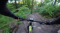
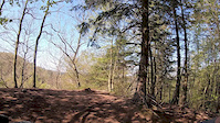
Photos of Ry Mountain Bike
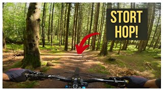
Videos of Ry Mountain Bike
trail: Bob & Leth
0:19 |
79 |
Jul 3, 2021
trail: Min Ven Simon
0:38 |
126 |
Apr 29, 2019

trail: Honey
0:27 |
33 |
Jan 30, 2019
trail: Honey
0:27 |
8 |
Jan 30, 2019
trail: Hello Kitty
0:24 |
172 |
Sep 12, 2023 , Ry

trail: Villa
0:05 |
128 |
Sep 12, 2023 , Ry

trail: Honey
0:06 |
109 |
Sep 12, 2023 , Ry
trail: Honey
0:06 |
105 |
Sep 8, 2023 , Ry
Recent Trail Reports
| status | trail | date | condition | info | user |
|---|---|---|---|---|---|
| Ålen | May 23, 2026 @ 11:22pm (Europe/Copenhagen) May 23, 2026 | Unknown | benjaminhoegh SSSL | ||
| Ålekvabben | May 23, 2026 @ 11:22pm (Europe/Copenhagen) May 23, 2026 | Unknown | benjaminhoegh SSSL | ||
| Villa | May 23, 2026 @ 11:22pm (Europe/Copenhagen) May 23, 2026 | Unknown | benjaminhoegh SSSL | ||
| Stairway to Knøsen | May 23, 2026 @ 11:22pm (Europe/Copenhagen) May 23, 2026 | Unknown | benjaminhoegh SSSL | ||
| Sort Guld | May 23, 2026 @ 11:22pm (Europe/Copenhagen) May 23, 2026 | Unknown | benjaminhoegh SSSL | ||
| Smeden | May 23, 2026 @ 11:22pm (Europe/Copenhagen) May 23, 2026 | Unknown | benjaminhoegh SSSL | ||
| Shortcut | May 23, 2026 @ 11:22pm (Europe/Copenhagen) May 23, 2026 | Unknown | benjaminhoegh SSSL | ||
| Rødt spor under knøsen | May 23, 2026 @ 11:22pm (Europe/Copenhagen) May 23, 2026 | Unknown | benjaminhoegh SSSL | ||
| Op til smeden | May 23, 2026 @ 11:22pm (Europe/Copenhagen) May 23, 2026 | Unknown | benjaminhoegh SSSL | ||
| Op til alt det sjove | May 23, 2026 @ 11:22pm (Europe/Copenhagen) May 23, 2026 | Unknown | benjaminhoegh SSSL |
Activity Feed
| username | action | type | title | date |
|---|---|---|---|---|
| DanielV | wishlist | trail | activity #96671299 and 14 more | Jun 10, 2026 @ 7:24am Jun 10, 2026 |
| DanielV | wishlist | route | activity #96525614 and 1 more | Jun 8, 2026 @ 12:55am Jun 8, 2026 |
| benjaminhoegh | update | trail | activity #95837675 | May 30, 2026 @ 4:22am May 30, 2026 |
| benjaminhoegh | update | region | activity #95824971 | May 29, 2026 @ 11:05pm May 29, 2026 |
| benjaminhoegh | update | route | activity #95824724 | May 29, 2026 @ 10:53pm May 29, 2026 |
Recent Comments
| username | type | title | comment | date |
|---|---|---|---|---|
| trail | Permanently closed! Blocked with trees | Jun 23, 2025 @ 8:21am Jun 23, 2025 |
Local Badges
-

Completionist2 awarded -

Epic Mountain Bike Climb 2k10 awarded -

Climbing 10k Badge14 awarded -

Mountain Biking 100k Badge0 awarded -

Epic Ride Descent 2k10 awarded -

Descent 10k Badge14 awarded
Activity Type Stats
| activitytype | trails | distance | descent | descent distance | total vertical | rating | global rank | state rank | photos | reports | routes | ridelogs |
|---|---|---|---|---|---|---|---|---|---|---|---|---|
| Mountain Bike | 40 | 24 miles | 3,320 ft | 11 miles | 446 ft | #2,353 | #7 | 6 | 934 | 3 | 2,497 | |
| E-Bike | 37 | 13 miles | 1,785 ft | 5 miles | 436 ft | #1,204 | #16 | 930 | 2 | 556 | ||
| Adaptive Bike | 2 | #176 | #11 | |||||||||
| Winter Fat Bike | 6 | #128 | #9 | |||||||||
| Hike | 18 | 15 miles | 1,706 ft | 7 miles | 446 ft | #2,436 | #16 | 929 | 116 | |||
| Trail Running | 19 | 15 miles | 1,739 ft | 7 miles | 446 ft | #1,971 | #16 | 929 | 21 |
Frequently Asked Questions About Ry
▼
What are the best places to ride in Ry?
Ry has 1 areas to explore for mountain biking. The top rated areas are:
▼
What are the highest rated mountain biking trails in Ry?
The highest rated mountain biking trails in Ry are:
- Ålekvabben (4.1/5)
- Villa (4.1/5)
- Smeden (4.1/5)
- Bob & Leth (4.1/5)
- Sort Guld (4.1/5)
▼
What is the best time of the year to ride in Ry?
Based on ride log data, the most popular months to ride in Ry are:
- April (14 activities)
- September (9 activities)
- February (8 activities)
▼
Where can I park to ride in Ry?
- By trail-niels
 & contributors
 - Admins: apply
- #28254 - 2,702 views
- ry activity log | embed map of Ry mountain bike trails | ry mountain biking points of interest
Downloading of trail gps tracks in kml & gpx formats is enabled for Ry.
You must login to download files.