close
-
Layers w
- Weather Layers
- Pro
- Pro
- Pro
- Pro
- Pro
- Pro
- More Layers
- Pro
- Pro
- Pro
- Pro
-
Upgrade to

3D
Trail Conditions
- Unknown
- Snow Groomed
- Snow Packed
- Snow Covered
- Snow Cover Partial
- Freeze/thaw Cycle
- Icy
- Prevalent Mud
- Wet
- Variable
- Ideal
- Dry
- Very Dry
Trail Flow (Ridden Direction)
Trailforks scans users ridelogs to determine the most popular direction each trail is ridden. A good flowing trail network will have most trails flowing in a single direction according to their intension.
The colour categories are based on what percentage of riders are riding a trail in its intended direction.
The colour categories are based on what percentage of riders are riding a trail in its intended direction.
- > 96%
- > 90%
- > 80%
- > 70%
- > 50%
- < 50%
- bi-directional trail
- no data
Trail Last Ridden
Trailforks scans ridelogs to determine the last time a trail was ridden.
- < 2 days
- < 1 week
- < 2 weeks
- < 1 month
- < 6 months
- > 6 months
Trail Ridden Direction
The intended direction a trail should be ridden.
- Downhill Only
- Downhill Primary
- Both Directions
- Uphill Primary
- Uphill Only
- One Direction
Contribute Details
Colors indicate trail is missing specified detail.
- Description
- Photos
- Description & Photos
- Videos
Trail Popularity ?
Trailforks scans ridelogs to determine which trails are ridden the most in the last 9 months.
Trails are compared with nearby trails in the same city region with a possible 25 colour shades.
Think of this as a heatmap, more rides = more kinetic energy = warmer colors.
- most popular
- popular
- less popular
- not popular
ATV/ORV/OHV Filter
Max Vehicle Width
inches
US Cell Coverage
Legend

Radar Time
Activity Recordings
Trailforks uses anonymized public activity data.
?
Activity Recordings
Trailforks uses anonymized public activity data.
?
Personal Heatmap
▶
Activity Types
all
/
none
▶
Options
2
Date range
month
–
Winter Trails
Warning
A routing network for winter maps does not exist. Selecting trails using the winter trails layer has been disabled.
Missing Trails
Most Popular
Least Popular
Trails are colored based on popularity. The more popular a trail is, the more red. Less popular trails trend towards green.
Jump Magnitude Heatmap
Heatmap of where riders jump on trails. Zoom in to see individual jumps, click circles to view jump details.
BC Backroad Status
![map legend]()
Service Road Atlas is a free to use, community-driven service for viewing and creating reports on the numerous back-country service roads around B.C. and Alberta.

Slope Aspect
Direction the slope faces
Trails Deemphasized
Trails are shown in grey.
Only show trails with no bike usage.
Suggested Layers
Based on selected activity type
Save the current map location and zoom level as your default home location whenever this page is loaded.
Save
No description for Sainte-Adèle has been added yet!
Login or register to submit one.
Activities Click to view
- Mountain Bike
148 trails
- E-Bike
80 trails
- Gravel Bike
0 trails
- Adaptive Bike
0 trails
- Winter Fat Bike
1 trails
- Hike
153 trails
- Trail Running
142 trails
- Snowshoe
58 trails
- Downhill Ski
14 trails
- Backcountry Ski
7 trails
- Nordic Ski
57 trails
Region Details
- 2
- 8
- 22
- 79
- 27
- 6
Region Status
Open as of Jun 3, 2026Stats
- Avg Trail Rating
- Trails (view details)
- 234
- Trails Mountain Bike
- 148
- Trails E-Bike
- 80
- Trails Winter Fat Bike
- 1
- Trails Hike
- 153
- Trails Trail Running
- 142
- Trails Snowshoe
- 58
- Trails Downhill Ski
- 14
- Trails Backcountry Ski
- 7
- Trails Nordic Ski
- 57
- Total Distance
- 197 miles
- Total Descent
- 47,427 ft
- Total Vertical
- 1,095 ft
- Highest Trailhead
- 1,642 ft
- Reports
- 1,228
- Photos
- 300
- Ridden Counter
- 43,159
Sub Regions
-
Parc du Mont Loup-Garou
- 6
- 8
- 9
- 1
-
Parc Freeride 40/80
- 1
- 1
- 1
-
Sentiers du Lac Quévillon
- 8
- 1
- 13
- 5
- 1
Popular Sainte-Adèle Mountain Biking Trails
• 100 ★ 3.7 • 7 miles • 1,217 ft • 915 •
Single Track route around entire park used for summer and fat bike riding in the winter. Lots of climbing with some steep sections along with some fast flowing downhill with berms, jumps, and wide bridges. Clockwise route recommended as...
Chemin du golf Permanently Closed
• 65 ★ 1.0 • 875 ft • 0 ft • 568 •
Moderately popular green difficulty closed singletrack. This mountain bike primary trail can be used both directions. On average it takes 1 minutes to complete this trail.
• 100 ★ 3.7 • 3,268 ft • 4 ft • 498 •
Popular blue difficulty machine groomed. This mountain bike primary trail can be used downhill primary. It features berm, drop, jump, roller coaster and wallride. Trail visibility is always easy to follow. On average it takes 10 minutes to complete this trail.
• 100 ★ 3.7 • 2,421 ft • 210 ft • 487 •
Popular green difficulty singletrack. This mountain bike primary trail can be used uphill only. On average it takes 7 minutes to complete this trail.
• 100 ★ 3.4 • 4,485 ft • 14 ft • 335 •
Sentier construit en honneur de Mel et Franck par la communauté de plein air de Sainte-Adèle. Le sentier commun, nommé MEL est bleu. Il y a 4 sections noires (EXPERT SEULEMENT) nommées FRANK au long du parcours.
• 95 ★ 3.3 • 3,104 ft • 88 ft • 333 •
Good flowing single track with some moderate up and down climbing. A few rock feature rollovers and some low berms in some corners. Fat bike in the winter.
• 95 ★ 4.1 • 1,811 ft • 3 ft • 325 •
Highly rated popular black diamond difficulty singletrack. This mountain bike primary trail can be used downhill primary with a 3 ft blue climb. It features berm, drop, jump and gap jump. Trail visibility is always easy to follow. On average it takes 3 minutes to complete this trail.
• 100 ★ 3.5 • 2,605 ft • 34 ft • 323 •
Popular blue difficulty singletrack. This mountain bike primary trail and has a moderate overall physical rating. It features berm, bridge and roller coaster. Trail visibility is always easy to follow. On average it takes 2 minutes to complete this trail.
Sainte-Adèle Mountain Bike Routes
★ 5.0 • 7 miles • 1,155 ft • 1 • Loop •
Le Parc du Mont , propriété de la Ville de Sainte-Adèle, est un véritable paradis de plein air...
★ 2.4 • 7 miles • 897 ft • 38 • Loop •
Route for going down ''encore, encore'', ''Abercombie Encore'' then down ''lakeshore'', ''érabiière''...
• 17 miles • 2,267 ft • 18 •
• 19 miles • 1,641 ft • 0 •
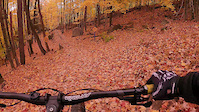
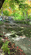
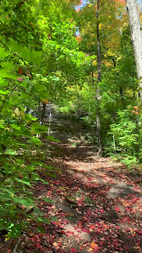
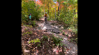
Photos of Sainte-Adèle Mountain Bike
Videos of Sainte-Adèle Mountain Bike
trail: Freeride 80
0:10 |
137 |
Oct 12, 2021

trail: Freeride 40
2:55 |
68 |
Jun 1, 2021
trail: Allongé
0:15 |
640 |
Sep 27, 2020
trail: Allongé
0:08 |
545 |
Sep 27, 2020
trail: Allongé
0:19 |
951 |
Sep 27, 2020
trail: Meilleur
11:47 |
306 |
Sep 23, 2019

trail: Freeride 40
3:33 |
649 |
Nov 14, 2016

trail: Érablière
4:12 |
694 |
May 22, 2016
Recent Trail Reports
| status | trail | date | condition | info | user |
|---|---|---|---|---|---|
| Franck-4 | Jun 3, 2026 @ 2:09pm (America/Toronto) Jun 3, 2026 | Ideal | dadonabike | ||
| Franck-1 | Jun 3, 2026 @ 2:09pm (America/Toronto) Jun 3, 2026 | Ideal | dadonabike | ||
| Mel & Frank | Jun 3, 2026 @ 2:09pm (America/Toronto) Jun 3, 2026 | Ideal | dadonabike | ||
| Chasseur | May 17, 2026 @ 12:38pm (America/Toronto) May 17, 2026 | Ideal | Jenrocket | ||
| Chasseur (ACCES HIVER) | May 17, 2026 @ 12:38pm (America/Toronto) May 17, 2026 | Ideal | Jenrocket | ||
| Champs de la Rolland - Crête Aux Vaches | May 17, 2026 @ 12:38pm (America/Toronto) May 17, 2026 | Ideal | Jenrocket | ||
| Pump Track Parc Lépine | May 17, 2026 @ 12:38pm (America/Toronto) May 17, 2026 | Ideal | Jenrocket | ||
| Le T-Bar | May 20, 2026 @ 1:34pm (America/Toronto) May 20, 2026 | Dry | Prospectsmap | ||
| Alexis | Feb 16, 2026 @ 9:32am (America/Toronto) Feb 16, 2026 | Ideal | 4505 | ||
| Grand-jaune | Feb 16, 2026 @ 9:32am (America/Toronto) Feb 16, 2026 | Ideal | 4505 |
Activity Feed
| username | action | type | title | date |
|---|---|---|---|---|
| MMaude | wishlist | route | activity #96234679 | Jun 4, 2026 @ 9:43am Jun 4, 2026 |
| MMaude | ridden | trail | activity #96234223 and 1 more | Jun 4, 2026 @ 9:36am Jun 4, 2026 |
| MMaude | wishlist | trail | activity #96234092 and 1 more | Jun 4, 2026 @ 9:34am Jun 4, 2026 |
| dadonabike | vote | trail | activity #96201721 | Jun 3, 2026 @ 7:42pm Jun 3, 2026 |
| dadonabike | add | report | activity #96175383 and 3 more | Jun 3, 2026 @ 12:50pm Jun 3, 2026 |
Recent Comments
| username | type | title | comment | date |
|---|---|---|---|---|
| trail | Wow ! Vraiment très beau. Je ne m'attendais... | Aug 10, 2025 @ 5:32pm Aug 10, 2025 | ||
| trail | Nice, simple trail | Oct 11, 2024 @ 3:06pm Oct 11, 2024 | ||
| trail | Not much to say about this one it’s just a... | Oct 11, 2024 @ 3:05pm Oct 11, 2024 | ||
| trail | I really enjoyed this trail | Oct 11, 2024 @ 3:04pm Oct 11, 2024 | ||
| trail | Wrote this trail for the first time and while... | Oct 11, 2024 @ 3:03pm Oct 11, 2024 |
Local Badges
-

Top 10 Trails1 awarded -

Descent 100k Badge3 awarded -

Big Ride 30k2,013 awarded -

Epic Ride 50k1,049 awarded -

Completionist5 awarded -
Completionist0 awarded
Bike & Skill Parks
| name | type | city | rating |
|---|---|---|---|
| Pump Track Mont-Rolland (Sainte-Adèle) | skill park | Sainte-Adèle |
Activity Type Stats
| activitytype | trails | distance | descent | descent distance | total vertical | rating | global rank | state rank | photos | reports | routes | ridelogs |
|---|---|---|---|---|---|---|---|---|---|---|---|---|
| Mountain Bike | 148 | 92 miles | 32,520 ft | 37 miles | 1,096 ft | #457 | #7 | 262 | 1,226 | 5 | 26,283 | |
| E-Bike | 80 | 42 miles | 6,729 ft | 17 miles | 1,096 ft | #2,533 | #19 | 3 | 1,158 | 3 | 1,003 | |
| Winter Fat Bike | 1 | #90 | #55 | 1 | 3 | 2 | 146 | |||||
| Hike | 153 | 84 miles | 29,925 ft | 32 miles | 1,096 ft | #1,113 | #6 | 32 | 1,189 | 9 | 1,293 | |
| Trail Running | 142 | 78 miles | 29,344 ft | 29 miles | 1,096 ft | #1,683 | #7 | 1,189 | 4 | 1,992 | ||
| Snowshoe | 58 | 34 miles | 4,859 ft | 14 miles | 1,053 ft | #142 | #4 | 9 | 8 | 249 | ||
| Downhill Ski | 14 | 4 miles | 3,812 ft | 4 miles | 545 ft | #421 | #8 | 1 | 454 | |||
| Backcountry Ski | 7 | 13 miles | 1,591 ft | 5 miles | 512 ft | #316 | #9 | 1 | 2 | 424 | ||
| Nordic Ski | 57 | 95 miles | 10,151 ft | 34 miles | 1,053 ft | #105 | #3 | 4 | 1,429 |
Frequently Asked Questions About Sainte-Adèle
▼
What are the best places to ride in Sainte-Adèle?
Sainte-Adèle has 9 areas to explore for mountain biking. The top rated areas are:
▼
What are the highest rated mountain biking trails in Sainte-Adèle?
The highest rated mountain biking trails in Sainte-Adèle are:
- Parallèle (4.2/5)
- Le Couloir du Français (4.2/5)
- La Couleuvre (4.2/5)
- Cap Bruce-Foy (4.1/5)
- Petit-Garou (4.1/5)
▼
What is the best time of the year to ride in Sainte-Adèle?
Based on ride log data, the most popular months to ride in Sainte-Adèle are:
- July (700 activities)
- August (514 activities)
- September (503 activities)
▼
Where can I park to ride in Sainte-Adèle?
There are 6 parking locations listed in Sainte-Adèle. The most popular parking spots are:
- Stationnement P1 - Parc du Mont Loup-Garou
- Stationnement P3 Ski de fond et vélo de montagne
- Parking Freeride 40/80
- Parking
- Stationnement
Activities
Trails
- By StephaneMarceau
 TRAILFORKS & contributors
 - Admins: VQ, bigjay, StephaneMarceau, Canadmos, HéPAN, PASA
- #7109 - 14,512 views
- sainte-adèle activity log | embed map of Sainte-Adèle mountain bike trails | sainte-adèle mountain biking points of interest polygons
Downloading of trail gps tracks in kml & gpx formats is enabled for Sainte-Adèle.
You must login to download files.