close
-
Layers w
- Weather Layers
- Pro
- Pro
- Pro
- Pro
- Pro
- Pro
- More Layers
- Pro
- Pro
- Pro
- Pro
-
Upgrade to

3D
Trail Conditions
- Unknown
- Snow Groomed
- Snow Packed
- Snow Covered
- Snow Cover Partial
- Freeze/thaw Cycle
- Icy
- Prevalent Mud
- Wet
- Variable
- Ideal
- Dry
- Very Dry
Trail Flow (Ridden Direction)
Trailforks scans users ridelogs to determine the most popular direction each trail is ridden. A good flowing trail network will have most trails flowing in a single direction according to their intension.
The colour categories are based on what percentage of riders are riding a trail in its intended direction.
The colour categories are based on what percentage of riders are riding a trail in its intended direction.
- > 96%
- > 90%
- > 80%
- > 70%
- > 50%
- < 50%
- bi-directional trail
- no data
Trail Last Ridden
Trailforks scans ridelogs to determine the last time a trail was ridden.
- < 2 days
- < 1 week
- < 2 weeks
- < 1 month
- < 6 months
- > 6 months
Trail Ridden Direction
The intended direction a trail should be ridden.
- Downhill Only
- Downhill Primary
- Both Directions
- Uphill Primary
- Uphill Only
- One Direction
Contribute Details
Colors indicate trail is missing specified detail.
- Description
- Photos
- Description & Photos
- Videos
Trail Popularity ?
Trailforks scans ridelogs to determine which trails are ridden the most in the last 9 months.
Trails are compared with nearby trails in the same city region with a possible 25 colour shades.
Think of this as a heatmap, more rides = more kinetic energy = warmer colors.
- most popular
- popular
- less popular
- not popular
ATV/ORV/OHV Filter
Max Vehicle Width
inches
US Cell Coverage
Legend

Radar Time
Activity Recordings
Trailforks uses anonymized public activity data.
?
Activity Recordings
Trailforks uses anonymized public activity data.
?
Personal Heatmap
▶
Activity Types
all
/
none
▶
Options
2
Date range
month
–
Winter Trails
Warning
A routing network for winter maps does not exist. Selecting trails using the winter trails layer has been disabled.
Missing Trails
Most Popular
Least Popular
Trails are colored based on popularity. The more popular a trail is, the more red. Less popular trails trend towards green.
Jump Magnitude Heatmap
Heatmap of where riders jump on trails. Zoom in to see individual jumps, click circles to view jump details.
BC Backroad Status
![map legend]()
Service Road Atlas is a free to use, community-driven service for viewing and creating reports on the numerous back-country service roads around B.C. and Alberta.

Slope Aspect
Direction the slope faces
Trails Deemphasized
Trails are shown in grey.
Only show trails with no bike usage.
Suggested Layers
Based on selected activity type
Save the current map location and zoom level as your default home location whenever this page is loaded.
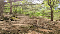
SaveExplore some of the best mountain biking throughout Florida, the southeastern U.S. and even internationally.
Santos includes 90+ miles of single-track diverse bike trails for beginners as well as expert-level trails that will challenge even the most elite riders.
Developed and maintained through a partnership with the volunteer-based Ocala Mountain Bike Association, Santos is perennially rated as one of the best mountain bike facilities in existence. Numerous wooden “features” and the Vortex Free ride area located in a former lime rock quarry provide extreme terrain in the flat lands of Florida.
source: FL State Parks
Primary Trail Type: Cross-Country
eBikes Allowed:
Yes
Land Status: State Park
Land Manager: Marjorie Harris Carr Cross Florida Greenway State Park
 google parking directions
Links
Region Supporters & Maintainers
![IMBA Bronze Ride Center]()
IMBA Bronze Ride CenterSponsor![]()
Ocala Mountain Bike AssociationMaintainer
IMBA Ride Center

Santos
Activities Click to view
- Mountain Bike
30 trails
- E-Bike
24 trails
- Hike
22 trails
- Trail Running
22 trails
Region Details
- 1
- 10
- 9
- 7
Region Status
Open as of Jul 7, 2026Stats
- Avg Trail Rating
- Trails (view details)
- 28
- Trails Mountain Bike
- 30
- Trails E-Bike
- 24
- Trails Gravel Bike
- 2
- Trails Hike
- 22
- Trails Trail Running
- 22
- Trails Dirtbike/Moto
- 1
- Total Distance
- 18 miles
- Total Descent Distance
- 3 miles
- Total Descent
- 556 ft
- Total Vertical
- 66 ft
- Highest Trailhead
- 105 ft
- Reports
- 1,699
- Photos
- 1,023
- Ridden Counter
- 44,686
Popular Santos Mountain Biking Trails
• 100 ★ 3.0 • 945 ft • 7 ft • 3,462 •
Popular green difficulty singletrack. This multi-use trail can be used both directions and has a easy overall physical rating with a 7 ft green climb. On average it takes 1 minutes to complete this trail.
• 95 ★ 3.6 • 1 mile • 8 ft • 2,796 •
is a blue trail (moderate) in the San Trail System. This trail is accessible from the San Trailhead if you follow in either direction. Depending on which leg of you take, it will put you on opposite ends of . is one of the easier blues...
• 90 ★ 3.9 • 2,031 ft • 2 ft • 2,505 •
Popular blue difficulty singletrack. This multi-use trail can be used both directions and has a moderate overall physical rating with a 2 ft blue climb. On average it takes 2 minutes to complete this trail.
• 90 ★ 4.1 • 1 mile • 34 ft • 2,440 •
Highly rated popular blue difficulty singletrack. This multi-use trail can be used both directions and has a moderate overall physical rating with a 34 ft blue climb. Trail visibility is always easy to follow. On average it takes 9 minutes to complete this trail.
• 95 ★ 4.4 • 2,090 ft • 12 ft • 2,347 •
Short but super fun trail. It has a decent berm section and a mini-hammock as well as a few places to get a little air time.
• 75 ★ 2.5 • 2,175 ft • 6 ft • 2,030 •
Old limerock road, very low difficulty. It is a Blue "moderate" trail only because it connects to Red "advanced" trails. Most of the trails on the side generally flow North/South, so Blue Highway is a great, fast access trail.
Santos Mountain Bike Routes
★ 5.0 • 60 miles • 1,126 ft • 59 •
First try at creating an out and back route Santos
★ 3.0 • 16 miles • 531 ft • 54 • Loop •
Hits most trails in Santos. Pretty difficult, we ate lunch right before we rode around the Vortex area....
73 miles • 1,854 ft • 38 • Point to Point •
Full run through Santos, Vortex, and Spider Kingdom. Features the most fun trails you can ride in Florida...
32 miles • 783 ft • 32 • Loop •
Loop from Santos trailhead to Land-bridge and back. Hits most trails for a little mix of all riding styles...
47 miles • 1,153 ft • 0 •
This is the 2025 route but 2026 will be 95% the same but include Wee Doggy. Follow the 250 signs day of...
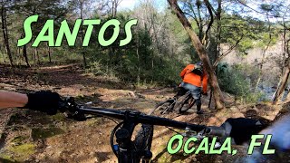
Photos of Santos Mountain Bike
Videos of Santos Mountain Bike

trail: John Brown
0:13 |
|
Apr 8, 2024
trail: John Brown
0:13 |
|
Mar 8, 2024
trail: John Brown
0:11 |
295 |
Feb 21, 2022

trail: Dr. Ruth
0:27 |
231 |
Jan 11, 2021
5:15 |
169 |
Mar 6, 2024

trail: Magic Mountain
0:41 |
553 |
Sep 5, 2009

trail: John Brown
6:21 |
700 |
Jun 19, 2009
Recent Trail Reports
| status | trail | date | condition | info | user |
|---|---|---|---|---|---|
| Blue Hiway | Jul 7, 2026 @ 8:52am (America/Nassau) Jul 7, 2026 | Ideal | Orangecycle1 | ||
| Pine Tree | Jul 7, 2026 @ 8:52am (America/Nassau) Jul 7, 2026 | Ideal | Orangecycle1 | ||
| Bunny | Jul 7, 2026 @ 8:52am (America/Nassau) Jul 7, 2026 | Dry | Orangecycle1 | ||
| Bryar Patch | Jul 7, 2026 @ 8:52am (America/Nassau) Jul 7, 2026 | Dry | Orangecycle1 | ||
| TOS | Jul 7, 2026 @ 8:52am (America/Nassau) Jul 7, 2026 | Ideal | Orangecycle1 | ||
| Marsh Mallow | Jul 2, 2026 @ 7:33am (America/Nassau) Jul 2, 2026 | Dry | Orangecycle1 | ||
| Cow Bone | Jun 18, 2026 @ 1:22pm (America/Nassau) Jun 18, 2026 | Ideal | CrazyBabsMTBer | ||
| Trailhead Parking | Jun 16, 2026 @ 8:31am (America/New_York) Jun 16, 2026 | Ideal | Orangecycle1 | ||
| Speedway | Jun 13, 2026 @ 12:24pm (America/Nassau) Jun 13, 2026 | Ideal | icthus13 SanFelasco | ||
| Bike Shop | May 27, 2026 @ 6:36pm (America/Nassau) May 27, 2026 | Ideal | icthus13 SanFelasco |
Activity Feed
| username | action | type | title | date |
|---|---|---|---|---|
| Orangecycle1 | add | report | activity #98654990 and 4 more | Jul 7, 2026 @ 11:10am Jul 7, 2026 |
| Orangecycle1 | add | report | activity #98273601 and 3 more | Jul 2, 2026 @ 9:16am Jul 2, 2026 |
| davo934 | vote | trail | activity #97736643 and 1 more | Jun 24, 2026 @ 5:41pm Jun 24, 2026 |
| banne007 | wishlist | trail | activity #97598381 | Jun 22, 2026 @ 6:53pm Jun 22, 2026 |
| missy321 | wishlist | trail | activity #97572359 | Jun 22, 2026 @ 10:50am Jun 22, 2026 |
Recent Comments
| username | type | title | comment | date |
|---|---|---|---|---|
| trail | Some areas of slippery pine needles may be... | Apr 27, 2025 @ 3:20pm Apr 27, 2025 | ||
| report | Pending to go | Apr 9, 2025 @ 11:17am Apr 9, 2025 | ||
| trail | It is actually one direction, North to South. | Jan 10, 2025 @ 2:39pm Jan 10, 2025 | ||
| trail | Severely overgrown but short and fun, even... | Jul 23, 2024 @ 2:01pm Jul 23, 2024 | ||
| trail | Nice long skinny wood feature halfway through... | Apr 30, 2024 @ 7:19am Apr 30, 2024 |
Nearby Areas
| name | distance | ||||
|---|---|---|---|---|---|
| Vortex | 5 | 1 | 3 | 1 | 0.8 km |
| Spider Kingdom | 8 | 2 | 1 | 2.4 km | |
| Landbridge | 4 | 4.9 km | |||
| Christmas Section | 1 | 2 | 6.5 km | ||
| Nayl's | 1 | 2 | 8.7 km |
Local Badges
-

Completionist24 awarded
Bike & Skill Parks
| name | type | city | rating |
|---|---|---|---|
| Santos Skill Park | skill park | Ocala | |
| Vortex | skill park | Ocala | |
| Hardrock Cycle Park | skill park | Ocala | |
| Motocross of Marion County | skill park | Ocala |
Activity Type Stats
| activitytype | trails | distance | descent | descent distance | total vertical | rating | global rank | state rank | photos | reports | routes | ridelogs |
|---|---|---|---|---|---|---|---|---|---|---|---|---|
| Mountain Bike | 30 | 14 miles | 528 ft | 3 miles | 59 ft | #285 | #104 | 1,022 | 1,699 | 5 | 17,263 | |
| E-Bike | 24 | 13 miles | 512 ft | 3 miles | 59 ft | #2,378 | #795 | 1,683 | 2 | 851 | ||
| Gravel Bike | 2 | #208 | #86 | 2 | 61 | |||||||
| Hike | 22 | 13 miles | 259 ft | 2 miles | 66 ft | #5,680 | #2,043 | 1,664 | 136 | |||
| Trail Running | 22 | 13 miles | 259 ft | 2 miles | 66 ft | #4,845 | #1,426 | 1 | 1,664 | 162 | ||
| Dirtbike/Moto | 1 | 3,743 ft | 3 ft | 433 ft | 10 ft | 184 | 8 |
Frequently Asked Questions About Santos
▼
What are the highest rated mountain biking trails in Santos?
The highest rated mountain biking trails in Santos are:
- Bryar Patch (4.3/5)
- Sinkhole (4.2/5)
- Shorty (4.2/5)
- Inchworm (4.1/5)
- WhimCycle Trail (4.1/5)
▼
What is the best time of the year to ride in Santos?
Based on ride log data, the most popular months to ride in Santos are:
- March (333 activities)
- May (262 activities)
- February (258 activities)
▼
Where can I park to ride in Santos?
There are 3 parking locations listed in Santos. The most popular parking spots are: View all parking and trailhead locations on the map to plan your visit.
▼
What is the longest trail in Santos?
The longest trail in Santos is Pine Tree at 3.1 miles. View all trails sorted by distance.
Activities
- By brenthillier
 NSMBA TRAILFORKS & contributors
 - Admins: OMBA, OMBA
- #4643 - 68,681 views
- santos activity log | embed map of Santos mountain bike trails | santos mountain biking points of interest
Downloading of trail gps tracks in kml & gpx formats is enabled for Santos.
You must login to download files.