close
-
Layers w
- Weather Layers
- Pro
- Pro
- Pro
- Pro
- Pro
- Pro
- More Layers
- Pro
- Pro
- Pro
- Pro
-
Upgrade to

3D
Trail Conditions
- Unknown
- Snow Groomed
- Snow Packed
- Snow Covered
- Snow Cover Partial
- Freeze/thaw Cycle
- Icy
- Prevalent Mud
- Wet
- Variable
- Ideal
- Dry
- Very Dry
Trail Flow (Ridden Direction)
Trailforks scans users ridelogs to determine the most popular direction each trail is ridden. A good flowing trail network will have most trails flowing in a single direction according to their intension.
The colour categories are based on what percentage of riders are riding a trail in its intended direction.
The colour categories are based on what percentage of riders are riding a trail in its intended direction.
- > 96%
- > 90%
- > 80%
- > 70%
- > 50%
- < 50%
- bi-directional trail
- no data
Trail Last Ridden
Trailforks scans ridelogs to determine the last time a trail was ridden.
- < 2 days
- < 1 week
- < 2 weeks
- < 1 month
- < 6 months
- > 6 months
Trail Ridden Direction
The intended direction a trail should be ridden.
- Downhill Only
- Downhill Primary
- Both Directions
- Uphill Primary
- Uphill Only
- One Direction
Contribute Details
Colors indicate trail is missing specified detail.
- Description
- Photos
- Description & Photos
- Videos
Trail Popularity ?
Trailforks scans ridelogs to determine which trails are ridden the most in the last 9 months.
Trails are compared with nearby trails in the same city region with a possible 25 colour shades.
Think of this as a heatmap, more rides = more kinetic energy = warmer colors.
- most popular
- popular
- less popular
- not popular
ATV/ORV/OHV Filter
Max Vehicle Width
inches
US Cell Coverage
Legend

Radar Time
Activity Recordings
Trailforks uses anonymized public activity data.
?
Activity Recordings
Trailforks uses anonymized public activity data.
?
Personal Heatmap
▶
Activity Types
all
/
none
▶
Options
2
Date range
month
–
Winter Trails
Warning
A routing network for winter maps does not exist. Selecting trails using the winter trails layer has been disabled.
Missing Trails
Most Popular
Least Popular
Trails are colored based on popularity. The more popular a trail is, the more red. Less popular trails trend towards green.
Jump Magnitude Heatmap
Heatmap of where riders jump on trails. Zoom in to see individual jumps, click circles to view jump details.
BC Backroad Status
![map legend]()
Service Road Atlas is a free to use, community-driven service for viewing and creating reports on the numerous back-country service roads around B.C. and Alberta.

Slope Aspect
Direction the slope faces
Trails Deemphasized
Trails are shown in grey.
Only show trails with no bike usage.
Suggested Layers
Based on selected activity type
Save the current map location and zoom level as your default home location whenever this page is loaded.
SaveShkodër or Shkodra historically known as Scutari or Scodra, is a city in the Republic of Albania. It is the capital of the surrounding county of Shkodër, one of 12 constituent counties of the republic. The city is one of the most ancient cities in the Balkans and the fourth most populous city in the country and exerts strong influences in culture, religion, arts and entertainment of northern Albania.Geographically, the city of Shkodër sprawls across the Mbishkodra plain between the freshwater marshlands of Lake Shkodër and the foothills of the Albanian Alps.[1] Like most of the Dinaric Alps, the mountains are dominated by limestone and dolomite rocks. The lake, named after the city of Shkodër, is the largest lake in Southern Europe close to the Adriatic Sea. The city is trapped on three sides by the rivers Kir in the east, Drin in the south and Buna in the west.
The region that today corresponds to the city territory was founded in the 4th century BC by the ancient Illyrian tribes of the Ardiaei and Labeates.[2] It is evidenced by the artefacts and inscriptions that were discovered in the Rozafa Castle. During that time the city was known under the name Scodra. The city has historically developed on a 130 metres (430 ft) hill, strategically located in the outflow of Lake Shkodër into the Buna. The Romans annexed the city after the third Illyrian War in 168 BC, when Gentius was defeated by the Roman force of Anicius Gallus.[2][3] In the 3rd century AD, Shkodër became the capital of Praevalitana due to the administrative reform of the Roman emperor Diocletian. With the spread of Christianity in the 4th century, the Archdiocese of Scodra was founded and was assumed in 535 by Byzantine Justinian I.
During many different epochs it has retained its status as a major city in the wider region, due to its strategic position close to the Adriatic Sea and the Italian port cities, but also with land-routes to other important cities and towns in neighbouring regions.
Activities Click to view
- Mountain Bike
48 trails
- E-Bike
40 trails
- Adaptive Bike
0 trails
- Winter Fat Bike
0 trails
- Horse
53 trails
- Hike
88 trails
- Trail Running
84 trails
- Dirtbike/Moto
20 trails
- Observed Trials
5 trails
- ATV/ORV/OHV
20 trails
- Snowmobile
4 trails
- Snowshoe
11 trails
Region Details
- 18
- 5
- 9
- 14
Region Status
Caution as of Oct 4, 2025Stats
- Avg Trail Rating
- Trails (view details)
- 86
- Trails Mountain Bike
- 48
- Trails E-Bike
- 40
- Trails Horse
- 53
- Trails Hike
- 91
- Trails Trail Running
- 84
- Trails Dirtbike/Moto
- 20
- Trails Observed Trials
- 5
- Trails ATV/ORV/OHV
- 20
- Trails Snowmobile
- 4
- Trails Snowshoe
- 11
- Total Distance
- 155 miles
- Total Descent Distance
- 59 miles
- Total Descent
- 34,277 ft
- Total Vertical
- 7,294 ft
- Highest Trailhead
- 7,316 ft
- Reports
- 16
- Photos
- 673
- Ridden Counter
- 765
Sub Regions
-
Buna River-Velipoja Protected Landscape
-
Liqeni i Shkodrës
- 1
-
Malësi e Madhe District
- 3
- 6
- 9
-
Thethi National Park
- 2
Popular Shkodër Mountain Biking Trails
• 5 ★ 0.0 • 4,252 ft • 10 ft • 6 •
Less popular blue difficulty singletrack. This mountain bike primary trail can be used downhill only and has a moderate overall physical rating. It features berm and other. Trail visibility is always easy to follow. On average it takes 6 minutes to complete this trail.
• 85 ★ 0.0 • 4,429 ft • 52 ft • 6 •
Popular green difficulty dirt/gravel road. This multi-use trail can be used both directions and has a moderate overall physical rating with a 52 ft green climb. It features berm. Trail visibility is always easy to follow. On average it takes 4 minutes to complete this trail. A license is required to use this trail.
• 100 ★ 0.0 • 4,140 ft • 238 ft • 6 •
Popular blue difficulty alpine singletrack. This mountain bike primary trail can be used both directions and has a moderate overall physical rating with a 238 ft blue climb. It features berm. Trail visibility is always easy to follow. On average it takes 11 minutes to complete this trail.
• 5 ★ 0.0 • 958 ft • 44 ft • 3 •
Less popular blue difficulty singletrack. This mountain bike primary trail can be used both directions and has a moderate overall physical rating with a 44 ft blue climb. It features berm. Trail visibility is always easy to follow. On average it takes 1 minutes to complete this trail.
• 5 ★ 4.0 • 4,695 ft • 745 ft • 3 • • hike
Less popular blue difficulty singletrack. This hike primary trail can be used downhill primary and has a moderate overall physical rating with a 745 ft blue climb. It features berm, rock face and rock garden. Trail visibility is always easy to follow.
• 5 ★ 0.0 • 4,580 ft • 0 ft • 3 •
Less popular blue difficulty singletrack. This mountain bike primary trail can be used downhill primary and has a moderate overall physical rating. It features berm. Trail visibility is sometimes hard to follow. On average it takes 6 minutes to complete this trail.
• 5 ★ 4.0 • 1 mile • 1,165 ft • 3 • • hike
Less popular blue difficulty singletrack. This hike primary trail can be used downhill primary and has a moderate overall physical rating. It features berm. Trail visibility is always easy to follow.
• 5 ★ 3.0 • 1 mile • 914 ft • 2 •
Less popular green difficulty alpine mixed. This multi-use trail can be used both directions and has a moderate overall physical rating with a 914 ft blue climb. It features berm and rock garden. Winter use: Classic snow grooming. Trail visibility is always easy to follow. On average it takes 57 minutes to complete this trail.
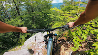
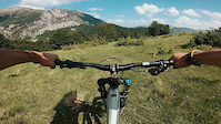
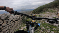
Photos of Shkodër Mountain Bike
Videos of Shkodër Mountain Bike

trail: Pylli i Dobkut Trail
0:40 |
67 |
Oct 25, 2022
trail: Qafa e Zorgjit
0:31 |
|
Jul 19, 2021

trail: Kui Vermoshit
0:34 |
|
Jul 12, 2021
trail: Kui Vermoshit
0:34 |
|
Jul 12, 2021
trail: Shirokë-Mali i Taraboshit
0:39 |
40 |
May 17, 2021

trail: Maja e Berizhdolit
0:40 |
28 |
Dec 21, 2020

trail: Access to Maja e Berizhdolit
0:55 |
19 |
Dec 14, 2020

trail: Maja Veleçikut vogël
0:41 |
16 |
Oct 23, 2020
Recent Trail Reports
| status | trail | date | condition | info | user |
|---|---|---|---|---|---|
| Access Road to Shpella e Rrathëve Trail | May 2, 2025 @ 5:45pm May 2, 2025 | Dry | radohrabcak | ||
| Access Road to Ujëvara e Grunasit | May 2, 2025 @ 9:29am May 2, 2025 | Dry | radohracak | ||
| Qafë Bërdolec - Vermosh | Jul 17, 2023 @ 11:44am Jul 17, 2023 | Dry | andiqyqja TRAILFORKS | ||
| Access Road to Vau Dejës Castle | Sep 6, 2020 @ 12:51am Sep 6, 2020 | Ideal | Adrit |
Activity Feed
| username | action | type | title | date |
|---|---|---|---|---|
| andiqyqja | add | photo | activity #96534676 and 17 more | Jun 8, 2026 @ 6:15am Jun 8, 2026 |
| SylwiaEjoHFN | wishlist | trail | activity #96100025 | Jun 2, 2026 @ 11:46am Jun 2, 2026 |
| JohSch | add | report | activity #82749032 | Oct 21, 2025 @ 12:57am Oct 21, 2025 |
| mikebike74 | wishlist | trail | activity #78365857 | Aug 17, 2025 @ 1:19pm Aug 17, 2025 |
| radohracak | add | report | activity #71038132 | May 5, 2025 @ 1:16am May 5, 2025 |
Local Badges
-

Epic Mountain Bike Climb 2k56 awarded -

Climbing 10k Badge5 awarded -

Mountain Biking 100k Badge2 awarded -

Epic Ride Descent 2k56 awarded -

Descent 10k Badge5 awarded -

Descent 100k Badge2 awarded
Activity Type Stats
| activitytype | trails | distance | descent | descent distance | total vertical | rating | global rank | state rank | photos | reports | routes | ridelogs |
|---|---|---|---|---|---|---|---|---|---|---|---|---|
| Mountain Bike | 48 | 87 miles | 15,830 ft | 38 miles | 5,919 ft | #1,693 | #4 | 684 | 13 | 1,681 | ||
| E-Bike | 40 | 75 miles | 14,688 ft | 34 miles | 5,896 ft | #837 | #6 | 13 | 8 | |||
| Horse | 53 | 104 miles | 26,198 ft | 46 miles | 6,604 ft | #121 | #2 | 1 | ||||
| Hike | 88 | 155 miles | 34,278 ft | 59 miles | 7,293 ft | #359 | #2 | 16 | 580 | |||
| Trail Running | 84 | 144 miles | 33,832 ft | 58 miles | 7,054 ft | #572 | #3 | 16 | 59 | |||
| Dirtbike/Moto | 20 | 51 miles | 10,427 ft | 26 miles | 5,817 ft | #181 | #3 | 1 | ||||
| Observed Trials | 5 | 19 miles | 4,403 ft | 10 miles | 4,757 ft | #56 | #4 | |||||
| ATV/ORV/OHV | 20 | 41 miles | 6,762 ft | 18 miles | 5,896 ft | #119 | #5 | |||||
| Snowmobile | 4 | 6 miles | 682 ft | 1 mile | 3,973 ft | #103 | #2 | |||||
| Snowshoe | 11 | 19 miles | 4,094 ft | 7 miles | 5,000 ft | #183 | #1 |
Frequently Asked Questions About Shkodër
▼
What are the best places to ride in Shkodër?
Shkodër has 4 areas to explore for mountain biking. The top rated areas are:
▼
What are the highest rated mountain biking trails in Shkodër?
The highest rated mountain biking trails in Shkodër are:
- Kui Vermoshit (4/5)
- Kui Vermoshit-Kunj Mojanski (4/5)
- Vermosh - Maja Grebenit Trail (4/5)
- Pylli i Dobkut Trail (3.9/5)
- Qafa e Kryqit - Rragam (3.8/5)
▼
What is the best time of the year to ride in Shkodër?
Based on ride log data, the most popular months to ride in Shkodër are:
- November (3 activities)
- June (2 activities)
▼
Where can I park to ride in Shkodër?
There are 1 parking locations listed in Shkodër. The most popular parking spots are:
Activities
Trails
- By andiqyqja
 TRAILFORKS & contributors
 - Admins: andiqyqja
- #30182 - 3,247 views
- shkodër activity log | embed map of Shkodër mountain bike trails | shkodër mountain biking points of interest
Downloading of trail gps tracks in kml & gpx formats is enabled for Shkodër.
You must login to download files.