close
-
Layers w
- Weather Layers
- Pro
- Pro
- Pro
- Pro
- Pro
- Pro
- More Layers
- Pro
- Pro
- Pro
- Pro
-
Upgrade to

3D
Trail Conditions
- Unknown
- Snow Groomed
- Snow Packed
- Snow Covered
- Snow Cover Partial
- Freeze/thaw Cycle
- Icy
- Prevalent Mud
- Wet
- Variable
- Ideal
- Dry
- Very Dry
Trail Flow (Ridden Direction)
Trailforks scans users ridelogs to determine the most popular direction each trail is ridden. A good flowing trail network will have most trails flowing in a single direction according to their intension.
The colour categories are based on what percentage of riders are riding a trail in its intended direction.
The colour categories are based on what percentage of riders are riding a trail in its intended direction.
- > 96%
- > 90%
- > 80%
- > 70%
- > 50%
- < 50%
- bi-directional trail
- no data
Trail Last Ridden
Trailforks scans ridelogs to determine the last time a trail was ridden.
- < 2 days
- < 1 week
- < 2 weeks
- < 1 month
- < 6 months
- > 6 months
Trail Ridden Direction
The intended direction a trail should be ridden.
- Downhill Only
- Downhill Primary
- Both Directions
- Uphill Primary
- Uphill Only
- One Direction
Contribute Details
Colors indicate trail is missing specified detail.
- Description
- Photos
- Description & Photos
- Videos
Trail Popularity ?
Trailforks scans ridelogs to determine which trails are ridden the most in the last 9 months.
Trails are compared with nearby trails in the same city region with a possible 25 colour shades.
Think of this as a heatmap, more rides = more kinetic energy = warmer colors.
- most popular
- popular
- less popular
- not popular
ATV/ORV/OHV Filter
Max Vehicle Width
inches
US Cell Coverage
Legend

Radar Time
Activity Recordings
Trailforks uses anonymized public activity data.
?
Activity Recordings
Trailforks uses anonymized public activity data.
?
Personal Heatmap
▶
Activity Types
all
/
none
▶
Options
2
Date range
month
–
Winter Trails
Warning
A routing network for winter maps does not exist. Selecting trails using the winter trails layer has been disabled.
Missing Trails
Most Popular
Least Popular
Trails are colored based on popularity. The more popular a trail is, the more red. Less popular trails trend towards green.
Jump Magnitude Heatmap
Heatmap of where riders jump on trails. Zoom in to see individual jumps, click circles to view jump details.
BC Backroad Status
![map legend]()
Service Road Atlas is a free to use, community-driven service for viewing and creating reports on the numerous back-country service roads around B.C. and Alberta.

Slope Aspect
Direction the slope faces
Trails Deemphasized
Trails are shown in grey.
Only show trails with no bike usage.
Suggested Layers
Based on selected activity type
Save the current map location and zoom level as your default home location whenever this page is loaded.
Save
No description for Sitges has been added yet!
Login or register to submit one.
This region uses the Uk/Euro style trail grading system.
Activities Click to view
- Mountain Bike
444 trails
- E-Bike
463 trails
- Gravel Bike
1 trails
- Adaptive Bike
27 trails
- Horse
12 trails
- Hike
433 trails
- Trail Running
432 trails
Region Details
- 140
- 2
- 75
- 114
- 55
- 17
Region Status
Open as of 22 hoursStats
- Avg Trail Rating
- Trails (view details)
- 404
- Trails Mountain Bike
- 444
- Trails E-Bike
- 463
- Trails Gravel Bike
- 1
- Trails Adaptive Bike
- 27
- Trails Horse
- 12
- Trails Hike
- 433
- Trails Trail Running
- 432
- Trails Dirtbike/Moto
- 1
- Total Distance
- 187 miles
- Total Descent
- 38,960 ft
- Total Vertical
- 1,853 ft
- Highest Trailhead
- 1,855 ft
- Reports
- 1,515
- Photos
- 96
- Ridden Counter
- 17,427
Sub Regions
-
Begues-Voltants
- 2
- 13
- 19
- 7
- 2
-
El Foix
- 21
- 19
- 13
- 1
-
El Garraf - Begues
- 37
- 31
- 12
- 1
-
El Garraf - Canyelles
- 3
- 1
- 1
-
El Garraf - Olivella
- 19
- 29
- 6
- 1
-
El Garraf - Ribes
- 29
- 36
- 15
- 3
-
El Garraf - Sitges
- 16
- 36
- 16
- 5
-
El Garraf - Vilanova i la Geltrú
- 15
- 30
- 15
- 5
-
Muntanyes d'Ordal
- 13
- 33
- 10
- 1
Popular Sitges Mountain Biking Trails
• 100 ★ 3.0 • 1,519 ft • 3 ft • 179 •
Popular green difficulty singletrack. This multi-use trail can be used both directions. On average it takes 1 minutes to complete this trail.
• 95 ★ 3.0 • 866 ft • 8 ft • 146 •
Popular green difficulty singletrack. This multi-use trail can be used both directions and has a easy overall physical rating with a 8 ft green climb. Trail visibility is always easy to follow. On average it takes minutes to complete this trail.
• 95 ★ 4.0 • 2,159 ft • 0 ft • 132 •
Path with rocks and crevices but technically simple. Camí amb roques i escletxes però tècnicament senzill.
Sitges Mountain Bike Routes
★ 4.3 • 14 miles • 2,071 ft • 13 • Loop •
This route is a Garraf advanced with the start and finish in Ribes. Totally All-Mountain/Enduro that goes...
15 miles • 1,811 ft • 11 • Loop •
This route is an introduction of the Garraf trails with the start and finish in Ribes. Could be considered...
37 miles • 5,922 ft • 29 • Loop •
Fondo Foix. Prueba Trailforks [ADMIN NOTICE:] "Prueba Trailforks" is not a good route description. Please...
16 miles • 1,754 ft • 6 • Loop •
Ruta circular que pasa por los 4 senderos con los nombres de las Tortugas Ninja. 26k 600+
35 miles • 5,687 ft • 14 • Loop •
This route is a Garraf very advanced with the start and finish in Ribes. Totally All-Mountain/Enduro that...
17 miles • 2,252 ft • 8 • Loop •
Ruta per camins i corriols del garraf.
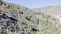
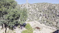
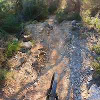
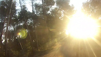
Photos of Sitges Mountain Bike
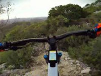
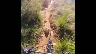
Videos of Sitges Mountain Bike
trail: Can Lluçà
0:21 |
12 |
Feb 21, 2026
trail: Castell de Garraf
0:15 |
3 |
Feb 21, 2026
trail: Cementiri Shortcut
0:47 |
8 |
Jan 3, 2025
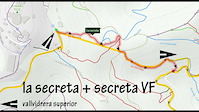
trail: La Secreta
8:58 |
51 |
Jul 12, 2020
trail: De la Creu
6:05 |
238 |
Mar 15, 2014

trail: Les Casetes
28:52 |
51 |
May 13, 2025 , Sitges
trail: La Mola
87 |
May 6, 2025 , Sitges
trail: Serra dels Gegants
6:47 |
73 |
Jan 3, 2025 , Sitges
Current Trail Warnings
| status | trail | date | condition | user | info |
|---|---|---|---|---|---|
| Redbull Cubelles | Jun 28, 2026 @ 12:21pm (Europe/Madrid) Jun 28, 2026 | Dry | NicoNubiola | Destrossada, molta pedra solta,... |
Recent Trail Reports
Activity Feed
| username | action | type | title | date |
|---|---|---|---|---|
| Atzucat | add | report | activity #98247966 and 1 more | Jul 1, 2026 @ 10:25pm 7 hours |
| Galis | update | trail | activity #97991718 | Jun 28, 2026 @ 8:19am Jun 28, 2026 |
| Galis | update | trail | activity #97990221 | Jun 28, 2026 @ 8:02am Jun 28, 2026 |
| Atzucat | difficultyvote | trail | activity #97974558 | Jun 28, 2026 @ 3:48am Jun 28, 2026 |
| NicoNubiola | vote | trail | activity #97973117 | Jun 28, 2026 @ 3:21am Jun 28, 2026 |
Recent Comments
| username | type | title | comment | date |
|---|---|---|---|---|
| trail | Ho deia de pujada tal i com està marcada. En... | May 11, 2026 @ 1:39am May 11, 2026 | ||
| trail | Mucha vegetación y estrecha en la primera... | Apr 22, 2026 @ 11:34am Apr 22, 2026 | ||
| trail | Molt divertits confirmat | Apr 20, 2026 @ 8:47am Apr 20, 2026 | ||
| trail | Al començament del trail hi ha un arbre... | Feb 22, 2026 @ 2:17am Feb 22, 2026 | ||
| trail | La primera part, de pujada fins la creu,... | Jan 16, 2026 @ 11:49am Jan 16, 2026 |
Local Badges
-

Epic Ride Climb 2k138 awarded -

Climbing 10k Badge69 awarded -

Climbing 100k Badge2 awarded -

Epic Ride Descent 2k140 awarded -

Descent 10k Badge69 awarded -

Descent 100k Badge2 awarded
Activity Type Stats
| activitytype | trails | distance | descent | descent distance | total vertical | rating | global rank | state rank | photos | reports | routes | ridelogs |
|---|---|---|---|---|---|---|---|---|---|---|---|---|
| Mountain Bike | 444 | 186 miles | 38,862 ft | 92 miles | 1,854 ft | #374 | #44 | 78 | 1,515 | 4 | 12,793 | |
| E-Bike | 463 | 187 miles | 38,960 ft | 93 miles | 1,854 ft | #102 | #55 | 14 | 1,421 | 3,627 | ||
| Gravel Bike | 1 | #275 | #64 | 2 | 3 | 261 | ||||||
| Adaptive Bike | 27 | #290 | #126 | 1 | ||||||||
| Horse | 12 | 11 miles | 1,503 ft | 4 miles | 879 ft | #1,333 | #99 | 48 | ||||
| Hike | 433 | 179 miles | 37,651 ft | 90 miles | 1,617 ft | #323 | #68 | 1,506 | 692 | |||
| Trail Running | 432 | 178 miles | 37,631 ft | 90 miles | 1,617 ft | #428 | #88 | 1,502 | 1 | 1,925 | ||
| Dirtbike/Moto | 1 | 2 | 47 |
Frequently Asked Questions About Sitges
▼
What are the best places to ride in Sitges?
Sitges has 3 areas to explore for mountain biking. The top rated areas are:
▼
What are the highest rated mountain biking trails in Sitges?
The highest rated mountain biking trails in Sitges are:
- Begues Flow 4 (4.5/5)
- Snail Chaser (4.4/5)
- Els Masets Single (4.4/5)
- Santa Susanna (4.4/5)
- Fondo de les Llenties (4.4/5)
▼
What is the best time of the year to ride in Sitges?
Based on ride log data, the most popular months to ride in Sitges are:
- May (101 activities)
- February (93 activities)
- August (82 activities)
▼
Where can I park to ride in Sitges?
There are 5 parking locations listed in Sitges. The most popular parking spots are: View all parking and trailhead locations on the map to plan your visit.
Activities
Trails
- By coletassoft & contributors
- Admins: snaker4, kai-bcn, henrikenduro, Galis
- #17370 - 5,941 views
- sitges activity log | embed map of Sitges mountain bike trails | sitges mountain biking points of interest polygons
Downloading of trail gps tracks in kml & gpx formats is enabled for Sitges.
You must login to download files.