close
-
Layers w
- Weather Layers
- Pro
- Pro
- Pro
- Pro
- Pro
- Pro
- More Layers
- Pro
- Pro
- Pro
- Pro
-
Upgrade to

3D
Trail Conditions
- Unknown
- Snow Groomed
- Snow Packed
- Snow Covered
- Snow Cover Partial
- Freeze/thaw Cycle
- Icy
- Prevalent Mud
- Wet
- Variable
- Ideal
- Dry
- Very Dry
Trail Flow (Ridden Direction)
Trailforks scans users ridelogs to determine the most popular direction each trail is ridden. A good flowing trail network will have most trails flowing in a single direction according to their intension.
The colour categories are based on what percentage of riders are riding a trail in its intended direction.
The colour categories are based on what percentage of riders are riding a trail in its intended direction.
- > 96%
- > 90%
- > 80%
- > 70%
- > 50%
- < 50%
- bi-directional trail
- no data
Trail Last Ridden
Trailforks scans ridelogs to determine the last time a trail was ridden.
- < 2 days
- < 1 week
- < 2 weeks
- < 1 month
- < 6 months
- > 6 months
Trail Ridden Direction
The intended direction a trail should be ridden.
- Downhill Only
- Downhill Primary
- Both Directions
- Uphill Primary
- Uphill Only
- One Direction
Contribute Details
Colors indicate trail is missing specified detail.
- Description
- Photos
- Description & Photos
- Videos
Trail Popularity ?
Trailforks scans ridelogs to determine which trails are ridden the most in the last 9 months.
Trails are compared with nearby trails in the same city region with a possible 25 colour shades.
Think of this as a heatmap, more rides = more kinetic energy = warmer colors.
- most popular
- popular
- less popular
- not popular
ATV/ORV/OHV Filter
Max Vehicle Width
inches
US Cell Coverage
Legend

Radar Time
Activity Recordings
Trailforks uses anonymized public activity data.
?
Activity Recordings
Trailforks uses anonymized public activity data.
?
Personal Heatmap
▶
Activity Types
all
/
none
▶
Options
2
Date range
month
–
Winter Trails
Warning
A routing network for winter maps does not exist. Selecting trails using the winter trails layer has been disabled.
Missing Trails
Most Popular
Least Popular
Trails are colored based on popularity. The more popular a trail is, the more red. Less popular trails trend towards green.
Jump Magnitude Heatmap
Heatmap of where riders jump on trails. Zoom in to see individual jumps, click circles to view jump details.
BC Backroad Status
![map legend]()
Service Road Atlas is a free to use, community-driven service for viewing and creating reports on the numerous back-country service roads around B.C. and Alberta.

Slope Aspect
Direction the slope faces
Trails Deemphasized
Trails are shown in grey.
Only show trails with no bike usage.
Suggested Layers
Based on selected activity type
Save the current map location and zoom level as your default home location whenever this page is loaded.
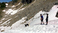
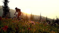
SaveSol Mountain backcountry lodge offers alpine singletrack mountain biking just south of Revelstoke, in British Columbia’s Monashee Mountains. Open, flowy singletrack threading through alpine meadows and tons of technical slabrock features for all you XC and All Mountain riders. Sol Mountain is accessed in the summer by a two and half hour drive from Revelstoke, BC.
Day use welcome. Visitors please park outside of our Guest parking lot and ride in. Trail donations accepted at the lodge and include a complimentary cold beer in Sol Lake NO DOGS permitted in Monashee Park.
All trails open August 1 depending on snow melt.
Contact the office [email protected] for details.
Primary Trail Type: Cross-Country
Land Status: Crown Land
 google parking directions
 Access Info:
It is 55 km of bumpy logging road from Shelter Bay – be sure your bike is secure! All junctions are signed. Some hitch and roof mount racks are not be adequate – inside the vehicle may be better. From our guest parking lot it is a two km ride to the lodge winding through the subalpine forest and open meadows.
Links
Files
- Sol_Bike_Trails.pdf (402 KB)
Activities Click to view
- Mountain Bike
20 trails
- E-Bike
20 trails
- Hike
2 trails
- Trail Running
1 trails
Region Details
- 1
- 5
- 8
- 6
Region Status
Closed as of Jul 7, 2026Stats
- Avg Trail Rating
- Trails (view details)
- 20
- Trails Mountain Bike
- 20
- Trails E-Bike
- 20
- Trails Hike
- 2
- Trails Trail Running
- 1
- Total Distance
- 18 miles
- Total Descent
- 4,466 ft
- Total Vertical
- 1,320 ft
- Highest Trailhead
- 7,306 ft
- Reports
- 623
- Photos
- 288
- Ridden Counter
- 3,734
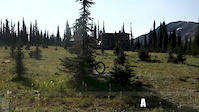
Sol Mountain Mountain Bike Routes
• 14 miles • 2,144 ft • 8 •
• 17 miles • 2,988 ft • 14 •
• 17 miles • 3,281 ft • 13 •
• 8 miles • 1,764 ft • 6 •
• 12 miles • 2,244 ft • 9 •
Photos of Sol Mountain Mountain Bike
Videos of Sol Mountain Mountain Bike

trail: Beyond
0:05 |
|
Jul 23, 2023

trail: Beyond
0:15 |
|
Jul 21, 2023

trail: Infinity
0:07 |
|
Oct 10, 2022
trail: South Caribou Pass
4:54 |
1989 |
Nov 17, 2017
trail: South Caribou Pass
2:18 |
2628 |
Sep 27, 2017
trail: South Caribou Pass
2:22 |
7005 |
Aug 11, 2017

trail: Crazee Train
2:24 |
|
Aug 25, 2015

trail: Crazee Train
2:24 |
|
Aug 25, 2015
Recent Trail Reports
| status | trail | date | condition | info | user |
|---|---|---|---|---|---|
| West Loop | Oct 28, 2025 @ 11:15am (America/Vancouver) Oct 28, 2025 | Snow Covered | solmountain WGOC | ||
| South Caribou Pass | Oct 28, 2025 @ 11:15am (America/Vancouver) Oct 28, 2025 | Snow Covered | solmountain WGOC | ||
| Sol Road | Oct 28, 2025 @ 11:15am (America/Vancouver) Oct 28, 2025 | Snow Covered | solmountain WGOC | ||
| Sol Lake | Oct 28, 2025 @ 11:15am (America/Vancouver) Oct 28, 2025 | Snow Covered | solmountain WGOC | ||
| Sassy Toe | Oct 28, 2025 @ 11:15am (America/Vancouver) Oct 28, 2025 | Snow Covered | solmountain WGOC | ||
| Ridge | Oct 28, 2025 @ 11:15am (America/Vancouver) Oct 28, 2025 | Snow Covered | solmountain WGOC | ||
| Ridge | Oct 28, 2025 @ 11:15am (America/Vancouver) Oct 28, 2025 | Snow Covered | solmountain WGOC | ||
| Pussy Toe Loop | Oct 28, 2025 @ 11:15am (America/Vancouver) Oct 28, 2025 | Snow Covered | solmountain WGOC | ||
| Park N Ride | Oct 28, 2025 @ 11:15am (America/Vancouver) Oct 28, 2025 | Snow Covered | solmountain WGOC | ||
| Mount Fosthall Route | Oct 28, 2025 @ 11:15am (America/Vancouver) Oct 28, 2025 | Snow Covered | solmountain WGOC |
Activity Feed
| username | action | type | title | date |
|---|---|---|---|---|
| Megans2186 | wishlist | region | activity #94904414 | May 17, 2026 @ 8:10am May 17, 2026 |
| Bayleigh | ridden | trail | activity #94753089 | May 15, 2026 @ 9:00am May 15, 2026 |
| solmountain | comment | report | activity #94699995 | May 14, 2026 @ 10:42am May 14, 2026 |
| ShamusUgXSkw | ridden | trail | activity #92022469 | Apr 5, 2026 @ 6:36pm Apr 5, 2026 |
| mtbCrazy1990 | wishlist | region | activity #91742960 | Apr 1, 2026 @ 8:34pm Apr 1, 2026 |
Recent Comments
| username | type | title | comment | date |
|---|---|---|---|---|
| report | We agree! Thank Guy | May 14, 2026 @ 10:42am May 14, 2026 | ||
| report | This is a fun flow trail with drops, pops and... | Sep 10, 2025 @ 7:16am Sep 10, 2025 | ||
| trail | Glad you like it - we think so too ! | Aug 25, 2023 @ 8:07am Aug 25, 2023 | ||
| trail | One of the best trails I have ever ridden! An... | Jul 29, 2023 @ 8:39pm Jul 29, 2023 | ||
| trail | No - the trails do not connect. Mountain... | Jul 21, 2023 @ 10:50am Jul 21, 2023 |
Nearby Areas
| name | distance | ||||
|---|---|---|---|---|---|
| Mt. Abriel | 8 | 27 | 16 | 5 | 17.5 km |
| Box Lake | 1 | 3 | 3 | 26.5 km | |
| Joss Mountain | 28.3 km | ||||
| Cartier | 1 | 32.1 km | |||
| Sunnyside | 3 | 33.2 km |
Activity Type Stats
| activitytype | trails | distance | descent | descent distance | total vertical | rating | global rank | state rank | photos | reports | routes | ridelogs |
|---|---|---|---|---|---|---|---|---|---|---|---|---|
| Mountain Bike | 20 | 18 miles | 4,465 ft | 9 miles | 1,319 ft | #3,390 | #156 | 287 | 621 | 1 | 832 | |
| E-Bike | 20 | 18 miles | 4,465 ft | 9 miles | 1,319 ft | #4,402 | #170 | 278 | 15 | |||
| Hike | 2 | 3 miles | 1,401 ft | 2 miles | 1,004 ft | #13,199 | #469 | 613 | 109 | |||
| Trail Running | 1 | 1 mile | 909 ft | 1 mile | 886 ft | #13,387 | #465 | 611 | 28 |
Frequently Asked Questions About Sol Mountain
▼
What are the highest rated mountain biking trails in Sol Mountain?
The highest rated mountain biking trails in Sol Mountain are:
- Beyond (4.4/5)
- Infinity (4.4/5)
- Beacon Check (4.4/5)
- Ridge (4.4/5)
- Ridge (4.4/5)
▼
What is the best time of the year to ride in Sol Mountain?
Based on ride log data, the most popular months to ride in Sol Mountain are:
- August (39 activities)
- September (26 activities)
- July (3 activities)
▼
Where can I park to ride in Sol Mountain?
There are 1 parking locations listed in Sol Mountain. The most popular parking spots are:
▼
What is the longest trail in Sol Mountain?
The longest trail in Sol Mountain is South Caribou Pass at 2.2 miles. View all trails sorted by distance.
- By canadaka
 Trailforks & contributors
 - Admins: RCA, RNSC, solmountain
- #4200 - 28,093 views
- sol mountain activity log | embed map of Sol Mountain mountain bike trails | sol mountain mountain biking points of interest
Downloading of trail gps tracks in kml & gpx formats is enabled for Sol Mountain.
You must login to download files.