close
-
Layers w
- Weather Layers
- Pro
- Pro
- Pro
- Pro
- Pro
- Pro
- More Layers
- Pro
- Pro
- Pro
- Pro
-
Upgrade to

3D
Trail Conditions
- Unknown
- Snow Groomed
- Snow Packed
- Snow Covered
- Snow Cover Partial
- Freeze/thaw Cycle
- Icy
- Prevalent Mud
- Wet
- Variable
- Ideal
- Dry
- Very Dry
Trail Flow (Ridden Direction)
Trailforks scans users ridelogs to determine the most popular direction each trail is ridden. A good flowing trail network will have most trails flowing in a single direction according to their intension.
The colour categories are based on what percentage of riders are riding a trail in its intended direction.
The colour categories are based on what percentage of riders are riding a trail in its intended direction.
- > 96%
- > 90%
- > 80%
- > 70%
- > 50%
- < 50%
- bi-directional trail
- no data
Trail Last Ridden
Trailforks scans ridelogs to determine the last time a trail was ridden.
- < 2 days
- < 1 week
- < 2 weeks
- < 1 month
- < 6 months
- > 6 months
Trail Ridden Direction
The intended direction a trail should be ridden.
- Downhill Only
- Downhill Primary
- Both Directions
- Uphill Primary
- Uphill Only
- One Direction
Contribute Details
Colors indicate trail is missing specified detail.
- Description
- Photos
- Description & Photos
- Videos
Trail Popularity ?
Trailforks scans ridelogs to determine which trails are ridden the most in the last 9 months.
Trails are compared with nearby trails in the same city region with a possible 25 colour shades.
Think of this as a heatmap, more rides = more kinetic energy = warmer colors.
- most popular
- popular
- less popular
- not popular
ATV/ORV/OHV Filter
Max Vehicle Width
inches
US Cell Coverage
Legend

Radar Time
Activity Recordings
Trailforks uses anonymized public activity data.
?
Activity Recordings
Trailforks uses anonymized public activity data.
?
Personal Heatmap
▶
Activity Types
all
/
none
▶
Options
2
Date range
month
–
Winter Trails
Warning
A routing network for winter maps does not exist. Selecting trails using the winter trails layer has been disabled.
Missing Trails
Most Popular
Least Popular
Trails are colored based on popularity. The more popular a trail is, the more red. Less popular trails trend towards green.
Jump Magnitude Heatmap
Heatmap of where riders jump on trails. Zoom in to see individual jumps, click circles to view jump details.
BC Backroad Status
![map legend]()
Service Road Atlas is a free to use, community-driven service for viewing and creating reports on the numerous back-country service roads around B.C. and Alberta.

Slope Aspect
Direction the slope faces
Trails Deemphasized
Trails are shown in grey.
Only show trails with no bike usage.
Suggested Layers
Based on selected activity type
Save the current map location and zoom level as your default home location whenever this page is loaded.
SaveRyssberget MTB
This region uses the Uk/Euro style trail grading system.
Activities Click to view
- Mountain Bike
59 trails
- Gravel Bike
0 trails
- Adaptive Bike
0 trails
- Hike
67 trails
- Trail Running
67 trails
Region Details
- 10
- 10
- 36
- 3
Region Status
Open as of Jul 13, 2025Stats
- Avg Trail Rating
- Trails (view details)
- 67
- Trails Mountain Bike
- 59
- Trails Horse
- 1
- Trails Hike
- 67
- Trails Trail Running
- 67
- Total Distance
- 31 miles
- Total Descent
- 6,474 ft
- Total Vertical
- 473 ft
- Highest Trailhead
- 498 ft
- Reports
- 92
- Photos
- 14
- Ridden Counter
- 3,129
Sub Regions
-
Hjortakroken
- 1
-
Ryssberget
- 8
- 35
- 3
Popular Sölvesborg Mountain Biking Trails
• 60 ★ 4.5 • 1 mile • 54 ft • 179 •
Moderately popular blue difficulty singletrack. This multi-use trail can be used both directions and has a moderate overall physical rating with a 54 ft blue climb. On average it takes 6 minutes to complete this trail.
• 95 ★ 5.0 • 3,320 ft • 0 ft • 119 •
Popular blue difficulty singletrack. This multi-use trail can be used downhill primary and has a moderate overall physical rating with a 0 ft black diamond climb. It features drop, jump and ladder bridge. On average it takes 4 minutes to complete this trail.
• 65 ★ 3.4 • 1,791 ft • 0 ft • 116 •
Moderately popular red difficulty mixed. This multi-use trail can be used downhill primary and has a moderate overall physical rating with a 0 ft black diamond climb. It features berm, drop and jump. On average it takes 5 minutes to complete this trail.
• 50 ★ 4.5 • 2,657 ft • 0 ft • 115 •
Moderately popular blue difficulty singletrack. This multi-use trail can be used downhill primary and has a moderate overall physical rating with a 0 ft blue climb. On average it takes 4 minutes to complete this trail.
• 100 ★ 5.0 • 3,904 ft • 2 ft • 107 •
Ryssberget underbara flowtrail. Passar alla Ta grusvägen upp. Hoppa på leden där det passaar och njut. Allt går att rulla men det finns gått om exta för den som kan och vågar.
• 40 ★ 0.0 • 1,079 ft • 0 ft • 103 •
Moderately popular blue difficulty singletrack. This multi-use trail can be used downhill primary and has a moderate overall physical rating with a 0 ft blue climb. On average it takes 1 minutes to complete this trail.
• 40 ★ 4.0 • 1,670 ft • 0 ft • 103 •
Moderately popular blue difficulty singletrack. This multi-use trail can be used downhill primary and has a moderate overall physical rating with a 0 ft black diamond climb. It features berm and rock garden. On average it takes 3 minutes to complete this trail.
• 45 ★ 0.0 • 1,106 ft • 0 ft • 95 •
Moderately popular blue difficulty singletrack. This multi-use trail can be used downhill primary and has a moderate overall physical rating with a 0 ft blue climb. On average it takes 1 minutes to complete this trail.
Sölvesborg Mountain Bike Routes
19 miles • 2,045 ft • 1 • Point to Point •
Skåneleden mellan Ljungryda och Sölvesborg Blandat mellan Singeltracks och grusvägar. En trevlig tur...
1 mile • 67 ft • 3 • Point to Point •
Beskrivande text. Beskrivande text. Beskrivande text.
Photos of Sölvesborg Mountain Bike
Videos of Sölvesborg Mountain Bike
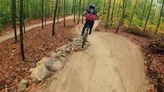
trail: Sparbanksstigen
4:39 |
477 |
Jan 14, 2023 , Sölvesborg
Recent Trail Reports
| status | trail | date | condition | info | user |
|---|---|---|---|---|---|
| Flowtrail | Jul 13, 2025 @ 10:36am Jul 13, 2025 | Ideal | johanlarsson123 | ||
| Jockarpsbranten | Mar 29, 2025 @ 10:33am Mar 29, 2025 | Ideal | MagnusWengelin | ||
| Krattan | Mar 29, 2025 @ 10:33am Mar 29, 2025 | Ideal | MagnusWengelin | ||
| Gränsbranten | Mar 29, 2025 @ 10:33am Mar 29, 2025 | Variable | MagnusWengelin | ||
| Norra Länken | Mar 29, 2025 @ 10:33am Mar 29, 2025 | Ideal | MagnusWengelin | ||
| Kåtan | Mar 29, 2025 @ 10:33am Mar 29, 2025 | Ideal | MagnusWengelin | ||
| The Beast | Mar 29, 2025 @ 10:33am Mar 29, 2025 | Ideal | MagnusWengelin | ||
| Deadwood | Mar 29, 2025 @ 10:33am Mar 29, 2025 | Dry | MagnusWengelin | ||
| Vita Stigen | Dec 7, 2024 @ 2:15pm Dec 7, 2024 | Variable | AnBorgman | ||
| Sparbanksstigen | Aug 29, 2024 @ 5:51pm Aug 29, 2024 | Ideal | AnBorgman |
Activity Feed
| username | action | type | title | date |
|---|---|---|---|---|
| gujo82 | wishlist | route | activity #84885395 | Nov 28, 2025 @ 11:03pm Nov 28, 2025 |
| johanlarsson123 | add | report | activity #75834471 | Jul 13, 2025 @ 10:36am Jul 13, 2025 |
| johanlarsson123 | ridden | trail | activity #75827679 | Jul 13, 2025 @ 9:30am Jul 13, 2025 |
| Helen7iFy7F | vote | trail | activity #75215920 | Jul 4, 2025 @ 11:40pm Jul 4, 2025 |
| Roq | comment | trail | activity #74721025 | Jun 28, 2025 @ 5:42am Jun 28, 2025 |
Recent Comments
| username | type | title | comment | date |
|---|---|---|---|---|
| trail | Superbra! Funkar för alla. Någon kraftigare... | Jun 28, 2025 @ 5:42am Jun 28, 2025 | ||
| trail | Too much fun! Very natural unrefined rocky ... | Aug 6, 2024 @ 4:46pm Aug 6, 2024 | ||
| trail | Fun trail at speed. Rocks n, roots with loads... | Aug 6, 2024 @ 4:41pm Aug 6, 2024 | ||
| trail | Nice xc single track, rocky fun, but missing... | Aug 4, 2024 @ 12:22pm Aug 4, 2024 | ||
| trail | Well made fun trail, my 7 year old could not... | Aug 4, 2024 @ 12:17pm Aug 4, 2024 |
Local Badges
-

Epic Ride Climb 2k1 awarded -

Climbing 10k Badge14 awarded -

Climbing 100k Badge1 awarded -

Epic Ride Descent 2k1 awarded -

Descent 10k Badge14 awarded -

Descent 100k Badge1 awarded
Bike & Skill Parks
| name | type | city | rating |
|---|---|---|---|
| Velosolutions pumptrack | skill park | Sölvesborg |
Activity Type Stats
| activitytype | trails | distance | descent | descent distance | total vertical | rating | global rank | state rank | photos | reports | routes | ridelogs |
|---|---|---|---|---|---|---|---|---|---|---|---|---|
| Mountain Bike | 59 | 26 miles | 6,014 ft | 17 miles | 472 ft | #3,546 | #122 | 14 | 92 | 2 | 4,892 | |
| Horse | 1 | 1 mile | 26 ft | 974 ft | 276 ft | 28 | ||||||
| Hike | 67 | 31 miles | 6,473 ft | 18 miles | 472 ft | #4,246 | #134 | 90 | 107 | |||
| Trail Running | 67 | 31 miles | 6,473 ft | 18 miles | 472 ft | 90 | 148 |
Frequently Asked Questions About Sölvesborg
▼
What are the best places to ride in Sölvesborg?
Sölvesborg has 2 areas to explore for mountain biking. The top rated areas are:
▼
What are the highest rated mountain biking trails in Sölvesborg?
The highest rated mountain biking trails in Sölvesborg are:
- Flowtrail (4.4/5)
- Cherry Hill (4.2/5)
- Röd-Vit Snitzel (4.2/5)
- Deadwood (4.1/5)
- Pineapple Express (4.1/5)
▼
What is the best time of the year to ride in Sölvesborg?
Based on ride log data, the most popular months to ride in Sölvesborg are:
- July (65 activities)
- May (53 activities)
- April (29 activities)
▼
Where can I park to ride in Sölvesborg?
Check the Sölvesborg trail map for trailhead and parking information. Community members regularly update access and parking details for trails in the area.
- By JALLE
 & contributors
 - Admins: ollesvenskonthetrail, JALLE, martinlindstr, JALLE
- #13495 - 4,563 views
- sölvesborg activity log | embed map of Sölvesborg mountain bike trails | sölvesborg mountain biking points of interest
Downloading of trail gps tracks in kml & gpx formats is enabled for Sölvesborg.
You must login to download files.