close
-
Layers w
- Weather Layers
- Pro
- Pro
- Pro
- Pro
- Pro
- Pro
- More Layers
- Pro
- Pro
- Pro
- Pro
-
Upgrade to

3D
Trail Conditions
- Unknown
- Snow Groomed
- Snow Packed
- Snow Covered
- Snow Cover Partial
- Freeze/thaw Cycle
- Icy
- Prevalent Mud
- Wet
- Variable
- Ideal
- Dry
- Very Dry
Trail Flow (Ridden Direction)
Trailforks scans users ridelogs to determine the most popular direction each trail is ridden. A good flowing trail network will have most trails flowing in a single direction according to their intension.
The colour categories are based on what percentage of riders are riding a trail in its intended direction.
The colour categories are based on what percentage of riders are riding a trail in its intended direction.
- > 96%
- > 90%
- > 80%
- > 70%
- > 50%
- < 50%
- bi-directional trail
- no data
Trail Last Ridden
Trailforks scans ridelogs to determine the last time a trail was ridden.
- < 2 days
- < 1 week
- < 2 weeks
- < 1 month
- < 6 months
- > 6 months
Trail Ridden Direction
The intended direction a trail should be ridden.
- Downhill Only
- Downhill Primary
- Both Directions
- Uphill Primary
- Uphill Only
- One Direction
Contribute Details
Colors indicate trail is missing specified detail.
- Description
- Photos
- Description & Photos
- Videos
Trail Popularity ?
Trailforks scans ridelogs to determine which trails are ridden the most in the last 9 months.
Trails are compared with nearby trails in the same city region with a possible 25 colour shades.
Think of this as a heatmap, more rides = more kinetic energy = warmer colors.
- most popular
- popular
- less popular
- not popular
ATV/ORV/OHV Filter
Max Vehicle Width
inches
US Cell Coverage
Legend

Radar Time
Activity Recordings
Trailforks uses anonymized public activity data.
?
Activity Recordings
Trailforks uses anonymized public activity data.
?
Personal Heatmap
▶
Activity Types
all
/
none
▶
Options
2
Date range
month
–
Winter Trails
Warning
A routing network for winter maps does not exist. Selecting trails using the winter trails layer has been disabled.
Missing Trails
Most Popular
Least Popular
Trails are colored based on popularity. The more popular a trail is, the more red. Less popular trails trend towards green.
Jump Magnitude Heatmap
Heatmap of where riders jump on trails. Zoom in to see individual jumps, click circles to view jump details.
BC Backroad Status
![map legend]()
Service Road Atlas is a free to use, community-driven service for viewing and creating reports on the numerous back-country service roads around B.C. and Alberta.

Slope Aspect
Direction the slope faces
Trails Deemphasized
Trails are shown in grey.
Only show trails with no bike usage.
Suggested Layers
Based on selected activity type
Save the current map location and zoom level as your default home location whenever this page is loaded.
Save
No description for Sterzing has been added yet!
Login or register to submit one.
eBikes Allowed:
Yes
AKA: Vipiteno
This region uses the Uk/Euro style trail grading system.
Activities Click to view
- Mountain Bike
13 trails
- E-Bike
12 trails
- Adaptive Bike
0 trails
- Hike
14 trails
- Trail Running
13 trails
- Downhill Ski
47 trails
Region Details
- 4
- 1
- 6
- 2
Region Status
Open as of Aug 13, 2025Stats
- Avg Trail Rating
- Trails (view details)
- 62
- Trails Mountain Bike
- 13
- Trails E-Bike
- 12
- Trails Hike
- 14
- Trails Trail Running
- 13
- Trails Downhill Ski
- 47
- Total Distance
- 63 miles
- Total Descent Distance
- 51 miles
- Total Descent
- 51,304 ft
- Total Vertical
- 5,287 ft
- Highest Trailhead
- 8,451 ft
- Reports
- 27
- Photos
- 39
- Ridden Counter
- 640
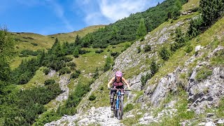
Popular Sterzing Mountain Biking Trails
• 100 ★ 4.0 • 3 miles • 0 ft • 59 •
Alpine single track, mostly flowy and fast, with some easy rocky section Amazing view and landscape.
• 85 ★ 3.4 • 2 miles • 49 ft • 20 •
Great alpine single-trail on natural ground with a few technical sections (but not that hard). Switchback-skills are not that necessary. No roots, only a few rocks are in the track. 100% stunning landscape views during your ride :-)...
• 60 ★ 4.5 • 2 miles • 19 ft • 16 •
Nice single-trail on natural ground with a few roots. Switchback-skills are not that necessary, most of them the curves are easy rideable. No big tech-skills required. The first few metres at Grubbergalm/Malga Grubberg are...
• 70 ★ 0.0 • 2 miles • 1,015 ft • 14 •
Schotter Uphill zum Schlüsselhoch, nur letztes Stück ein Singletrack, davor Doubletrack Teilweise steiler, aber auch noch für Biobikes im Uphill fahrbar. Wird sowohl Uphill, als auch Downhill gefahren
• 5 ★ 3.8 • 2 miles • 91 ft • 11 •
Ride down from back to Brenner. Start from Brenner or for overnight tour from Zillertal or Pfitscherjoch
• 35 ★ 4.0 • 1 mile • 0 ft • 11 •
Single Trail down from Enzianhütte to Brennerbad. Begins over a meadow, then heads into the forest with some tight switchbacks and tight forest sections. Steep throughout and becomes even more challenging after Badalm. Bottom section...
• 25 ★ 4.0 • 2 miles • 0 ft • 10 •
Please keep in mind that this trail is also a hiking path – be friendly and respectful. Ride with care!!! Easy and wide alpine flow track on natural ground from Steinjoch (Monte Sasso) to Stein-Alm (Malga Sasso). Just follow signs...
• 5 ★ 0.0 • 2,349 ft • 29 ft • 7 • • hike
Leichter Trail als Abkürzung für die Straße. Abgesehen von den Stufen kurz nach Beginn sehr leicht fahrbar (grün)
Photos of Sterzing Mountain Bike
Videos of Sterzing Mountain Bike
trail: The Portal
23:46 |
81 |
Jul 2, 2024 , Sterzing
Recent Trail Reports
| status | trail | date | condition | info | user |
|---|---|---|---|---|---|
| Enzianhütte Trail | Aug 13, 2025 @ 4:50am Aug 13, 2025 | Dry | gruwolf | ||
| Novale | Aug 9, 2025 @ 9:13am Aug 9, 2025 | Ideal | andreac4 | ||
| Grubberg-Trail | Sep 7, 2023 @ 1:10am Sep 7, 2023 | Ideal | Nasopanic | ||
| Trail Flatschjoch / Passo di Vallaccia | Sep 7, 2023 @ 1:07am Sep 7, 2023 | Ideal | Nasopanic | ||
| Access Flatschjoch / Passo di Vallaccia | Sep 7, 2023 @ 1:05am Sep 7, 2023 | Dry | Nasopanic | ||
| Schlüsseljoch | Sep 7, 2023 @ 12:59am Sep 7, 2023 | Ideal | Nasopanic | ||
| Pfunderer Joch | Jun 26, 2022 @ 11:50pm Jun 26, 2022 | Dry | tomir77 | ||
| Steinalm Trail | Jul 27, 2021 @ 9:56am Jul 27, 2021 | Wet | Mad-Dogg |
Activity Feed
| username | action | type | title | date |
|---|---|---|---|---|
| fekko | add | trail | activity #96466513 | Jun 7, 2026 @ 8:52am Jun 7, 2026 |
| floete | ridden | trail | activity #94635452 and 1 more | May 13, 2026 @ 10:14am May 13, 2026 |
| AndreasPJ83 | wishlist | trail | activity #91006573 and 2 more | Mar 21, 2026 @ 10:58am Mar 21, 2026 |
| UDRHdV | wishlist | trail | activity #87466021 | Jan 19, 2026 @ 5:04am Jan 19, 2026 |
| Dominicx50U3u | wishlist | region | activity #84450168 | Nov 20, 2025 @ 11:48am Nov 20, 2025 |
Recent Comments
| username | type | title | comment | date |
|---|---|---|---|---|
| trail | Hier ein schöne Beschreibung von einem... | Jun 23, 2025 @ 4:39am Jun 23, 2025 | ||
| trail | Hier eine schöne Beschreibung zum Trail... | Jun 23, 2025 @ 4:37am Jun 23, 2025 | ||
| trail | Hier eine schöne Beschreibung zum Weg... | Jun 23, 2025 @ 4:36am Jun 23, 2025 | ||
| trail | Guidelines: Thanks!, I found it myself in the... | Sep 3, 2024 @ 11:59am Sep 3, 2024 | ||
| trail | TF Guidelines can be found at this link:... | Sep 3, 2024 @ 11:30am Sep 3, 2024 |
Local Badges
-

Epic Mountain Bike Climb 2k5 awarded -

Climbing 10k Badge0 awarded -

Mountain Biking 100k Badge0 awarded -

Epic Ride Descent 2k5 awarded -

Descent 10k Badge0 awarded -

Descent 100k Badge0 awarded
Activity Type Stats
| activitytype | trails | distance | descent | descent distance | total vertical | rating | global rank | state rank | photos | reports | routes | ridelogs |
|---|---|---|---|---|---|---|---|---|---|---|---|---|
| Mountain Bike | 13 | 27 miles | 12,470 ft | 16 miles | 4,186 ft | #5,645 | #432 | 39 | 13 | 457 | ||
| E-Bike | 12 | 24 miles | 12,438 ft | 16 miles | 4,186 ft | #3,511 | #328 | 11 | 77 | |||
| Hike | 14 | 33 miles | 18,287 ft | 22 miles | 4,580 ft | #5,741 | #271 | 13 | 305 | |||
| Trail Running | 13 | 32 miles | 16,512 ft | 21 miles | 4,580 ft | #5,576 | #287 | 11 | 4 | |||
| Downhill Ski | 47 | 30 miles | 33,018 ft | 30 miles | 3,835 ft | #233 | #21 | 14 | 270 |
Frequently Asked Questions About Sterzing
▼
What are the best places to ride in Sterzing?
Sterzing has 3 areas to explore for mountain biking.
▼
What are the highest rated mountain biking trails in Sterzing?
The highest rated mountain biking trails in Sterzing are:
- Grubberg-Trail (4.1/5)
- Pfunderer Joch (4/5)
- Enzianhütte Trail (4/5)
- Steinalm Trail (4/5)
- Schlüsseljoch (3.9/5)
▼
What is the best time of the year to ride in Sterzing?
Based on ride log data, the most popular months to ride in Sterzing are:
- July (13 activities)
- September (8 activities)
- August (4 activities)
▼
Where can I park to ride in Sterzing?
Check the Sterzing trail map for trailhead and parking information. Community members regularly update access and parking details for trails in the area.
Activities
Trails
- By torolococarajo & contributors
- Admins: caval, larry81541, micheletraversi
- #31326 - 2,141 views
- sterzing activity log | embed map of Sterzing mountain bike trails | sterzing mountain biking points of interest
Downloading of trail gps tracks in kml & gpx formats is enabled for Sterzing.
You must login to download files.