close
-
Layers w
- Weather Layers
- Pro
- Pro
- Pro
- Pro
- Pro
- Pro
- More Layers
- Pro
- Pro
- Pro
- Pro
-
Upgrade to

3D
Trail Conditions
- Unknown
- Snow Groomed
- Snow Packed
- Snow Covered
- Snow Cover Partial
- Freeze/thaw Cycle
- Icy
- Prevalent Mud
- Wet
- Variable
- Ideal
- Dry
- Very Dry
Trail Flow (Ridden Direction)
Trailforks scans users ridelogs to determine the most popular direction each trail is ridden. A good flowing trail network will have most trails flowing in a single direction according to their intension.
The colour categories are based on what percentage of riders are riding a trail in its intended direction.
The colour categories are based on what percentage of riders are riding a trail in its intended direction.
- > 96%
- > 90%
- > 80%
- > 70%
- > 50%
- < 50%
- bi-directional trail
- no data
Trail Last Ridden
Trailforks scans ridelogs to determine the last time a trail was ridden.
- < 2 days
- < 1 week
- < 2 weeks
- < 1 month
- < 6 months
- > 6 months
Trail Ridden Direction
The intended direction a trail should be ridden.
- Downhill Only
- Downhill Primary
- Both Directions
- Uphill Primary
- Uphill Only
- One Direction
Contribute Details
Colors indicate trail is missing specified detail.
- Description
- Photos
- Description & Photos
- Videos
Trail Popularity ?
Trailforks scans ridelogs to determine which trails are ridden the most in the last 9 months.
Trails are compared with nearby trails in the same city region with a possible 25 colour shades.
Think of this as a heatmap, more rides = more kinetic energy = warmer colors.
- most popular
- popular
- less popular
- not popular
ATV/ORV/OHV Filter
Max Vehicle Width
inches
US Cell Coverage
Legend

Radar Time
Activity Recordings
Trailforks uses anonymized public activity data.
?
Activity Recordings
Trailforks uses anonymized public activity data.
?
Personal Heatmap
▶
Activity Types
all
/
none
▶
Options
2
Date range
month
–
Winter Trails
Warning
A routing network for winter maps does not exist. Selecting trails using the winter trails layer has been disabled.
Missing Trails
Most Popular
Least Popular
Trails are colored based on popularity. The more popular a trail is, the more red. Less popular trails trend towards green.
Jump Magnitude Heatmap
Heatmap of where riders jump on trails. Zoom in to see individual jumps, click circles to view jump details.
BC Backroad Status
![map legend]()
Service Road Atlas is a free to use, community-driven service for viewing and creating reports on the numerous back-country service roads around B.C. and Alberta.

Slope Aspect
Direction the slope faces
Trails Deemphasized
Trails are shown in grey.
Only show trails with no bike usage.
Suggested Layers
Based on selected activity type
Save the current map location and zoom level as your default home location whenever this page is loaded.
Save
No description for Tempe has been added yet!
Login or register to submit one.
Activities Click to view
- Mountain Bike
114 trails
- E-Bike
26 trails
- Gravel Bike
7 trails
- Adaptive Bike
0 trails
- Hike
112 trails
- Trail Running
112 trails
Region Details
- 23
- 15
- 64
- 9
- 2
Region Status
Open as of May 19, 2026Local Trail Association
Stats
- Avg Trail Rating
- Trails (view details)
- 116
- Trails Mountain Bike
- 116
- Trails E-Bike
- 26
- Trails Gravel Bike
- 7
- Trails Horse
- 1
- Trails Hike
- 112
- Trails Trail Running
- 112
- Total Distance
- 59 miles
- Total Descent
- 2,303 ft
- Total Vertical
- 316 ft
- Highest Trailhead
- 1,448 ft
- Reports
- 467
- Photos
- 100
- Ridden Counter
- 30,832
Articles
Video: Brice Shirbach Heads Home to Tempe, Arizona in 'Underexposed'
Mar 24, 2026 from pinkbike.com
In the kickoff to the final season, Brice explores the rugged desert trails and advocacy efforts that serve as the literal testing ground for...
Sub Regions
-
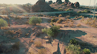
Papago Park
- 4
- 61
- 9
- 2
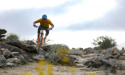
Popular Tempe Mountain Biking Trails
• 100 ★ 1.4 • 1,020 ft • 3 ft • 948 •
Popular green difficulty singletrack. This multi-use trail can be used both directions. On average it takes 1 minutes to complete this trail.
• 100 ★ 2.0 • 938 ft • 28 ft • 809 •
Popular green difficulty singletrack. This multi-use trail can be used both directions. On average it takes 2 minutes to complete this trail.
• 90 ★ 3.7 • 4,191 ft • 70 ft • 692 •
Popular green difficulty singletrack. This multi-use trail can be used both directions and has a easy overall physical rating with a 70 ft green climb. On average it takes 5 minutes to complete this trail.
• 90 ★ 0.0 • 486 ft • 0 ft • 592 •
Popular green difficulty singletrack. This multi-use trail can be used both directions. On average it takes 1 minutes to complete this trail.
• 65 ★ 4.0 • 5,138 ft • 73 ft • 533 •
Moderately popular blue difficulty singletrack. This multi-use trail can be used both directions. On average it takes 6 minutes to complete this trail.
• 70 ★ 2.0 • 240 ft • 0 ft • 503 •
Popular green difficulty singletrack. This multi-use trail can be used both directions. On average it takes minutes to complete this trail.
• 70 ★ 3.0 • 3,494 ft • 60 ft • 490 •
Popular green difficulty singletrack. This multi-use trail can be used both directions. On average it takes 5 minutes to complete this trail.
Tempe Mountain Bike Routes
★ 3.5 • 16 miles • 2,569 ft • 6 • Point to Point •
The complete South Mountain National trail, plus RidgeLine. This keeps you at the top of the whole middle...
9 miles • 1,408 ft • 12 • Loop •
This is one of my favorite 9.5 mile routes from the Beverly Canyon TH. Lots of tough climbs and fast...
11 miles • 1,463 ft • 10 •
Up Beverly, Mormon, and National. U-turn then down National and Javalina.
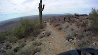
Videos of Tempe Mountain Bike
trail: Papago Conn
0:45 |
1038 |
Jun 26, 2020
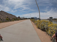
trail: Canal Path
8:33 |
100 |
Apr 2, 2019
trail: Papago Acc
0:09 |
413 |
Jan 11, 2019
trail: Loma
7:12 |
350 |
Oct 25, 2015

3:46 |
2907 |
Aug 23, 2021

trail: Hole In The Rock
0:00 |
1170 |
Mar 16, 2018 , Tempe

trail: Elliot Ramada Loop
0:28 |
1072 |
Mar 15, 2018 , Tempe

trail: Vigilante
0:51 |
1373 |
Mar 12, 2018 , Tempe
Recent Trail Reports
Activity Feed
| username | action | type | title | date |
|---|---|---|---|---|
| 0DCJ1d | ridden | trail | activity #95907601 | May 30, 2026 @ 8:24pm May 30, 2026 |
| Balagg9cKR | wishlist | trail | activity #95752413 | May 28, 2026 @ 7:43pm May 28, 2026 |
| Balagg9cKR | ridden | trail | activity #95223600 | May 21, 2026 @ 10:27pm May 21, 2026 |
| dlr1967 | add | report | activity #94377936 and 1 more | May 9, 2026 @ 2:17pm May 9, 2026 |
| dlr1967 | add | report | activity #94377924 and 13 more | May 9, 2026 @ 2:17pm May 9, 2026 |
Recent Comments
| username | type | title | comment | date |
|---|---|---|---|---|
| trail | I filled in the big rut that runs along this trail | Nov 10, 2025 @ 10:15am Nov 10, 2025 | ||
| trail | Spent a few days cleaning up the length of... | Nov 10, 2025 @ 10:12am Nov 10, 2025 | ||
| trail | I filled in the ruts on the downhill leading... | Nov 7, 2025 @ 7:44am Nov 7, 2025 | ||
| trail | More of a blue with a techy narrow climb at... | Nov 6, 2025 @ 8:23am Nov 6, 2025 | ||
| trail | I'm planning to fill in the big rut on the... | Nov 6, 2025 @ 8:21am Nov 6, 2025 |
Local Badges
-

10 Green Trails444 awarded -

Epic Ride Climb 2k16 awarded -

Climbing 10k Badge114 awarded -

Climbing 100k Badge3 awarded -

Epic Ride Descent 2k16 awarded -

Descent 10k Badge115 awarded
Bike & Skill Parks
| name | type | city | rating |
|---|---|---|---|
| Papago Dirt Jumps | skill park | Tempe |
Activity Type Stats
| activitytype | trails | distance | descent | descent distance | total vertical | rating | global rank | state rank | photos | reports | routes | ridelogs |
|---|---|---|---|---|---|---|---|---|---|---|---|---|
| Mountain Bike | 114 | 58 miles | 2,267 ft | 22 miles | 315 ft | #892 | #351 | 88 | 463 | 12 | 68,045 | |
| E-Bike | 26 | 19 miles | 82 ft | 7 miles | 148 ft | #4,491 | #1,447 | 444 | 1 | 1,283 | ||
| Gravel Bike | 7 | #496 | #1,061 | 2 | 6 | 329 | ||||||
| Horse | 1 | 7 miles | 26 ft | 5 miles | 26 ft | 68 | 3 | |||||
| Hike | 112 | 57 miles | 2,067 ft | 21 miles | 315 ft | #1,925 | #830 | 15 | 460 | 6 | 2,865 | |
| Trail Running | 112 | 57 miles | 2,067 ft | 21 miles | 315 ft | #2,330 | #713 | 460 | 4,233 |
Frequently Asked Questions About Tempe
▼
What are the best places to ride in Tempe?
Tempe has 1 areas to explore for mountain biking. The top rated areas are:
▼
What are the highest rated mountain biking trails in Tempe?
The highest rated mountain biking trails in Tempe are:
- Vigilante (4.3/5)
- 'A' Mountain Trail (4.2/5)
- Loma 'Descent' (4.2/5)
- High Butte (4.1/5)
- Spicy Curry (4.1/5)
▼
What is the best time of the year to ride in Tempe?
Based on ride log data, the most popular months to ride in Tempe are:
- October (341 activities)
- November (324 activities)
- May (290 activities)
▼
Where can I park to ride in Tempe?
There are 12 parking locations listed in Tempe. The most popular parking spots are: View all parking and trailhead locations on the map to plan your visit.
Activities
Trails
- By canadaka
 Trailforks & contributors
 - Admins: AZT, chainslapAZ, schillingsworth, jeffgicklhorn, jpmcghee, msmcfate, cemoorelife, Schwinnshralper26
- #4996 - 9,087 views
- tempe activity log | embed map of Tempe mountain bike trails | tempe mountain biking points of interest
Downloading of trail gps tracks in kml & gpx formats is enabled for Tempe.
You must login to download files.