close
-
Layers w
- Weather Layers
- Pro
- Pro
- Pro
- Pro
- Pro
- Pro
- More Layers
- Pro
- Pro
- Pro
- Pro
-
Upgrade to

3D
Trail Conditions
- Unknown
- Snow Groomed
- Snow Packed
- Snow Covered
- Snow Cover Partial
- Freeze/thaw Cycle
- Icy
- Prevalent Mud
- Wet
- Variable
- Ideal
- Dry
- Very Dry
Trail Flow (Ridden Direction)
Trailforks scans users activity logs to determine the most popular direction each trail is ridden. A good flowing trail network will have most trails flowing in a single direction according to their intension.
The colour categories are based on what percentage of users are riding a trail in its intended direction.
The colour categories are based on what percentage of users are riding a trail in its intended direction.
- > 96%
- > 90%
- > 80%
- > 70%
- > 50%
- < 50%
- bi-directional trail
- no data
Trail Last Ridden
Trailforks scans activity logs to determine the last time a trail was ridden.
- < 2 days
- < 1 week
- < 2 weeks
- < 1 month
- < 6 months
- > 6 months
Trail Ridden Direction
The intended direction a trail should be ridden.
- Downhill Only
- Downhill Primary
- Both Directions
- Uphill Primary
- Uphill Only
- One Direction
Contribute Details
Colors indicate trail is missing specified detail.
- Description
- Photos
- Description & Photos
- Videos
Trail Popularity ?
Trailforks scans activity logs to determine which trails are ridden the most in the last 9 months.
Trails are compared with nearby trails in the same city region with a possible 25 colour shades.
Think of this as a heatmap, more activities = more kinetic energy = warmer colors.
- most popular
- popular
- less popular
- not popular
ATV/ORV/OHV Filter
Max Vehicle Width
inches
US Cell Coverage
Legend

Radar Time
Activity Recordings
Trailforks uses anonymized public activity data.
?
Activity Recordings
Trailforks uses anonymized public activity data.
?
Personal Heatmap
▶
Activity Types
all
/
none
▶
Options
2
Date range
month
–
Winter Trails
Warning
A routing network for winter maps does not exist. Selecting trails using the winter trails layer has been disabled.
Missing Trails
Most Popular
Least Popular
Trails are colored based on popularity. The more popular a trail is, the more red. Less popular trails trend towards green.
Jump Magnitude Heatmap
Heatmap of where users jump on trails. Zoom in to see individual jumps, click circles to view jump details.
BC Backroad Status
![map legend]()
Service Road Atlas is a free to use, community-driven service for viewing and creating reports on the numerous back-country service roads around B.C. and Alberta.

Slope Aspect
Direction the slope faces
Trails Deemphasized
Trails are shown in grey.
Only show trails with no bike usage.
Suggested Layers
Based on selected activity type
Save the current map location and zoom level as your default home location whenever this page is loaded.
Save
No description for Uscio has been added yet!
Login or register to submit one.
This region uses the Uk/Euro style trail grading system.
Activities Click to view
- Mountain Bike
15 trails
- E-Bike
12 trails
- Adaptive Bike
0 trails
- Hike
11 trails
- Trail Running
7 trails
Region Details
- 5
- 8
Region Status
Caution as of Jun 23, 2026Stats
- Avg Trail Rating
- Trails (view details)
- 14
- Trails Mountain Bike
- 15
- Trails E-Bike
- 12
- Trails Hike
- 11
- Trails Trail Running
- 7
- Total Distance
- 4 miles
- Total Descent Distance
- 2 miles
- Total Descent
- 1,396 ft
- Total Vertical
- 545 ft
- Highest Trailhead
- 1,910 ft
- Reports
- 84
- Photos
- 20
- Completed Counter
- 204
Popular Uscio Mountain Biking Trails
• 100 ★ 5.0 • 1 mile • 215 ft • 29 •
Popular blue difficulty singletrack. This mountain bike primary trail can be used downhill primary. On average it takes 18 minutes to complete this trail.
• 80 ★ 0.0 • 4,508 ft • 167 ft • 27 •
Facile sentiero che percorre la cresta alle spalle di Uscio
• 40 ★ 3.0 • 3,091 ft • 119 ft • 20 •
Moderately popular blue difficulty singletrack. This mountain bike primary trail can be used both directions. On average it takes 8 minutes to complete this trail.
• 45 ★ 3.0 • 2,969 ft • 117 ft • 18 •
Moderately popular blue difficulty singletrack. This mountain bike primary trail can be used both directions. On average it takes 13 minutes to complete this trail.
• 95 ★ 0.0 • 3,606 ft • 116 ft • 9 •
Short link for reaching "chiugulla" start. Some fun natural berns beofre entring the woods.
• 50 ★ 0.0 • 1,739 ft • 0 ft • 7 •
Easy trail leading to "chiapparino" restaurant. Some skinny (almost flat) sections.
• 15 ★ 3.0 • 1,184 ft • 0 ft • 6 •
Less popular blue difficulty singletrack. This mountain bike primary trail can be used both directions. On average it takes 4 minutes to complete this trail.
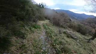
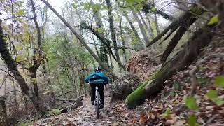
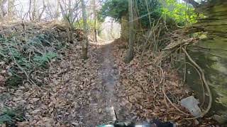
Photos of Uscio Mountain Bike
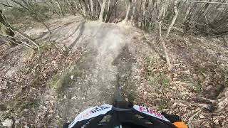
Videos of Uscio Mountain Bike
trail: Croce Rossa
2:18 |
44 |
Jan 19, 2025 , Uscio
trail: Bretella NS Bosco
3:23 |
87 |
Nov 29, 2024 , Uscio
trail: Chigulla
5:23 |
146 |
Mar 27, 2024 , Uscio
trail: Polveriera
5:19 |
210 |
Jan 27, 2023 , Uscio
Recent Trail Reports
| status | trail | date | condition | info | user |
|---|---|---|---|---|---|
| Nostra Signora del Bosco | Jun 23, 2026 @ 9:04am (Europe/Rome) Jun 23, 2026 | Ideal | kiazmtb | ||
| Collegamento - link Boschetto | May 24, 2026 @ 8:08am (Pacific/Midway) May 24, 2026 | Ideal | serginov | ||
| Bretella NS Bosco | May 19, 2026 @ 8:25pm (Europe/Rome) May 19, 2026 | Variable | max90savona | ||
| Chiapparino | Mar 21, 2026 @ 5:30pm (Europe/Rome) Mar 21, 2026 | Ideal | Corrado64 | ||
| Casa del Cinese | Mar 21, 2026 @ 5:26pm (Europe/Rome) Mar 21, 2026 | Ideal | Corrado64 | ||
| Polveriera | Mar 21, 2026 @ 5:24pm (Europe/Rome) Mar 21, 2026 | Ideal | Corrado64 | ||
| Testana da Calcinara | Jan 11, 2026 @ 7:57am (Europe/Rome) Jan 10, 2026 | Variable | serginov | ||
| Chigulla | Sep 30, 2025 @ 2:00pm (Europe/Rome) Sep 30, 2025 | Variable | kiazmtb | ||
| Croce Rossa | Sep 11, 2025 @ 2:05pm Sep 11, 2025 | Variable | kiazmtb | ||
| Colonia Arnaldi | Jun 11, 2025 @ 2:33pm Jun 11, 2025 | Ideal | kiazmtb |
Activity Feed
| username | action | type | title | date |
|---|---|---|---|---|
| kiazmtb | add | report | activity #97628713 | Jun 23, 2026 @ 8:22am Jun 23, 2026 |
| serginov | add | report | activity #95509150 | May 25, 2026 @ 11:43am May 25, 2026 |
| max90savona | add | report | activity #95055381 | May 19, 2026 @ 11:25am May 19, 2026 |
| LucaT71 | vote | trail | activity #93436617 | Apr 26, 2026 @ 6:33am Apr 26, 2026 |
| LucaT71 | ridden | trail | activity #93436043 and 1 more | Apr 26, 2026 @ 6:25am Apr 26, 2026 |
Recent Comments
| username | type | title | comment | date |
|---|---|---|---|---|
| trail | Chiuso da vegetazione non più praticabile | Nov 12, 2024 @ 9:09am Nov 12, 2024 | ||
| trail | Meglio solo discesa | Oct 6, 2020 @ 4:49am Oct 6, 2020 |
Local Badges
-

Epic Mountain Bike Climb 2k0 awarded -

Climbing 10k Badge0 awarded -

Mountain Biking 100k Badge0 awarded -

Epic Ride Descent 2k0 awarded -

Descent 10k Badge0 awarded -

Descent 100k Badge0 awarded
Activity Type Stats
| activitytype | trails | distance | descent | descent distance | total vertical | rating | global rank | state rank | photos | reports | routes | activity logs |
|---|---|---|---|---|---|---|---|---|---|---|---|---|
| Mountain Bike | 15 | 4 miles | 1,394 ft | 2 miles | 545 ft | #10,080 | #999 | 6 | 84 | 670 | ||
| E-Bike | 12 | 3 miles | 988 ft | 2 miles | 545 ft | #3,119 | #298 | 14 | 83 | 57 | ||
| Hike | 11 | 3 miles | 1,211 ft | 2 miles | 545 ft | #12,631 | #944 | 81 | 12 | |||
| Trail Running | 7 | 3 miles | 784 ft | 2 miles | 449 ft | #12,765 | #993 | 78 | 2 |
Frequently Asked Questions About Uscio
▼
What are the highest rated mountain biking trails in Uscio?
The highest rated mountain biking trails in Uscio are:
- Polveriera (4.1/5)
- Colonia Arnaldi (3.8/5)
- La Rapallina (3.8/5)
- Castello vecchio (3.8/5)
- Collegamento - link Boschetto (0/5)
▼
What is the best time of the year to ride in Uscio?
Based on activity log data, the most popular months to ride in Uscio are:
- December (3 activities)
- January (1 activities)
- October (1 activities)
▼
Where can I park to ride in Uscio?
Check the Uscio trail map for trailhead and parking information. Community members regularly update access and parking details for trails in the area.
▼
What is the longest trail in Uscio?
The longest trail in Uscio is Polveriera at 1.2 miles. View all trails sorted by distance.
Activities
Trails
Points of Interest
- By 19andrea87
 & contributors
 - Admins: denitopia, linomak
- #40262 - 1,619 views
- uscio activity log | embed map of Uscio mountain bike trails |
Downloading of trail gps tracks in kml & gpx formats is enabled for Uscio.
You must login to download files.