close
-
Layers w
- Weather Layers
- Pro
- Pro
- Pro
- Pro
- Pro
- Pro
- More Layers
- Pro
- Pro
- Pro
- Pro
-
Upgrade to

3D
Trail Conditions
- Unknown
- Snow Groomed
- Snow Packed
- Snow Covered
- Snow Cover Partial
- Freeze/thaw Cycle
- Icy
- Prevalent Mud
- Wet
- Variable
- Ideal
- Dry
- Very Dry
Trail Flow (Ridden Direction)
Trailforks scans users ridelogs to determine the most popular direction each trail is ridden. A good flowing trail network will have most trails flowing in a single direction according to their intension.
The colour categories are based on what percentage of riders are riding a trail in its intended direction.
The colour categories are based on what percentage of riders are riding a trail in its intended direction.
- > 96%
- > 90%
- > 80%
- > 70%
- > 50%
- < 50%
- bi-directional trail
- no data
Trail Last Ridden
Trailforks scans ridelogs to determine the last time a trail was ridden.
- < 2 days
- < 1 week
- < 2 weeks
- < 1 month
- < 6 months
- > 6 months
Trail Ridden Direction
The intended direction a trail should be ridden.
- Downhill Only
- Downhill Primary
- Both Directions
- Uphill Primary
- Uphill Only
- One Direction
Contribute Details
Colors indicate trail is missing specified detail.
- Description
- Photos
- Description & Photos
- Videos
Trail Popularity ?
Trailforks scans ridelogs to determine which trails are ridden the most in the last 9 months.
Trails are compared with nearby trails in the same city region with a possible 25 colour shades.
Think of this as a heatmap, more rides = more kinetic energy = warmer colors.
- most popular
- popular
- less popular
- not popular
ATV/ORV/OHV Filter
Max Vehicle Width
inches
US Cell Coverage
Legend

Radar Time
Activity Recordings
Trailforks uses anonymized public activity data.
?
Activity Recordings
Trailforks uses anonymized public activity data.
?
Personal Heatmap
▶
Activity Types
all
/
none
▶
Options
2
Date range
month
–
Winter Trails
Warning
A routing network for winter maps does not exist. Selecting trails using the winter trails layer has been disabled.
Missing Trails
Most Popular
Least Popular
Trails are colored based on popularity. The more popular a trail is, the more red. Less popular trails trend towards green.
Jump Magnitude Heatmap
Heatmap of where riders jump on trails. Zoom in to see individual jumps, click circles to view jump details.
BC Backroad Status
![map legend]()
Service Road Atlas is a free to use, community-driven service for viewing and creating reports on the numerous back-country service roads around B.C. and Alberta.

Slope Aspect
Direction the slope faces
Trails Deemphasized
Trails are shown in grey.
Only show trails with no bike usage.
Suggested Layers
Based on selected activity type
Save the current map location and zoom level as your default home location whenever this page is loaded.
Save
No description for Wayne has been added yet!
Login or register to submit one.
Activities Click to view
- Mountain Bike
81 trails
- Gravel Bike
0 trails
- Adaptive Bike
0 trails
- Winter Fat Bike
0 trails
- Hike
81 trails
- Trail Running
81 trails
Region Details
- 22
- 2
- 51
- 6
Region Status
Open as of May 28, 2026Stats
- Avg Trail Rating
- Trails (view details)
- 81
- Trails Mountain Bike
- 81
- Trails Hike
- 81
- Trails Trail Running
- 81
- Total Distance
- 42 miles
- Total Descent
- 7,388 ft
- Total Vertical
- 494 ft
- Highest Trailhead
- 878 ft
- Reports
- 1,828
- Photos
- 119
- Ridden Counter
- 9,912
Sub Regions
-
High Mountain
- 2
- 51
- 6
Popular Wayne Mountain Biking Trails
• 95 ★ 3.9 • 3,071 ft • 14 ft • 257 •
Popular blue difficulty singletrack. This mountain bike primary trail can be used both directions and has a moderate overall physical rating with a 14 ft blue climb. It features rock face and rock garden. On average it takes 7 minutes to complete this trail.
• 80 ★ 0.0 • 1,765 ft • 36 ft • 243 •
Popular blue difficulty singletrack. This mountain bike primary trail can be used both directions. It features rock garden. On average it takes 5 minutes to complete this trail.
• 75 ★ 5.0 • 4,564 ft • 86 ft • 213 •
Popular blue difficulty singletrack. This mountain bike primary trail can be used both directions with a 86 ft blue climb. It features rock garden. On average it takes 8 minutes to complete this trail.
• 85 ★ 3.0 • 2,549 ft • 21 ft • 211 •
Popular blue difficulty singletrack. This mountain bike primary trail can be used both directions and has a easy overall physical rating with a 21 ft green climb. On average it takes 3 minutes to complete this trail.
• 90 ★ 4.0 • 1,693 ft • 3 ft • 204 •
Popular black diamond difficulty mixed. This mountain bike primary trail can be used downhill primary and has a hard overall physical rating with a 3 ft black diamond climb. It features rock garden. Trail visibility is always easy to follow. On average it takes 3 minutes to complete this trail.
• 95 ★ 4.0 • 1,339 ft • 0 ft • 204 •
Popular blue difficulty singletrack. This mountain bike primary trail can be used both directions and has a moderate overall physical rating with a 0 ft blue climb. On average it takes 2 minutes to complete this trail.
• 70 ★ 4.5 • 2,300 ft • 61 ft • 201 •
Popular blue difficulty singletrack. This mountain bike primary trail can be used both directions. It features rock garden. On average it takes 5 minutes to complete this trail.
Wayne Mountain Bike Routes
★ 5.0 • 15 miles • 1,760 ft • 15 • Loop •
This route is different than the High Mountain Tour and High Mountain Tour ll. There is lots of climbing...
★ 3.5 • 16 miles • 1,996 ft • 49 • Loop •
A somewhat grand tour of High Mountain Park Preserve. *** (FYI - I fixed a bunch of waypoint errors...
★ 5.0 • 10 miles • 1,219 ft • 16 • Loop •
This is a great sampler of many of the most popular trails at High Mountain. There is a nice view of New...
★ 4.4 • 6 miles • 848 ft • 3 • Loop •
One of the most popular loops at High Mountain. The route is fun in both directions but Jack’s can be a...
6 miles • 623 ft • 7 • Loop •
High Mountain has a great deal of rocky terrain with narrow technical singletrack. Trails the route covers...
15 miles • 1,887 ft • 11 • Loop •
Took the original creators route or ride log and copied it as it had a number of waypoints that went in...
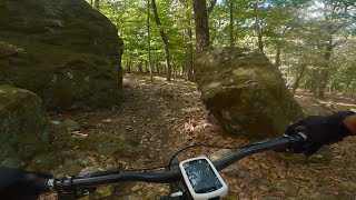
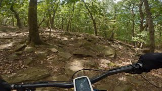
Photos of Wayne Mountain Bike
Videos of Wayne Mountain Bike

trail: Upper Ancients
7:52 |
250 |
May 6, 2023 , Wayne

trail: Upper Ancients
10:09 |
113 |
May 5, 2023 , Wayne
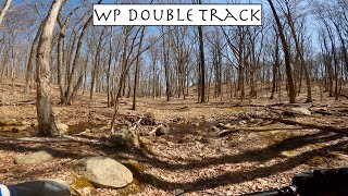
trail: WP Double Track
17:20 |
211 |
May 5, 2023 , Wayne

15:48 |
157 |
Apr 20, 2023
55:08 |
132 |
Apr 5, 2023
trail: Hawk
8:31 |
234 |
Aug 16, 2022 , Wayne
trail: Secret
4:12 |
205 |
Aug 16, 2022 , Wayne
trail: Indians Loop
6:15 |
197 |
Aug 14, 2022 , Wayne
Current Trail Warnings
| status | trail | date | condition | user | info |
|---|---|---|---|---|---|
| Cracked Foundation | May 28, 2026 @ 9:57am (America/New_York) May 28, 2026 | Ideal | RobJSinger | best ridden southwest - lots of trail is... |
Recent Trail Reports
| status | trail | date | condition | info | user |
|---|---|---|---|---|---|
| Black Bear | May 28, 2026 @ 9:57am (America/New_York) May 28, 2026 | Ideal | RobJSinger | ||
| Junkyard Loop Proposed Closure 11/2021 | May 28, 2026 @ 9:57am (America/New_York) May 28, 2026 | Ideal | RobJSinger | ||
| Sanderling Rd [Link] | May 28, 2026 @ 9:57am (America/New_York) May 28, 2026 | Ideal | RobJSinger | ||
| Ancients Close 2021 | May 28, 2026 @ 9:57am (America/New_York) May 28, 2026 | Ideal | RobJSinger | ||
| Ancients | May 28, 2026 @ 9:57am (America/New_York) May 28, 2026 | Ideal | RobJSinger | ||
| Ancients Close 2021 | May 28, 2026 @ 9:57am (America/New_York) May 28, 2026 | Ideal | RobJSinger | ||
| Ancients 2021 | May 28, 2026 @ 9:57am (America/New_York) May 28, 2026 | Ideal | RobJSinger | ||
| Orange Trail (Beech Mountain-Clove Trail) | May 28, 2026 @ 9:57am (America/New_York) May 28, 2026 | Ideal | RobJSinger | ||
| Yellow Trail (Summit Trail) - IV (Fall Line DH) | May 28, 2026 @ 9:57am (America/New_York) May 28, 2026 | Ideal | RobJSinger | ||
| Indians Loop | May 28, 2026 @ 9:57am (America/New_York) May 28, 2026 | Ideal | RobJSinger |
Activity Feed
| username | action | type | title | date |
|---|---|---|---|---|
| wescalmoore | wishlist | region | activity #97536588 | Jun 21, 2026 @ 6:29pm 2 hours |
| RobJSinger | add | report | activity #95722978 and 13 more | May 28, 2026 @ 11:43am May 28, 2026 |
| cirruseric | wishlist | route | activity #95631867 | May 27, 2026 @ 7:07am May 27, 2026 |
| cirruseric | wishlist | trail | activity #95631595 | May 27, 2026 @ 7:02am May 27, 2026 |
| b-list | add | photo | activity #95536147 and 1 more | May 25, 2026 @ 5:53pm May 25, 2026 |
Recent Comments
| username | type | title | comment | date |
|---|---|---|---|---|
| trail | h | Mar 11, 2026 @ 5:59am Mar 11, 2026 | ||
| trail | I spent more time trying to find the trail... | Oct 31, 2024 @ 10:34am Oct 31, 2024 | ||
| trail | This trail is fenced off. You cannot pass through | Feb 5, 2024 @ 8:14am Feb 5, 2024 | ||
| report | Hj | Jul 6, 2023 @ 12:07pm Jul 6, 2023 | ||
| report | Really rocky trail. Mango-sized boulders... | Jun 19, 2023 @ 12:17pm Jun 19, 2023 |
Local Badges
-

10 Blue Trails163 awarded -

Epic Ride Climb 2k0 awarded -

Climbing 10k Badge22 awarded -

Climbing 100k Badge0 awarded -

Epic Ride Descent 2k0 awarded -

Descent 10k Badge22 awarded
Activity Type Stats
| activitytype | trails | distance | descent | descent distance | total vertical | rating | global rank | state rank | photos | reports | routes | ridelogs |
|---|---|---|---|---|---|---|---|---|---|---|---|---|
| Mountain Bike | 81 | 42 miles | 7,388 ft | 20 miles | 495 ft | #1,630 | #613 | 118 | 1,826 | 12 | 6,957 | |
| Hike | 81 | 42 miles | 7,388 ft | 20 miles | 495 ft | #4,576 | #1,617 | 1,822 | 1 | 459 | ||
| Trail Running | 81 | 42 miles | 7,388 ft | 20 miles | 495 ft | #4,055 | #1,230 | 1,822 | 1 | 223 |
Frequently Asked Questions About Wayne
▼
What are the best places to ride in Wayne?
Wayne has 1 areas to explore for mountain biking. The top rated areas are:
▼
What are the highest rated mountain biking trails in Wayne?
The highest rated mountain biking trails in Wayne are:
- Ancients (4.4/5)
- Camel's Hump (4.3/5)
- Indians Loop (4.3/5)
- Jack's (4.2/5)
- Dyn-O-Mite! (4.2/5)
▼
What is the best time of the year to ride in Wayne?
Based on ride log data, the most popular months to ride in Wayne are:
- July (173 activities)
- May (141 activities)
- August (138 activities)
▼
Where can I park to ride in Wayne?
There are 4 parking locations listed in Wayne. The most popular parking spots are:
- Parking (Park in the straight road before or after the circle)
- Parking
- Parking - Franklin Lakes Nature Preserve
- Parking
Trails
Points of Interest
- By canadaka
 Trailforks & contributors
 - Admins: NYNJTC, josowski, Tkeyworth
- #15041 - 4,196 views
- wayne activity log | embed map of Wayne mountain bike trails | wayne mountain biking points of interest
Downloading of trail gps tracks in kml & gpx formats is enabled for Wayne.
You must login to download files.