close
-
Layers w
- Weather Layers
- Pro
- Pro
- Pro
- Pro
- Pro
- Pro
- More Layers
- Pro
- Pro
- Pro
- Pro
-
Upgrade to

3D
Trail Conditions
- Unknown
- Snow Groomed
- Snow Packed
- Snow Covered
- Snow Cover Partial
- Freeze/thaw Cycle
- Icy
- Prevalent Mud
- Wet
- Variable
- Ideal
- Dry
- Very Dry
Trail Flow (Ridden Direction)
Trailforks scans users ridelogs to determine the most popular direction each trail is ridden. A good flowing trail network will have most trails flowing in a single direction according to their intension.
The colour categories are based on what percentage of riders are riding a trail in its intended direction.
The colour categories are based on what percentage of riders are riding a trail in its intended direction.
- > 96%
- > 90%
- > 80%
- > 70%
- > 50%
- < 50%
- bi-directional trail
- no data
Trail Last Ridden
Trailforks scans ridelogs to determine the last time a trail was ridden.
- < 2 days
- < 1 week
- < 2 weeks
- < 1 month
- < 6 months
- > 6 months
Trail Ridden Direction
The intended direction a trail should be ridden.
- Downhill Only
- Downhill Primary
- Both Directions
- Uphill Primary
- Uphill Only
- One Direction
Contribute Details
Colors indicate trail is missing specified detail.
- Description
- Photos
- Description & Photos
- Videos
Trail Popularity ?
Trailforks scans ridelogs to determine which trails are ridden the most in the last 9 months.
Trails are compared with nearby trails in the same city region with a possible 25 colour shades.
Think of this as a heatmap, more rides = more kinetic energy = warmer colors.
- most popular
- popular
- less popular
- not popular
ATV/ORV/OHV Filter
Max Vehicle Width
inches
US Cell Coverage
Legend

Radar Time
Activity Recordings
Trailforks uses anonymized public activity data.
?
Activity Recordings
Trailforks uses anonymized public activity data.
?
Personal Heatmap
▶
Activity Types
all
/
none
▶
Options
2
Date range
month
–
Winter Trails
Warning
A routing network for winter maps does not exist. Selecting trails using the winter trails layer has been disabled.
Missing Trails
Most Popular
Least Popular
Trails are colored based on popularity. The more popular a trail is, the more red. Less popular trails trend towards green.
Jump Magnitude Heatmap
Heatmap of where riders jump on trails. Zoom in to see individual jumps, click circles to view jump details.
BC Backroad Status
![map legend]()
Service Road Atlas is a free to use, community-driven service for viewing and creating reports on the numerous back-country service roads around B.C. and Alberta.

Slope Aspect
Direction the slope faces
Trails Deemphasized
Trails are shown in grey.
Only show trails with no bike usage.
Suggested Layers
Based on selected activity type
Save the current map location and zoom level as your default home location whenever this page is loaded.
Save
No description for Yellowknife has been added yet!
Login or register to submit one.
Region Supporters & Maintainers
Activities Click to view
- Mountain Bike
166 trails
- E-Bike
35 trails
- Gravel Bike
0 trails
- Adaptive Bike
0 trails
- Winter Fat Bike
0 trails
- Hike
144 trails
- Trail Running
127 trails
- Snowshoe
24 trails
- Backcountry Ski
10 trails
- Nordic Ski
13 trails
Region Details
- 6
- 5
- 46
- 71
- 35
- 3
Region Status
Open as of 1 dayStats
- Avg Trail Rating
- Trails (view details)
- 177
- Trails Mountain Bike
- 166
- Trails E-Bike
- 35
- Trails Hike
- 144
- Trails Trail Running
- 127
- Trails Snowmobile
- 2
- Trails Snowshoe
- 24
- Trails Backcountry Ski
- 10
- Trails Nordic Ski
- 13
- Total Distance
- 114 miles
- Total Descent
- 6,488 ft
- Total Vertical
- 292 ft
- Highest Trailhead
- 804 ft
- Reports
- 304
- Photos
- 37
- Ridden Counter
- 1,509
Sub Regions
-
Bristol Trail Network
- 1
- 1
- 8
- 3
-
Frame Lake Trails
-
Ingraham Trail
- 9
- 10
- 3
-
Ski Club
- 2
- 9
- 12
- 13
- 1
-
Ski Club
- 5
- 3
- 2
-
The Holdout
- 1
-
Tin Can Hill
- 8
- 2
-
Tsi Cho P'Noo Cho
- 4
- 2
-
Twin Pine Hill
Popular Yellowknife Mountain Biking Trails
• 100 ★ 4.0 • 1,247 ft • 24 ft • 25 •
Short bit of trail that diverges from the main trail. Winter conditions vary based on snowfall and level of foot traffic. Easier to ride in the Winter than the summer.
• 65 ★ 4.8 • 1 mile • 135 ft • 25 •
Singletrack circuit out and back to YK river outlook.
• 80 ★ 0.0 • 2,618 ft • 61 ft • 21 •
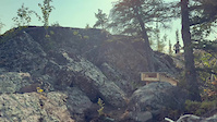
Popular blue difficulty singletrack. This mountain bike primary trail can be used one direction. It features rock face. On average it takes 8 minutes to complete this trail.
• 60 ★ 4.0 • 4,957 ft • 93 ft • 20 •
To be avoided early spring melt due to unhygienic dog scat conditions. City designated 'off-leash' area highly frequented by dog owners who are mostly incapable of picking up after their pets.
• 70 ★ 5.0 • 1,259 ft • 10 ft • 20 •
Popular blue difficulty singletrack. This mountain bike primary trail can be used both directions. On average it takes 2 minutes to complete this trail.
• 50 ★ 3.0 • 2 miles • 186 ft • 19 •
Hiking Trail. Lots of short bursty climbs and little techie sections. There are a couple sections where you may need to carry your bike, staircases can be ridden down when you ride counter-clockwise. There is one large rocky hill which...
• 70 ★ 0.0 • 2,308 ft • 52 ft • 18 •
Popular green difficulty singletrack. This mountain bike primary trail can be used both directions. On average it takes 3 minutes to complete this trail.
Yellowknife Mountain Bike Routes
★ 4.4 • 3 miles • 165 ft • 3 • Out & Back •
Ridge route to camping area at the north end of Bighill Lake. Avoids all bogs, water, and tough scrambles....
Photos of Yellowknife Mountain Bike
Videos of Yellowknife Mountain Bike
trail: Camp Crasher
0:06 |
36 |
Jun 27, 2025
trail: Snakes
0:11 |
91 |
Aug 25, 2019
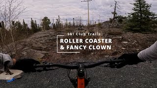
trail: Mini Roller Coaster
0:47 |
60 |
Jul 12, 2025 , Yellowknife

trail: Fancy Clown
0:47 |
58 |
Jul 12, 2025 , Yellowknife
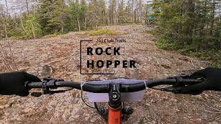
trail: Rock Hopper
0:45 |
45 |
Jul 12, 2025 , Yellowknife
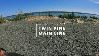
trail: Twin Pine Main Line
0:33 |
72 |
Jul 12, 2025 , Yellowknife
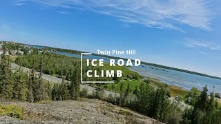
trail: Ice Road Climb
0:38 |
61 |
Jul 12, 2025 , Yellowknife
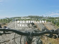
trail: Bug Repellent
66 |
Jul 12, 2025 , Yellowknife
Recent Trail Reports
Activity Feed
| username | action | type | title | date |
|---|---|---|---|---|
| trebor | add | report | activity #98366024 and 3 more | Jul 3, 2026 @ 2:20pm Jul 3, 2026 |
| Lupton | add | report | activity #95911165 | May 30, 2026 @ 11:05pm May 30, 2026 |
| Lupton | add | report | activity #95002963 | May 18, 2026 @ 3:09pm May 18, 2026 |
| GIMBGIMB | update | trail | activity #93240527 | Apr 23, 2026 @ 2:47pm Apr 23, 2026 |
| MikeZTvr7D | wishlist | trail | activity #89983364 | Mar 4, 2026 @ 5:08pm Mar 4, 2026 |
Recent Comments
| username | type | title | comment | date |
|---|---|---|---|---|
| trail | Are E-Bikes permitted on this trail? | Jul 17, 2025 @ 7:28am Jul 17, 2025 | ||
| trail | Must ride on it! | Feb 2, 2024 @ 7:44am Feb 2, 2024 | ||
| trail | Fat Track | Jan 31, 2024 @ 2:10pm Jan 31, 2024 | ||
| trail | Weird trail Haha | Jan 31, 2024 @ 2:04pm Jan 31, 2024 | ||
| trail | wow | Jan 30, 2024 @ 1:12pm Jan 30, 2024 |
Local Badges
-

Completionist0 awarded -

Epic Ride 50k45 awarded -

Top 10 Trails0 awarded -

10 Blue Trails12 awarded -

Big Ride 30k127 awarded -
Completionist0 awarded
Bike & Skill Parks
| name | type | city | rating |
|---|---|---|---|
| BMX / Skate Park | skill park | Yellowknife | |
| Mike Haener Memorial Bike Park | skill park | Yellowknife |
Activity Type Stats
| activitytype | trails | distance | descent | descent distance | total vertical | rating | global rank | state rank | photos | reports | routes | ridelogs |
|---|---|---|---|---|---|---|---|---|---|---|---|---|
| Mountain Bike | 166 | 78 miles | 4,954 ft | 22 miles | 272 ft | #1,371 | #1 | 36 | 298 | 17 | 3,833 | |
| E-Bike | 35 | 3 miles | 328 ft | 1 mile | 144 ft | #4,550 | #1 | 253 | 620 | |||
| Hike | 144 | 73 miles | 4,646 ft | 20 miles | 276 ft | #850 | #1 | 1 | 283 | 8 | 365 | |
| Trail Running | 127 | 59 miles | 3,560 ft | 15 miles | 187 ft | #2,582 | #1 | 274 | 938 | |||
| Snowmobile | 2 | 10 miles | 440 ft | 3 miles | 233 ft | 1 | ||||||
| Snowshoe | 24 | 17 miles | 938 ft | 5 miles | 266 ft | #670 | #1 | 14 | 2 | 46 | ||
| Backcountry Ski | 10 | 9 miles | 351 ft | 3 miles | 266 ft | #486 | #1 | 12 | 2 | 9 | ||
| Nordic Ski | 13 | 30 miles | 971 ft | 11 miles | 223 ft | #544 | #1 | 1 | 707 |
Frequently Asked Questions About Yellowknife
▼
What are the best places to ride in Yellowknife?
Yellowknife has 9 areas to explore for mountain biking. The top rated areas are:
▼
What are the highest rated mountain biking trails in Yellowknife?
The highest rated mountain biking trails in Yellowknife are:
- The Holdout (4.3/5)
- Midnight Slice (4.1/5)
- BBQ Fridays (4.1/5)
- Bush Pilot Connector (4.1/5)
- Pistol Shrimp (4.1/5)
▼
What is the best time of the year to ride in Yellowknife?
Based on ride log data, the most popular months to ride in Yellowknife are:
- December (25 activities)
- September (16 activities)
- July (9 activities)
▼
Where can I park to ride in Yellowknife?
There are 10 parking locations listed in Yellowknife. The most popular parking spots are: View all parking and trailhead locations on the map to plan your visit.
Activities
Trails
- By ykmtbc
 & contributors
 - Admins: YKmtbC, tdhont, Lupton, dinahmite, GIMBGIMB
- #8549 - 16,065 views
- yellowknife activity log | embed map of Yellowknife mountain bike trails | yellowknife mountain biking points of interest
Downloading of trail gps tracks in kml & gpx formats is enabled for Yellowknife.
You must login to download files.