6.2 miles
Distance
983 ft
Climb
-1,257 ft
Descent
1,525 ft
High Point
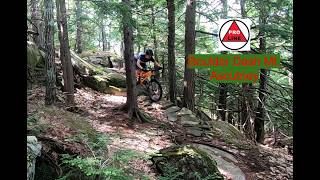
Start at the Town Forest trailhead and finish back at the AOC for a tour of some more challenging trails. This covers a lot of intermediate-advanced terrain connecting more technical, rocky trails including Falls from Grace, Boulder Dash, Cloud 9.9 and Quarry Chase. Non-rock lovers will have some options of go-around routes, so strong intermediates are welcome.
Detailed Description
A bit Boulder is a 6 mile popular intermediate route located near Brownsville Vermont. This mountain bike only route. This route includes 18 trails. This route climbs 983 ft with a max elevation of 1,525 ft then descends -1,257 ft.
Local Trail Association
Ascutney Trails Association (www.ascutneytrails.com)Please consider joining or donating to the local riding association to support trail development & maintenance.
donate to earn trail karma!
We hope you've been enjoying Trailforks!
Create a FREE account to view route comments and much more.
Trails in Route
1,604 ft | |||||
1,775 ft | |||||
614 ft | |||||
945 ft | |||||
712 ft | |||||
994 ft | |||||
1,352 ft | |||||
3,123 ft | |||||
272 ft | |||||
469 ft | |||||
240 ft | |||||
1,765 ft | |||||
1,975 ft | |||||
1,079 ft | |||||
240 ft | |||||
965 ft | |||||
2,408 ft |
Details
-
Riding area
-
Primary ActivityMountain Bike
-
Difficulty ratingBlue
-
eBike Allowed
-
Bike typeAM, XC
More Stats for A bit Boulder mountain bike route
-
Avg time1 hr 46 min
-
Altitude change-274 ft
-
Altitude min748 ft
-
Altitude start1,028 ft
-
Altitude end755 ft
-
Grade-0.8%
-
Grade max-52.6%
-
Grade min32.6%
-
Distance climb3 miles
-
Distance down3 miles
-
Distance flat3,524 ft
Directions
- Walk south on Cloud Climber.
- Continue for 100 meters.
- Walk east on Cloud Climber.
- Continue for 30 meters.
- Walk northeast on Cloud Climber.
- Continue for 100 meters.
- Walk south on Cloud Climber.
- Continue for 80 meters.
- Keep right to take Old Climber.
- Continue for 100 meters.
- Walk south on Old Climber.
- Continue for 200 meters.
- Walk east on Old Climber.
- Continue for 30 meters.
- Walk north on Old Climber.
- Continue for 40 meters.
- Walk northeast on Old Climber.
- Continue for 40 meters.
- Walk north on Old Climber.
- Continue for 100 meters.
- Walk north on Old Climber.
- Continue for 80 meters.
- Walk southwest on Burke Loop.
- Continue for 30 meters.
- Walk northeast on Burke Loop.
- Continue for 70 meters.
- Walk northeast on Burke Loop.
- Continue for 90 meters.
- Walk southeast on Burke Loop.
- Continue for 20 meters.
- Walk southwest on Burke Loop.
- Continue for 60 meters.
- Walk southwest on Burke Loop.
- Continue for 80 meters.
- Walk west on Burke Loop.
- Continue for 40 meters.
- Walk west on Burke Loop.
- Continue for 50 meters.
- Walk south on Burke Loop.
- Continue for 20 meters.
- Walk north on Burke Loop.
- Continue for 30 meters.
- Walk south on Burke Loop.
- Continue for 40 meters.
- Walk east on Burke Loop.
- Continue for 20 meters.
- Walk south on Burke Loop.
- Continue for 30 meters.
- Walk east on Burke Loop.
- Continue for 30 meters.
- Walk west on Pass the Buck.
- Continue for 30 meters.
- Walk northwest on Pass the Buck.
- Continue for 30 meters.
- Walk southwest on Pass the Buck.
- Continue for 40 meters.
- Walk northeast on Gracie's Loop.
- Continue for less than 10 meters.
- Walk southwest on Gracie's Loop.
- Continue for 40 meters.
- Walk south on Gracie's Loop.
- Continue for 50 meters.
- Walk northeast on Gracie's Loop.
- Continue for 70 meters.
- Walk northeast on Gracie's Loop.
- Continue for 80 meters.
- Walk east on Gracie's Loop.
- Continue for 20 meters.
- Walk south on Gracie's Loop.
- Continue for 40 meters.
- Walk southeast on Gracie's Loop.
- Continue for 40 meters.
- Walk southeast on Gracie's Loop.
- Continue for 20 meters.
- Walk southwest on Gracie's Loop.
- Continue for 20 meters.
- Walk west on Gracie's Loop.
- Continue for 20 meters.
- Walk northwest on Gracie's Loop.
- Continue for 30 meters.
- Walk southwest on Gracie's Loop.
- Continue for 20 meters.
- Walk southwest on Gracie's Loop.
- Continue for 30 meters.
- Walk east on Gracie's Loop.
- Continue for 30 meters.
- Walk south on Gracie's Loop.
- Continue for 20 meters.
- Walk southwest on Gracie's Loop.
- Continue for less than 10 meters.
- Walk southeast on Gracie's Loop.
- Continue for 20 meters.
- Walk southeast on Gracie's Loop.
- Continue for less than 10 meters.
- Walk south on Gracie's Loop.
- Continue for 10 meters.
- Walk west on Gracie's Loop.
- Continue for 20 meters.
- Walk southwest on Gracie's Loop.
- Continue for 60 meters.
- Walk west on Gracie's Loop.
- Continue for 10 meters.
- Walk southwest on Gracie's Loop.
- Continue for 20 meters.
- Walk southwest on Gracie's Loop.
- Continue for 20 meters.
- Walk west on Gracie's Loop.
- Continue for less than 10 meters.
- Walk southwest on Gracie's Loop.
- Continue for 10 meters.
- Walk west on Gracie's Loop.
- Continue for 10 meters.
- Walk southwest on Gracie's Loop.
- Continue for 40 meters.
- Walk southeast on Falls from Grace.
- Continue for 10 meters.
- Walk south on Falls from Grace.
- Continue for 10 meters.
- Walk southwest on Falls from Grace.
- Continue for 10 meters.
- Walk south on Falls from Grace.
- Continue for 10 meters.
- Walk south on Falls from Grace.
- Continue for 30 meters.
- Walk west on Falls from Grace.
- Continue for 10 meters.
- Walk south on Falls from Grace.
- Continue for 10 meters.
- Walk southwest on Falls from Grace.
- Continue for 40 meters.
- Walk southwest on Falls from Grace.
- Continue for 20 meters.
- Walk northwest on Falls from Grace.
- Continue for 10 meters.
- Walk north on Falls from Grace.
- Continue for 10 meters.
- Walk west on Falls from Grace.
- Continue for less than 10 meters.
- Walk south on Falls from Grace.
- Continue for 10 meters.
- Walk west on Falls from Grace.
- Continue for less than 10 meters.
- Walk northwest on Falls from Grace.
- Continue for 10 meters.
- Walk south on Falls from Grace.
- Continue for 20 meters.
- Walk southwest on Falls from Grace.
- Continue for less than 10 meters.
- Walk northwest on Falls from Grace.
- Continue for less than 10 meters.
- Walk north on Falls from Grace.
- Continue for 20 meters.
- Walk northwest on Falls from Grace.
- Continue for less than 10 meters.
- Walk southwest on Falls from Grace.
- Continue for less than 10 meters.
- Walk south on Falls from Grace.
- Continue for 20 meters.
- Walk west on Falls from Grace.
- Continue for 20 meters.
- Walk south on Falls from Grace.
- Continue for 20 meters.
- Walk south on Falls from Grace.
- Continue for 50 meters.
- Walk northwest on Falls from Grace.
- Continue for 40 meters.
- Walk north on Falls from Grace.
- Continue for 60 meters.
- Walk northwest on Falls from Grace.
- Continue for 40 meters.
- Walk northwest on Falls from Grace.
- Continue for 30 meters.
- Walk north on Falls from Grace.
- Continue for 40 meters.
- Walk northwest on Falls from Grace.
- Continue for 30 meters.
- Walk north on Last Mile.
- Continue for 100 meters.
- Walk northwest on Last Mile.
- Continue for 30 meters.
- Walk northeast on Last Mile.
- Continue for 60 meters.
- Walk north on Last Mile.
- Continue for 20 meters.
- Walk northeast on Last Mile.
- Continue for 30 meters.
- Walk east on Last Mile.
- Continue for 30 meters.
- Walk north on Last Mile.
- Continue for 60 meters.
- Walk northwest on Sluice.
- Continue for 20 meters.
- Walk west on Sluice.
- Continue for 30 meters.
- Walk north on Sluice.
- Continue for 30 meters.
- Walk west on Sluice.
- Continue for 30 meters.
- Walk north on Sluice.
- Continue for 30 meters.
- Walk north on Sluice.
- Continue for 10 meters.
- Walk north on Sluice.
- Continue for 30 meters.
- Walk northwest on Sluice.
- Continue for 10 meters.
- Walk west on Sluice.
- Continue for less than 10 meters.
- Walk southwest on Sluice.
- Continue for less than 10 meters.
- Walk west on Sluice.
- Continue for less than 10 meters.
- Walk northwest on Sluice.
- Continue for less than 10 meters.
- Walk north on Sluice.
- Continue for 20 meters.
- Walk north on Sluice.
- Continue for 20 meters.
- Walk north on Sluice.
- Continue for 60 meters.
- Walk northwest on Sluice.
- Continue for 20 meters.
- Walk north on Just Smile.
- Continue for less than 10 meters.
- Walk south on Sluice.
- Continue for less than 10 meters.
- Walk north on Just Smile.
- Continue for less than 10 meters.
- Walk south on Sluice.
- Continue for less than 10 meters.
- Turn right to stay on Sluice.
- Continue for 20 meters.
- Walk north on Sluice.
- Continue for 50 meters.
- Walk southwest on Utility Road.
- Continue for less than 10 meters.
- Walk southwest on Utility Road.
- Continue for 20 meters.
- Walk northwest on Lower Cort's Jester.
- Continue for 30 meters.
- Walk west on Lower Cort's Jester.
- Continue for 10 meters.
- Walk west on Lower Cort's Jester.
- Continue for 10 meters.
- Walk south on Lower Cort's Jester.
- Continue for 20 meters.
- Walk southeast on Lower Cort's Jester.
- Continue for less than 10 meters.
- Walk southwest on Lower Cort's Jester.
- Continue for 40 meters.
- Walk south on Lower Cort's Jester.
- Continue for 40 meters.
- Walk south on Picnic.
- Continue for less than 10 meters.
- Turn right to stay on Picnic.
- Continue for 10 meters.
- Walk north on Picnic.
- Continue for 20 meters.
- Walk north on Picnic.
- Continue for 30 meters.
- Walk north on Blue Dipper.
- Continue for 40 meters.
- Walk north on Blue Dipper.
- Continue for 30 meters.
- Walk north on Blue Dipper.
- Continue for 30 meters.
- Walk west on Blue Dipper.
- Continue for 50 meters.
- Walk west on Blue Dipper.
- Continue for less than 10 meters.
- Walk north on Hay Ride.
- Continue for 10 meters.
- Walk northwest on Hay Ride.
- Continue for 10 meters.
- Walk west on Hay Ride.
- Continue for 20 meters.
- Walk east on Hay Ride.
- Continue for less than 10 meters.
- Turn left to stay on Hay Ride.
- Continue for 30 meters.
- Walk north on Hay Ride.
- Continue for less than 10 meters.
- Turn left to stay on Hay Ride.
- Continue for 20 meters.
- Walk southwest on Hay Ride.
- Continue for 20 meters.
- Walk north on Picnic.
- Continue for 50 meters.
- Walk northeast on Picnic.
- Continue for 90 meters.
- Walk northeast on Picnic.
- Continue for 70 meters.
- Walk east on Picnic.
- Continue for 40 meters.
- Walk southeast on Home Again.
- Continue for 70 meters.
- Walk southeast on Home Again.
- Continue for 40 meters.
- Walk east on Home Again.
- Continue for 50 meters.
- Walk northeast on Home Again.
- Continue for 20 meters.
- Walk north on Home Again.
- Continue for 40 meters.
- Walk northeast on Home Again.
- Continue for 70 meters.
- Walk north on Home Again.
- Continue for 50 meters.
- Walk northwest on Home Again.
- Continue for 30 meters.
- Walk north on Home Again.
- Continue for 40 meters.
- Walk north on Home Again.
- Continue for 40 meters.
- Walk northeast on Home Again.
- Continue for 50 meters.
- Walk northeast on Home Again.
- Continue for 70 meters.
- Walk northeast on Home Again.
- Continue for 30 meters.
- Walk east on Home Again.
- Continue for 50 meters.
- Walk east on Home Again.
- Continue for 50 meters.
- Walk east on Home Again.
- Continue for 100 meters.
close
3D
Trail Conditions
- Unknown
- Snow Groomed
- Snow Packed
- Snow Covered
- Snow Cover Inadequate
- Freeze/thaw Cycle
- Icy
- Prevalent Mud
- Wet
- Variable
- Ideal
- Dry
- Very Dry
Trail Flow (Ridden Direction)
Trailforks scans users ridelogs to determine the most popular direction each trail is ridden. A good flowing trail network will have most trails flowing in a single direction according to their intension.
The colour categories are based on what percentage of riders are riding a trail in its intended direction.
- > 96%
- > 90%
- > 80%
- > 70%
- > 50%
- < 50%
- bi-directional trail
- no data
Trail Last Ridden
Trailforks scans ridelogs to determine the last time a trail was ridden.
- < 2 days
- < 1 week
- < 2 weeks
- < 1 month
- < 6 months
- > 6 months
Trail Ridden Direction
The intended direction a trail should be ridden.
- Downhill Only
- Downhill Primary
- Both Directions
- Uphill Primary
- Uphill Only
- One Direction
Contribute Details
Colors indicate trail is missing specified detail.
- Description
- Photos
- Description & Photos
- Videos
Trail Popularity ?
Trailforks scans ridelogs to determine which trails are ridden the most in the last 9 months.
Trails are compared with nearby trails in the same city region with a possible 25 colour shades.
Think of this as a heatmap, more rides = more kinetic energy = warmer colors.
- most popular
- popular
- less popular
- not popular
ATV/ORV/OHV Filter
Max Vehicle Width
inches
Radar Time
x
Activity Recordings
Trailforks users anonymized public ridelogs from the past 6 months.
- mountain biking recent
- mountain biking (>6 month)
- hiking (1 year)
- moto (1 year)
Activity Recordings
Trailforks users anonymized public skilogs from the past 12 months.
- Downhill Ski
- Backcountry Ski
- Nordic Ski
- Snowmobile
Winter Trails
Warning
A routing network for winter maps does not exist. Selecting trails using the winter trails layer has been disabled.
x
Missing Trails
Most Popular
Least Popular
Trails are colored based on popularity. The more popular a trail is, the more red. Less popular trails trend towards green.
Jump Magnitude Heatmap
Heatmap of where riders jump on trails. Zoom in to see individual jumps, click circles to view jump details.
Trails Deemphasized
Trails are shown in grey.
Only show trails with NO bikes.
Save the current map location and zoom level as your default home location whenever this page is loaded.
Save
Trail transparency
Photos
Recent Trail Reports Along Route
more reports »
- By atainfo
ATA & contributors
- #30679 - 593 views