

Open in App
Get this route on your phone instantly.
This is the most popular way to get to Angel's Landing. You can take a Zion shuttle to the start point, which is The Grotto. The hike starts of crossing the river over a bridge and a nice easy warmup on a relatively level and sandy trail. The trail follows the river with a gradual uphill, until the trail starts to really ascend.
As you get closer to the cathedral walls, the trail turns very steep as it hugs the wall. This part of the trail is mostly carved out of the sandstone with little ridges scraped out for grip. Some of the trail is even covered overhead like a 3/4 covered cave. The trail then heads into Refrigerator Canyon and it appears like there is no way back out, until you take a sharp left turn and you hit the Wiggles switchbacks.
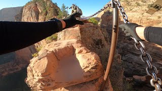
Most people stop at the saddle. The trail has great views from both sides, and lots of space to sit, eat lunch and take in the views from both the east and west sides of the canyon. From here you use chains and steep rock to climb out to Angel's Landing. On a busy day, you will find yourself waiting for others to come down as it often only allows single-file. If you go to early in spring, expect ice patches
We hope you've been enjoying Trailforks!
Create a FREE account to view all route reviews and much more.

| 1,913 ft |

Service Road Atlas is a free to use, community-driven service for viewing and creating reports on the numerous back-country service roads around B.C. and Alberta.
Save the current map location and zoom level as your default home location whenever this page is loaded.
Save| status | trail | date | condition | description |
|---|---|---|---|---|
Oct 12, 2026 @ 7:58am (America/Denver) Oct 12, 2026 | We hiked this in the rain. Bring gloves to keep your hands warm! |
 Trailforks & contributors