13.7 miles
Distance
1,752 ft
Climb
-1,751 ft
Descent
558 ft
High Point

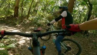
Big Parkies Loop with a good mix of climbs and rocky descents

Detailed Description
Big Parkies Loop is a 14 mile moderately popular intermediate route located near Nambour British Columbia. This mountain bike only route. This route includes 34 trails. This route climbs 1,752 ft with a max elevation of 558 ft then descends -1,751 ft.
Local Trail Association
Please consider joining or donating to the local riding association to support trail development & maintenance.

24 Reviews & Comments


We hope you've been enjoying Trailforks!

Create a FREE account to view route comments and much more.

Trails in Route

Road Rage3,281 ft
Tazer2,251 ft
Lush2 miles
Rocky Creek Road1,335 ft
Cancer Tree1 mile
T Track771 ft
Rock and Roll2,198 ft
Komine1,224 ft
Upper New Zealand141 ft
Shadowlands1,112 ft
Handlebar1,024 ft
Double Dab535 ft
Meadows1,102 ft
Fireline997 ft
Chairlift604 ft
Link Track587 ft
Roo Valley3,084 ft
Red Dog3,494 ft
Phoenix3,350 ft
Double Break3,064 ft
Roo Valley390 ft
M1633 ft
Dawecent997 ft
Upper New Zealand2,241 ft
Lower New Zealand554 ft
Rocket Man2,037 ft
Under Hill768 ft
Hoe Chi Ho2,297 ft

Details

  • Riding area
  • Primary Activity
    Mountain Bike
  • Difficulty rating
    Blue
  • Ridelogs
    2
More Stats for Big Parkies Loop mountain bike route
  • Avg time
    4 hr 55 min
  • Altitude change
    0 ft
  • Altitude min
    96 ft
  • Altitude start
    193 ft
  • Altitude end
    194 ft
  • Grade max
    -42.4%
  • Grade min
    42.6%
  • Distance climb
    6 miles
  • Distance down
    6 miles
  • Distance flat
    1 mile
no votes yet

  • view (1)
close
3D
Trail Conditions
  • Unknown
  • Snow Groomed
  • Snow Packed
  • Snow Covered
  • Snow Cover Inadequate
  • Freeze/thaw Cycle
  • Icy
  • Prevalent Mud
  • Wet
  • Variable
  • Ideal
  • Dry
  • Very Dry
Trail Flow (Ridden Direction)
Trailforks scans users ridelogs to determine the most popular direction each trail is ridden. A good flowing trail network will have most trails flowing in a single direction according to their intension.
The colour categories are based on what percentage of riders are riding a trail in its intended direction.
  • > 96%
  • > 90%
  • > 80%
  • > 70%
  • > 50%
  • < 50%
  • bi-directional trail
  • no data
Trail Last Ridden
Trailforks scans ridelogs to determine the last time a trail was ridden.
  • < 2 days
  • < 1 week
  • < 2 weeks
  • < 1 month
  • < 6 months
  • > 6 months
Trail Ridden Direction
The intended direction a trail should be ridden.
  • Downhill Only
  • Downhill Primary
  • Both Directions
  • Uphill Primary
  • Uphill Only
  • One Direction
Contribute Details
Colors indicate trail is missing specified detail.
  • Description
  • Photos
  • Description & Photos
  • Videos
Trail Popularity ?
Trailforks scans ridelogs to determine which trails are ridden the most in the last 9 months. Trails are compared with nearby trails in the same city region with a possible 25 colour shades. Think of this as a heatmap, more rides = more kinetic energy = warmer colors.
  • most popular
  • popular
  • less popular
  • not popular
ATV/ORV/OHV Filter
Max Vehicle Width
inches

Radar Time
x Activity Recordings
Trailforks users anonymized public ridelogs from the past 6 months.
  • mountain biking recent
  • mountain biking (>6 month)
  • hiking (1 year)
  • moto (1 year)
Activity Recordings
Trailforks users anonymized public skilogs from the past 12 months.
  • Downhill Ski
  • Backcountry Ski
  • Nordic Ski
  • Snowmobile
Winter Trails
Warning A routing network for winter maps does not exist. Selecting trails using the winter trails layer has been disabled.
x Missing Trails
Most Popular
Least Popular
Trails are colored based on popularity. The more popular a trail is, the more red. Less popular trails trend towards green.
Jump Magnitude Heatmap
Heatmap of where riders jump on trails. Zoom in to see individual jumps, click circles to view jump details.
Trails Deemphasized
Trails are shown in grey.
disable
Only show trails with NO bikes.
enable

Save the current map location and zoom level as your default home location whenever this page is loaded.

Save
Trail transparency
200
372
398
330
Lower New Zealand - MTB at Parklands
| comments: 0 | favs:
Feb 24, 2023
A bit slippy just after rain
| comments: 0 | favs:
Feb 24, 2023

Recent Trail Reports Along Route

statustraildateconditiondescription
Cancer Tree
Oct 8, 2023 @ 11:50pm
Oct 8, 2023
Perfect
Rock and Roll
Apr 14, 2023 @ 1:24am
Apr 14, 2023
Super dusty be careful
Road Rage
Apr 6, 2023 @ 11:06pm
Apr 6, 2023
Tazer
Apr 6, 2023 @ 4:06pm
Apr 6, 2023
Hoe Chi Ho
Feb 26, 2023 @ 7:58pm
Feb 26, 2023
more reports »
  • By Mattwilkins77 & contributors
  • #14795 - 920 views