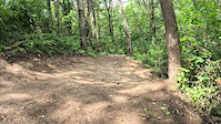
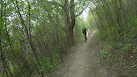
Blue Loop offers nothing but smooth and twisty trails throughout Memorial Park. This is a great route for fast and fun laps or just getting to know the bluff. There are plenty of wooden features and technically challenging paths scattered throughout to keep entertained and nothing too steep or difficult to clear. Branch out on black single track for an additional challenge and workout.
Local Trail Association
Red Wing Area Mountain Bike Organization (redwingmtb.com)Stats
-
Distance4 miles
-
Avg time41 min 1 sec
-
Altitude min995 ft
-
Altitude start1,008 ft
-
Altitude end1,007 ft
-
Climb329 ft
-
Descent-329 ft
-
Grade max-19.3%
-
Grade min20.3%
-
Distance climb1 mile
-
Distance down2 miles
-
Distance flat1 mile
We hope you've been enjoying Trailforks!
Create a FREE account to view route comments and much more.
Trails in Route
| 709 ft | |||||
| 3,123 ft | |||||
| 1,056 ft | |||||
| 2,523 ft | |||||
| 2,277 ft | |||||
| 2,582 ft | |||||
| 932 ft | |||||
| 932 ft | |||||
| 564 ft |
Details
- Featured
-
Riding area
-
Primary ActivityMountain Bike
-
Difficulty ratingBlue
-
Route TypeLoop
-
Bike typeXC
-
DirectionOne Direction
-
Physical ratingModerate
-
Ridelogs
Directions
- Walk northeast on Margaritaville.
- Continue for 500 meters.
- Keep straight to stay on Margaritaville.
- Continue for 30 meters.
- Keep left to take Yellow Brick Road.
- Continue for 30 meters.
- Turn left onto Margaritaville.
- Continue for 80 meters.
- Keep left to stay on Margaritaville.
- Continue for 2 kilometers.
- Walk south on All Along The Watch Tower.
- Continue for 100 meters.
- Turn right onto In Through The Out Door.
- Continue for 800 meters.
- Bear right onto Golf course access trail.
- Continue for 60 meters.
- Walk west on Crosstown Traffic.
- Continue for 400 meters.
- Turn left onto Proud Marry.
- Continue for 400 meters.
- Turn right to stay on Proud Marry.
- Continue for 100 meters.
- Turn left onto Access Trail - meadow three.
- Continue for 70 meters.
- Bear left onto Lay Down Sally.
- Continue for 800 meters.
- Turn right onto Crosstown Traffic.
- Continue for 80 meters.
- Walk southeast on Henke's Hollow.
- Continue for 200 meters.
- Turn right to stay on Henke's Hollow.
- Continue for 70 meters.
- Turn right onto Centerfold.
- Continue for less than 10 meters.
- Turn left onto Love Shack.
- Continue for 300 meters.
- Walk northeast on Margaritaville.
- Continue for 300 meters.
- Walk west on Parking lot access trail.
- Continue for 40 meters.
- Unknown
- Snow Groomed
- Snow Packed
- Snow Covered
- Snow Cover Partial
- Freeze/thaw Cycle
- Icy
- Prevalent Mud
- Wet
- Variable
- Ideal
- Dry
- Very Dry
The colour categories are based on what percentage of riders are riding a trail in its intended direction.
- > 96%
- > 90%
- > 80%
- > 70%
- > 50%
- < 50%
- bi-directional trail
- no data
- < 2 days
- < 1 week
- < 2 weeks
- < 1 month
- < 6 months
- > 6 months
- Downhill Only
- Downhill Primary
- Both Directions
- Uphill Primary
- Uphill Only
- One Direction
- Description
- Photos
- Description & Photos
- Videos
- most popular
- popular
- less popular
- not popular
Service Road Atlas is a free to use, community-driven service for viewing and creating reports on the numerous back-country service roads around B.C. and Alberta.
Save the current map location and zoom level as your default home location whenever this page is loaded.
Save- Singletrack
- Unpaved
Photos
Videos
Recent Trail Reports Along Route
- By 0oo0 & contributors
- #34708 - 894 views

