
Open in App
Get this route on your phone instantly.
Overview: This fun 4-mile loop offers a strenuous workout with rewarding views and diverse terrain.
Getting Started: The Cowboy Loop can be accessed from several locations along Avery-Sheep Ranch Road or Valley View Drive. All-weather access is available at the Avery Vista parking area along Avery-Sheep Ranch Road. Caution is advised on Valley View Drive during the wet season when the dirt road can become rutted and slick.
The Loop:
• The route is 99% single-track.
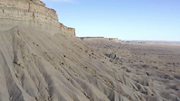
• Be prepared for significant elevation gain, exceeding 800 feet, with a steep climb out of the Cowell Creek drainage.
• Equestrians are encouraged to travel in a clockwise direction to climb (rather than descend) some tight switchbacks that can be slick when the tread is wet.
• Except for a few spots down in the Cowell Creek drainage, the trail generally drains well and remains in good condition year-round.
• While the exposed Cowell Creek drainage can get hot in summer, it provides pleasant conditions for sunny winter days.
Cautions:
• Poison oak is present throughout the area.
• No potable water is available along the route.
• Cell reception may not be reliable.
• Download a map to your phone for offline use before you go.
Highlights:
This loop combines the challenge of a steep climb with the beauty of varied landscapes, making it a worthwhile experience.
We hope you've been enjoying Trailforks!
Create a FREE account to view route comments and much more.
| 3,481 ft | |||||
| 3 miles | |||||
| 2,080 ft |

Service Road Atlas is a free to use, community-driven service for viewing and creating reports on the numerous back-country service roads around B.C. and Alberta.
Save the current map location and zoom level as your default home location whenever this page is loaded.
Save