15.0 miles
Distance
1,812 ft
Climb
-1,753 ft
Descent
1,432 ft
High Point

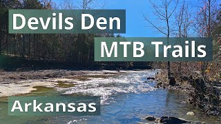
A compilation route of the majority of the trails. Helpful if you are just driving in for the day or stopping over in the middle of a road trip. This will let you see just about all of it.

Detailed Description
Devil's Den Compilation is a 15 mile popular intermediate route located near Winslow Arkansas. This mountain bike only route can be used both directions. This route includes 6 trails. This route climbs 1,812 ft with a max elevation of 1,432 ft then descends -1,753 ft.
Local Trail Association
Please consider joining or donating to the local riding association to support trail development & maintenance.
donate to earn trail karma!

12 Reviews & Comments


We hope you've been enjoying Trailforks!

Create a FREE account to view route comments and much more.

Trails in Route

Details

More Stats for Devil's Den Compilation mountain bike route
  • Avg time
    2 hr 12 min
  • Altitude min
    966 ft
  • Altitude start
    968 ft
  • Altitude end
    1,027 ft
  • Grade
    0.1%
  • Grade max
    -37.5%
  • Grade min
    27.2%
  • Distance climb
    6 miles
  • Distance down
    6 miles
  • Distance flat
    3 miles
no votes yet
close
3D
Trail Conditions
  • Unknown
  • Snow Groomed
  • Snow Packed
  • Snow Covered
  • Snow Cover Partial
  • Freeze/thaw Cycle
  • Icy
  • Prevalent Mud
  • Wet
  • Variable
  • Ideal
  • Dry
  • Very Dry
Trail Flow (Ridden Direction)
Trailforks scans users ridelogs to determine the most popular direction each trail is ridden. A good flowing trail network will have most trails flowing in a single direction according to their intension.
The colour categories are based on what percentage of riders are riding a trail in its intended direction.
  • > 96%
  • > 90%
  • > 80%
  • > 70%
  • > 50%
  • < 50%
  • bi-directional trail
  • no data
Trail Last Ridden
Trailforks scans ridelogs to determine the last time a trail was ridden.
  • < 2 days
  • < 1 week
  • < 2 weeks
  • < 1 month
  • < 6 months
  • > 6 months
Trail Ridden Direction
The intended direction a trail should be ridden.
  • Downhill Only
  • Downhill Primary
  • Both Directions
  • Uphill Primary
  • Uphill Only
  • One Direction
Contribute Details
Colors indicate trail is missing specified detail.
  • Description
  • Photos
  • Description & Photos
  • Videos
Trail Popularity ?
Trailforks scans ridelogs to determine which trails are ridden the most in the last 9 months. Trails are compared with nearby trails in the same city region with a possible 25 colour shades. Think of this as a heatmap, more rides = more kinetic energy = warmer colors.
  • most popular
  • popular
  • less popular
  • not popular
ATV/ORV/OHV Filter
Max Vehicle Width
inches
US Cell Coverage
Legend
cell carrier legend

Radar Time
x Activity Recordings
Trailforks users anonymized public ridelogs from the past 6 months.
  • mountain biking recent
  • mountain biking (>6 month)
  • hiking (1 year)
  • moto (1 year)
Activity Recordings
Trailforks users anonymized public skilogs from the past 12 months.
  • Downhill Ski
  • Backcountry Ski
  • Nordic Ski
  • Snowmobile
Winter Trails
Warning A routing network for winter maps does not exist. Selecting trails using the winter trails layer has been disabled.
x Missing Trails
Most Popular
Least Popular
Trails are colored based on popularity. The more popular a trail is, the more red. Less popular trails trend towards green.
Jump Magnitude Heatmap
Heatmap of where riders jump on trails. Zoom in to see individual jumps, click circles to view jump details.
Trails Deemphasized
Trails are shown in grey.
disable
Only show trails with NO bikes.
enable

Save the current map location and zoom level as your default home location whenever this page is loaded.

Save
Trail transparency
84
212
214
276
Fast XC Trails | Mountain Biking at...
Fast XC Trails | Mountain Biking at Devil's Den State Park, Arkansas
trail: Sparky
16:21 | 11 | comments: 0 | favs:
Dec 27, 2024

Recent Trail Reports Along Route

statustraildateconditiondescription
Dollar a Day
Dec 15, 2024 @ 12:50pm
Dec 15, 2024
Trails are mostly dry and clear, river crossings are a foot or more deep
All You Can Eat
Nov 21, 2024 @ 11:58am
Nov 21, 2024
We Can Take It
Nov 21, 2024 @ 11:58am
Nov 21, 2024
Sparky
Nov 21, 2024 @ 11:58am
Nov 21, 2024
Heavy leave coverage
Devils Racetrack
Aug 26, 2024 @ 4:55am
Aug 26, 2024
trees cleared reporter
more reports »
  • By cleaskTF Pro OCMTB & contributors
  • #34500 - 1,519 views