6.1 miles
Distance
1,558 ft
Climb
-1,456 ft
Descent
2,238 ft
High Point
103 ft
Altitude change
699 ft
Altitude min
699 ft
Altitude start
801 ft
Altitude end
0.3%
Grade
-60.3%
Grade max
58.5%
Grade min
4 miles
Distance climb
2 miles
Distance down
495 ft
Distance flat

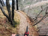
un allenamento su un bel sentiero con una durata di poco meno di un ora

Detailed Description
Gobbe e rientro is a 6 mile moderately popular intermediate route located near Gemona del Friuli. This mountain bike only route can be used one direction and has a moderate overall physical rating. This route includes 10 trails. This route climbs 1,558 ft with a max elevation of 2,238 ft then descends -1,456 ft.

Stats

  • Distance
    6 miles
  • Avg time
    3 hr 57 min
  • Altitude min
    699 ft
  • Altitude start
    699 ft
  • Altitude end
    801 ft
  • Climb
    1,558 ft
  • Descent
    -1,456 ft
  • Grade
    0.3%
  • Grade max
    -60.3%
  • Grade min
    58.5%
  • Distance climb
    4 miles
  • Distance down
    2 miles
  • Distance flat
    495 ft

6 Reviews & Comments


We hope you've been enjoying Trailforks!

Create a FREE account to view route comments and much more.

Trails in Route

Details

  • Riding area
  • Primary Activity
    Mountain Bike
  • Difficulty rating
    Blue
  • Route Type
    Loop
  • Bike type
    DH, AM, XC
  • Direction
    One Direction
  • Physical rating
    Moderate
  • Ridelogs
    3
no votes yet
close
3D
Trail Conditions
  • Unknown
  • Snow Groomed
  • Snow Packed
  • Snow Covered
  • Snow Cover Partial
  • Freeze/thaw Cycle
  • Icy
  • Prevalent Mud
  • Wet
  • Variable
  • Ideal
  • Dry
  • Very Dry
Trail Flow (Ridden Direction)
Trailforks scans users ridelogs to determine the most popular direction each trail is ridden. A good flowing trail network will have most trails flowing in a single direction according to their intension.
The colour categories are based on what percentage of riders are riding a trail in its intended direction.
  • > 96%
  • > 90%
  • > 80%
  • > 70%
  • > 50%
  • < 50%
  • bi-directional trail
  • no data
Trail Last Ridden
Trailforks scans ridelogs to determine the last time a trail was ridden.
  • < 2 days
  • < 1 week
  • < 2 weeks
  • < 1 month
  • < 6 months
  • > 6 months
Trail Ridden Direction
The intended direction a trail should be ridden.
  • Downhill Only
  • Downhill Primary
  • Both Directions
  • Uphill Primary
  • Uphill Only
  • One Direction
Contribute Details
Colors indicate trail is missing specified detail.
  • Description
  • Photos
  • Description & Photos
  • Videos
Trail Popularity ?
Trailforks scans ridelogs to determine which trails are ridden the most in the last 9 months. Trails are compared with nearby trails in the same city region with a possible 25 colour shades. Think of this as a heatmap, more rides = more kinetic energy = warmer colors.
  • most popular
  • popular
  • less popular
  • not popular
ATV/ORV/OHV Filter
Max Vehicle Width
inches
US Cell Coverage
Legend
cell carrier legend

Radar Time
Activity Recordings
Trailforks uses anonymized public activity data. ?
Activity Recordings
Trailforks uses anonymized public activity data. ?
Personal Heatmap
Activity Types
all / none
Options
2
Date range month
Winter Trails
Warning A routing network for winter maps does not exist. Selecting trails using the winter trails layer has been disabled.
Missing Trails
Most Popular
Least Popular
Trails are colored based on popularity. The more popular a trail is, the more red. Less popular trails trend towards green.
Jump Magnitude Heatmap
Heatmap of where riders jump on trails. Zoom in to see individual jumps, click circles to view jump details.
BC Backroad Status

Service Road Atlas is a free to use, community-driven service for viewing and creating reports on the numerous back-country service roads around B.C. and Alberta.

map legend
Slope Aspect
Direction the slope faces
Flat N NE E SE S SW W NW
Trails Deemphasized
Trails are shown in grey.
disable
Only show trails with no bike usage.
Enable
Suggested Layers
Based on selected activity type

    Save the current map location and zoom level as your default home location whenever this page is loaded.

    Save
    Trail transparency
    • Singletrack
    • Unpaved
    • Paved
    40
    55
    48
    163
    Malga Cuarnan and Gobbe Trail
    Malga Cuarnan and Gobbe Trail
    13:02 | 365 | comments: 0 | favs:
    Mar 9, 2024
    PANCHINE TRAIL AL BUIO! GEMONA DEL FRIULI MTB
    PANCHINE TRAIL AL BUIO! GEMONA DEL FRIULI MTB
    3:58 | 121 | comments: 0 | favs:
    Dec 21, 2023

    Recent Trail Reports Along Route

    statustraildateconditiondescription
    Salita a Sella Sant'Agnese
    Jun 23, 2026 @ 6:26pm (Europe/Rome)
    Jun 23, 2026
    Gobbe Trail
    Jun 14, 2026 @ 6:57pm (Europe/Rome)
    Jun 14, 2026
    Panchine lungo (ps3)
    Feb 25, 2026 @ 3:11pm (Europe/Ljubljana)
    Feb 25, 2026
    Sentiero perfetto
    Fornas
    Oct 1, 2025 @ 3:54pm (Europe/Ljubljana)
    Oct 1, 2025
    Cuarnan
    May 31, 2025 @ 8:57am
    May 31, 2025
    With that road altimeters are easy ;-)
    more reports »
    • By maxmisdarisTF Pro MGNR & contributors
    • #10342 - 1,284 views

    Hit the Trail

    Open in App

    Get this route on your phone instantly.

    Download Route

    Save to wishlist, Garmin & download.