

Open in App
Get this route on your phone instantly.
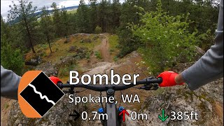
This loop allows intermediate riders to progress and inspire confidence in their downhill capability. The climb is easy and the downhill portion has a lot of fun features and diversity. Start by making your way Upchuck and the DH access road from Camp Sekani. At the top of the DH course you will start on bomber which is a black diamond but offers many optional routes for different levels of progression. On bomber you may experience some steep, technical rollers, a mellow wood roller, a fun bridge that you can ride over or jump, and 3 doubles all of which are optional. Where bomber meets Lower Old School, there is a few different line options so this section is fun to re-ride and get creative. Once you start down lower old school, you will encounter some intermediate technical terrain, an optional rock drop, and a really fun table top which leads you into the bottom of Stalin Grab. the bottom portion of Stalin Grab is extremely fun and consists of a few jumps, some fun rolling whoops that you can pump, some more intermediate tech and an optional gnarly rock roller. Stalin grab will spit you out at the bottom of Upchuck where you can start over if you please.
We hope you've been enjoying Trailforks!
Create a FREE account to view route comments and much more.
| 1,365 ft | |||||
| 2,159 ft | |||||
| 594 ft | |||||

Service Road Atlas is a free to use, community-driven service for viewing and creating reports on the numerous back-country service roads around B.C. and Alberta.
Save the current map location and zoom level as your default home location whenever this page is loaded.
Save