4.9 miles
Distance
98 ft
Climb
-103 ft
Descent
895 ft
High Point
-4 ft
Altitude change
835 ft
Altitude min
882 ft
Altitude start
879 ft
Altitude end
-0%
Grade
-13%
Grade max
7.6%
Grade min
1 mile
Distance climb
1 mile
Distance down
3 miles
Distance flat

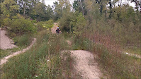
Smooth, fast, flowy trail with creek crossings, jumps, bridges, and many aquatic views. Begins with the Novice Loop then branches off for some more challenging terrain. A lot of up and down but keeps flowing the whole time

Detailed Description
Intermediate Loop is a 5 mile popular intermediate route located near Anderson Indiana. This mountain bike primary route can be used one direction and has a moderate overall physical rating. This route includes 3 trails. This route climbs 98 ft with a max elevation of 895 ft then descends -103 ft.
Local Trail Association
Local trail association
Rangeline Nature Preserve Mountain Biking
Please consider joining or donating to the local riding association to support trail development & maintenance.
Donate to earn trail karma!

Stats

  • Distance
    5 miles
  • Avg time
    23 min 44 sec
  • Altitude min
    835 ft
  • Altitude start
    882 ft
  • Altitude end
    879 ft
  • Climb
    98 ft
  • Descent
    -103 ft
  • Grade
    -0%
  • Grade max
    -13%
  • Grade min
    7.6%
  • Distance climb
    1 mile
  • Distance down
    1 mile
  • Distance flat
    3 miles

2 Reviews & Comments


We hope you've been enjoying Trailforks!

Create a FREE account to view route comments and much more.

Trails in Route

Novice Loop1 mile
Intermediate Loop4,551 ft
Vulcan2 miles

Details

  • Riding area
  • Primary Activity
    Mountain Bike
  • Other Activities
    • E-Bike
  • Difficulty rating
    Blue
  • Route Type
    Loop
  • eBike Allowed
  • Bike type
    AM, XC
  • Direction
    One Direction
  • Physical rating
    Moderate
  • Ridelogs
    93
Avg: 4.5 (2 votes)
close
3D
Trail Conditions
  • Unknown
  • Snow Groomed
  • Snow Packed
  • Snow Covered
  • Snow Cover Partial
  • Freeze/thaw Cycle
  • Icy
  • Prevalent Mud
  • Wet
  • Variable
  • Ideal
  • Dry
  • Very Dry
Trail Flow (Ridden Direction)
Trailforks scans users ridelogs to determine the most popular direction each trail is ridden. A good flowing trail network will have most trails flowing in a single direction according to their intension.
The colour categories are based on what percentage of riders are riding a trail in its intended direction.
  • > 96%
  • > 90%
  • > 80%
  • > 70%
  • > 50%
  • < 50%
  • bi-directional trail
  • no data
Trail Last Ridden
Trailforks scans ridelogs to determine the last time a trail was ridden.
  • < 2 days
  • < 1 week
  • < 2 weeks
  • < 1 month
  • < 6 months
  • > 6 months
Trail Ridden Direction
The intended direction a trail should be ridden.
  • Downhill Only
  • Downhill Primary
  • Both Directions
  • Uphill Primary
  • Uphill Only
  • One Direction
Contribute Details
Colors indicate trail is missing specified detail.
  • Description
  • Photos
  • Description & Photos
  • Videos
Trail Popularity ?
Trailforks scans ridelogs to determine which trails are ridden the most in the last 9 months. Trails are compared with nearby trails in the same city region with a possible 25 colour shades. Think of this as a heatmap, more rides = more kinetic energy = warmer colors.
  • most popular
  • popular
  • less popular
  • not popular
ATV/ORV/OHV Filter
Max Vehicle Width
inches
US Cell Coverage
Legend
cell carrier legend

Radar Time
Activity Recordings
Trailforks uses anonymized public activity data. ?
Activity Recordings
Trailforks uses anonymized public activity data. ?
Personal Heatmap
Activity Types
all / none
Options
2
Date range month
Winter Trails
Warning A routing network for winter maps does not exist. Selecting trails using the winter trails layer has been disabled.
Missing Trails
Most Popular
Least Popular
Trails are colored based on popularity. The more popular a trail is, the more red. Less popular trails trend towards green.
Jump Magnitude Heatmap
Heatmap of where riders jump on trails. Zoom in to see individual jumps, click circles to view jump details.
BC Backroad Status

Service Road Atlas is a free to use, community-driven service for viewing and creating reports on the numerous back-country service roads around B.C. and Alberta.

map legend
Slope Aspect
Direction the slope faces
Flat N NE E SE S SW W NW
Trails Deemphasized
Trails are shown in grey.
disable
Only show trails with no bike usage.
Enable
Suggested Layers
Based on selected activity type

    Save the current map location and zoom level as your default home location whenever this page is loaded.

    Save
    Trail transparency
    • Singletrack
    17
    14
    14
    11
    Rangeline nature preserve Mountain Bike park
    Rangeline nature preserve Mountain Bike park
    0:15 | 346 | comments: 0 | favs:
    Sep 6, 2017
    #rangeline #mtb #indiana #Indianapolis #usa #enduro

    Recent Trail Reports Along Route

    statustraildateconditiondescription
    Novice Loop
    Jun 21, 2026 @ 3:45pm (America/Indiana/Indianapolis)
    2 days
    Intermediate Loop
    Jun 21, 2026 @ 3:45pm (America/Indiana/Indianapolis)
    2 days
    Vulcan
    Jun 21, 2026 @ 3:45pm (America/Indiana/Indianapolis)
    2 days
    Good condition. Well trimmed.
    more reports »
    • By Warburrito & contributors
    • #925 - 2,724 views

    Hit the Trail

    Open in App

    Get this route on your phone instantly.

    Download Route

    Save to wishlist, Garmin & download.