1.4 miles
Distance
103 ft
Climb
-114 ft
Descent
3,296 ft
High Point

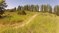
Kermit is an easy graded loop named for beginners. The loop is well marked by signs and easy to follow. All the trail features are easy and provide a good starting point for beginners.

Project Kermit was completed in 2016 with the help of our local Member of Northern Tablelands, Adam Marshall, Armidale Regional Council for the majority of the funding, University of New England and Ducats for the materials and assistance with the civils. #ridekermit

Detailed Description
Kermit is a 1 mile popular easy route located near Armidale. This mountain bike only route can be used one direction and has a easy overall physical rating. This route includes 7 trails. This route climbs 103 ft with a max elevation of 3,296 ft then descends -114 ft.
Route Supporters
Local Trail Association
Local trail association
New England Mountain Bikers (www.nemtb.com.au)
Please consider joining or donating to the local riding association to support trail development & maintenance.
donate to earn trail karma!

Comments


We hope you've been enjoying Trailforks!

Create a FREE account to view route comments and much more.

Trails in Route

Ivy League1,493 ft
Axe Head682 ft
Wimbledon177 ft
The Mogules958 ft
Berms Bypass184 ft
Zot Views722 ft
Flat Out1,463 ft

Details

  • Featured
  • Riding area
  • Primary Activity
    Mountain Bike
  • Difficulty rating
    Green
  • Route Type
    Loop
  • Bike type
    XC
  • Direction
    One Direction
  • Physical rating
    Easy
  • Ridelogs
    6
More Stats for Kermit mountain bike route
  • Avg time
    12 min 33 sec
  • Altitude min
    3,234 ft
  • Altitude start
    3,292 ft
  • Altitude end
    3,284 ft
  • Grade
    -0.1%
  • Grade max
    -13.9%
  • Grade min
    13.9%
  • Distance climb
    2,923 ft
  • Distance down
    3,448 ft
  • Distance flat
    889 ft
no votes yet
close
3D
Trail Conditions
  • Unknown
  • Snow Groomed
  • Snow Packed
  • Snow Covered
  • Snow Cover Partial
  • Freeze/thaw Cycle
  • Icy
  • Prevalent Mud
  • Wet
  • Variable
  • Ideal
  • Dry
  • Very Dry
Trail Flow (Ridden Direction)
Trailforks scans users ridelogs to determine the most popular direction each trail is ridden. A good flowing trail network will have most trails flowing in a single direction according to their intension.
The colour categories are based on what percentage of riders are riding a trail in its intended direction.
  • > 96%
  • > 90%
  • > 80%
  • > 70%
  • > 50%
  • < 50%
  • bi-directional trail
  • no data
Trail Last Ridden
Trailforks scans ridelogs to determine the last time a trail was ridden.
  • < 2 days
  • < 1 week
  • < 2 weeks
  • < 1 month
  • < 6 months
  • > 6 months
Trail Ridden Direction
The intended direction a trail should be ridden.
  • Downhill Only
  • Downhill Primary
  • Both Directions
  • Uphill Primary
  • Uphill Only
  • One Direction
Contribute Details
Colors indicate trail is missing specified detail.
  • Description
  • Photos
  • Description & Photos
  • Videos
Trail Popularity ?
Trailforks scans ridelogs to determine which trails are ridden the most in the last 9 months. Trails are compared with nearby trails in the same city region with a possible 25 colour shades. Think of this as a heatmap, more rides = more kinetic energy = warmer colors.
  • most popular
  • popular
  • less popular
  • not popular
ATV/ORV/OHV Filter
Max Vehicle Width
inches
US Cell Coverage
Legend
cell carrier legend

Radar Time
x Activity Recordings
Trailforks users anonymized public ridelogs from the past 6 months.
  • mountain biking recent
  • mountain biking (>6 month)
  • hiking (1 year)
  • moto (1 year)
Activity Recordings
Trailforks users anonymized public skilogs from the past 12 months.
  • Downhill Ski
  • Backcountry Ski
  • Nordic Ski
  • Snowmobile
Winter Trails
Warning A routing network for winter maps does not exist. Selecting trails using the winter trails layer has been disabled.
x Missing Trails
Most Popular
Least Popular
Trails are colored based on popularity. The more popular a trail is, the more red. Less popular trails trend towards green.
Jump Magnitude Heatmap
Heatmap of where riders jump on trails. Zoom in to see individual jumps, click circles to view jump details.
Trails Deemphasized
Trails are shown in grey.
disable
Only show trails with NO bikes.
enable

Save the current map location and zoom level as your default home location whenever this page is loaded.

Save
Trail transparency
22
SportUNE Track
SportUNE Track
trail: Axe Head
0:53 | 170 | comments: 0 | favs: 1
Aug 4, 2020
2017 MTB Championships in Armidale Australia, utilising parts of the SportUNE Track #NEMTB

Recent Trail Reports Along Route

statustraildateconditiondescription
Wimbledon
May 26, 2024 @ 11:23am
May 26, 2024
reporter
Zot Views
May 26, 2024 @ 4:22am
May 26, 2024
reporter
The Mogules
May 26, 2024 @ 4:22am
May 26, 2024
reporter
Ivy League
May 26, 2024 @ 4:22am
May 26, 2024
reporter
Flat Out
May 26, 2024 @ 4:22am
May 26, 2024
reporter
more reports »