1.6 miles
Distance
243 ft
Climb
-247 ft
Descent
941 ft
High Point
-5 ft
Altitude change
707 ft
Altitude min
715 ft
Altitude start
712 ft
Altitude end
-0.1%
Grade
-35%
Grade max
28.2%
Grade min
3,520 ft
Distance climb
3,819 ft
Distance down
1,204 ft
Distance flat

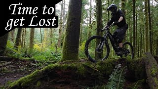
The Mainline Loop is a popular route through the Boxley Creek region. This route utilizes the two most popular trails in the area (Mainline and Ethan's) to make a climb-then-descend loop. The climb is all done on Mainline and ends at the top by the horse farm (you'll know it when you see it). The descent is all done on Ethan's Enduro Course, which offers a great flow with a few features and options. After exiting Ethan's onto the Snoqualmie Valley Trail, head downhill/Northeast to get back to the Mainline entrance.

Detailed Description
Mainline Loop is a 2 mile moderately popular intermediate route located near North Bend Washington. This mountain bike only route. This route includes 2 trails. This route climbs 243 ft with a max elevation of 941 ft then descends -247 ft.

Trail Issues on Route

  • Minor Issue / Yellow: 1 trail (newest: Mar 23, 2026)
Local Trail Association
Local trail association
Evergreen - Cascades to Sound Chapter (www.evergreenmtb.org)
Please consider joining or donating to the local riding association to support trail development & maintenance.
Donate to earn trail karma!

Stats

  • Distance
    2 miles
  • Altitude change
    -5 ft
  • Altitude min
    707 ft
  • Altitude start
    715 ft
  • Altitude end
    712 ft
  • Climb
    243 ft
  • Descent
    -247 ft
  • Grade
    -0.1%
  • Grade max
    -35%
  • Grade min
    28.2%
  • Distance climb
    3,520 ft
  • Distance down
    3,819 ft
  • Distance flat
    1,204 ft

Comments


We hope you've been enjoying Trailforks!

Create a FREE account to view route comments and much more.

Trails in Route

Details

  • Riding area
  • Primary Activity
    Mountain Bike
  • Difficulty rating
    Blue
no votes yet
close
3D
Trail Conditions
  • Unknown
  • Snow Groomed
  • Snow Packed
  • Snow Covered
  • Snow Cover Partial
  • Freeze/thaw Cycle
  • Icy
  • Prevalent Mud
  • Wet
  • Variable
  • Ideal
  • Dry
  • Very Dry
Trail Flow (Ridden Direction)
Trailforks scans users ridelogs to determine the most popular direction each trail is ridden. A good flowing trail network will have most trails flowing in a single direction according to their intension.
The colour categories are based on what percentage of riders are riding a trail in its intended direction.
  • > 96%
  • > 90%
  • > 80%
  • > 70%
  • > 50%
  • < 50%
  • bi-directional trail
  • no data
Trail Last Ridden
Trailforks scans ridelogs to determine the last time a trail was ridden.
  • < 2 days
  • < 1 week
  • < 2 weeks
  • < 1 month
  • < 6 months
  • > 6 months
Trail Ridden Direction
The intended direction a trail should be ridden.
  • Downhill Only
  • Downhill Primary
  • Both Directions
  • Uphill Primary
  • Uphill Only
  • One Direction
Contribute Details
Colors indicate trail is missing specified detail.
  • Description
  • Photos
  • Description & Photos
  • Videos
Trail Popularity ?
Trailforks scans ridelogs to determine which trails are ridden the most in the last 9 months. Trails are compared with nearby trails in the same city region with a possible 25 colour shades. Think of this as a heatmap, more rides = more kinetic energy = warmer colors.
  • most popular
  • popular
  • less popular
  • not popular
ATV/ORV/OHV Filter
Max Vehicle Width
inches
US Cell Coverage
Legend
cell carrier legend

Radar Time
Activity Recordings
Trailforks uses anonymized public activity data. ?
Activity Recordings
Trailforks uses anonymized public activity data. ?
Personal Heatmap
Activity Types
all / none
Options
2
Date range month
Winter Trails
Warning A routing network for winter maps does not exist. Selecting trails using the winter trails layer has been disabled.
Missing Trails
Most Popular
Least Popular
Trails are colored based on popularity. The more popular a trail is, the more red. Less popular trails trend towards green.
Jump Magnitude Heatmap
Heatmap of where riders jump on trails. Zoom in to see individual jumps, click circles to view jump details.
BC Backroad Status

Service Road Atlas is a free to use, community-driven service for viewing and creating reports on the numerous back-country service roads around B.C. and Alberta.

map legend
Slope Aspect
Direction the slope faces
Flat N NE E SE S SW W NW
Trails Deemphasized
Trails are shown in grey.
disable
Only show trails with no bike usage.
Enable
Suggested Layers
Based on selected activity type

    Save the current map location and zoom level as your default home location whenever this page is loaded.

    Save
    Trail transparency
    • Singletrack
    youtuber A Small Gem of a Trail System || Boxley Creek
    A Small Gem of a Trail System || Boxley Creek
    trail: Mainline
    8:31 | 158 | comments: 0 | favs:
    Nov 18, 2024
    youtuber A Small Gem of a Trail System || Boxley Creek
    A Small Gem of a Trail System || Boxley Creek
    8:31 | 229 | comments: 0 | favs:
    Nov 18, 2024

    Recent Trail Reports Along Route

    statustraildateconditiondescription
    Ethan's Enduro Course
    Mar 27, 2026 @ 8:38am (America/Los_Angeles)
    Mar 27, 2026
    Downs and snow laden brush cleared.
    Mainline
    Mar 23, 2026 @ 12:41pm (America/Vancouver)
    Mar 23, 2026
    Still needs logging tread work, buts downs cleared to top.
    more reports »
    • By YotztTF Pro & contributors
    • #50506 - 410 views

    Hit the Trail

    Open in App

    Get this route on your phone instantly.

    Download Route

    Save to wishlist, Garmin & download.