
Open in App
Get this route on your phone instantly.
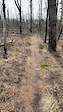
Follow the Green to the blue/orange and follow orange dots back to blue to green for what is measured 19mi but shows at 17mi on most GPS devices. It is a technical trail only in the amount of tight twisty sections.
We hope you've been enjoying Trailforks!
Create a FREE account to view route comments and much more.
| 57 miles |

Service Road Atlas is a free to use, community-driven service for viewing and creating reports on the numerous back-country service roads around B.C. and Alberta.
Save the current map location and zoom level as your default home location whenever this page is loaded.
Save