10.3 miles
Distance
1,482 ft
Climb
-1,505 ft
Descent
641 ft
High Point
-8 ft
Altitude change
148 ft
Altitude min
260 ft
Altitude start
253 ft
Altitude end
-40.3%
Grade max
61.6%
Grade min
4 miles
Distance climb
4 miles
Distance down
2 miles
Distance flat

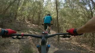
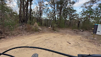
Twice the fun Local rider Panda knows how to optimise the descents!
Make your way up Power Up for a run down Salt Lizard - a flowy descent with a slight pedal traverse into more flow.
Head back up to the Flow Zone via Afterburner for a lap down Straight Six - one of the fastest trails in the park!

Detailed Description
Panda's Loop is a 10 mile popular intermediate route located near Eden. This mountain bike only route. This route includes 6 trails. This route climbs 1,482 ft with a max elevation of 641 ft then descends -1,505 ft.

Trail Issues on Route

  • Significant Issue / Amber: 1 trail (newest: Mar 27, 2026)
  • Minor Issue / Yellow: 1 trail (newest: Feb 13, 2026)
Local Trail Association
Local trail association
Eden Mountain Bike Club Inc. (www.gravityeden.com.au)
Please consider joining or donating to the local riding association to support trail development & maintenance.
Donate to earn trail karma!

Stats

  • Distance
    10 miles
  • Altitude change
    -8 ft
  • Altitude min
    148 ft
  • Altitude start
    260 ft
  • Altitude end
    253 ft
  • Climb
    1,482 ft
  • Descent
    -1,505 ft
  • Grade max
    -40.3%
  • Grade min
    61.6%
  • Distance climb
    4 miles
  • Distance down
    4 miles
  • Distance flat
    2 miles

15 Reviews & Comments


We hope you've been enjoying Trailforks!

Create a FREE account to view route comments and much more.

Trails in Route

Frenzy774 ft
Thunder Box1 mile
Tumbles4,432 ft
Salt Lizard4,390 ft
After Burner2 miles
Straight Six2 miles

Details

Directions

  1. Walk southeast on Frenzy.
  2. Continue for 200 meters.
  3. Turn left onto Fore.
  4. Continue for 700 meters.
  5. Keep left to take Thunder Box.
  6. Continue for 1.5 kilometers.
  7. Make a sharp left onto Golfcourse Trail.
  8. Continue for 1.5 kilometers.
  9. Bear left onto Cruiser Tumbles Link.
  10. Continue for less than 10 meters.
  11. Turn left onto Cruiser.
  12. Continue for 1.5 kilometers.
  13. Keep left to take Powerup.
  14. Continue for 100 meters.
  15. Turn left to stay on Powerup.
  16. Continue for 2 kilometers.
  17. Walk east on Salt Lizard.
  18. Continue for 1.5 kilometers.
  19. Bear left onto Cruiser.
  20. Continue for 200 meters.
  21. Turn left onto Tumbles.
  22. Continue for 1 kilometer.
  23. Walk southwest on After Burner.
  24. Continue for 1 kilometer.
no votes yet
close
3D
Trail Conditions
  • Unknown
  • Snow Groomed
  • Snow Packed
  • Snow Covered
  • Snow Cover Partial
  • Freeze/thaw Cycle
  • Icy
  • Prevalent Mud
  • Wet
  • Variable
  • Ideal
  • Dry
  • Very Dry
Trail Flow (Ridden Direction)
Trailforks scans users ridelogs to determine the most popular direction each trail is ridden. A good flowing trail network will have most trails flowing in a single direction according to their intension.
The colour categories are based on what percentage of riders are riding a trail in its intended direction.
  • > 96%
  • > 90%
  • > 80%
  • > 70%
  • > 50%
  • < 50%
  • bi-directional trail
  • no data
Trail Last Ridden
Trailforks scans ridelogs to determine the last time a trail was ridden.
  • < 2 days
  • < 1 week
  • < 2 weeks
  • < 1 month
  • < 6 months
  • > 6 months
Trail Ridden Direction
The intended direction a trail should be ridden.
  • Downhill Only
  • Downhill Primary
  • Both Directions
  • Uphill Primary
  • Uphill Only
  • One Direction
Contribute Details
Colors indicate trail is missing specified detail.
  • Description
  • Photos
  • Description & Photos
  • Videos
Trail Popularity ?
Trailforks scans ridelogs to determine which trails are ridden the most in the last 9 months. Trails are compared with nearby trails in the same city region with a possible 25 colour shades. Think of this as a heatmap, more rides = more kinetic energy = warmer colors.
  • most popular
  • popular
  • less popular
  • not popular
ATV/ORV/OHV Filter
Max Vehicle Width
inches
US Cell Coverage
Legend
cell carrier legend

Radar Time
Activity Recordings
Trailforks uses anonymized public activity data. ?
Activity Recordings
Trailforks uses anonymized public activity data. ?
Personal Heatmap
Activity Types
all / none
Options
2
Date range month
Winter Trails
Warning A routing network for winter maps does not exist. Selecting trails using the winter trails layer has been disabled.
Missing Trails
Most Popular
Least Popular
Trails are colored based on popularity. The more popular a trail is, the more red. Less popular trails trend towards green.
Jump Magnitude Heatmap
Heatmap of where riders jump on trails. Zoom in to see individual jumps, click circles to view jump details.
BC Backroad Status

Service Road Atlas is a free to use, community-driven service for viewing and creating reports on the numerous back-country service roads around B.C. and Alberta.

map legend
Slope Aspect
Direction the slope faces
Flat N NE E SE S SW W NW
Trails Deemphasized
Trails are shown in grey.
disable
Only show trails with no bike usage.
Enable
Suggested Layers
Based on selected activity type

    Save the current map location and zoom level as your default home location whenever this page is loaded.

    Save
    Trail transparency
    • Singletrack
    39
    49
    61
    41
    Gravity Eden Mountain Bike Park - Straight Six
    Gravity Eden Mountain Bike Park - Straight Six
    9:43 | 276 | comments: 0 | favs:
    Aug 4, 2024
    Straight Six WITH ALL THE JUMPS
    Straight Six WITH ALL THE JUMPS
    3:22 | 406 | comments: 0 | favs:
    Oct 10, 2023
    @GARTH

    Recent Trail Reports Along Route

    statustraildateconditiondescription
    Straight Six
    Mar 28, 2026 @ 1:26pm (Australia/Sydney)
    Mar 27, 2026
    2 points with very large trees down blocking entire trail
    Tumbles
    Feb 14, 2026 @ 1:38pm (Australia/Sydney)
    Feb 13, 2026
    Tumbles up she oak across track (lengthy) hand or chain. JB solo couldn't move. reporter
    Thunder Box
    Jan 20, 2026 @ 10:20am (Australia/Sydney)
    Jan 19, 2026
    reporter
    Salt Lizard
    Jan 20, 2026 @ 10:20am (Australia/Sydney)
    Jan 19, 2026
    reporter
    Frenzy
    Jan 20, 2026 @ 10:20am (Australia/Sydney)
    Jan 19, 2026
    reporter
    more reports »
    • By jacqhedditchTF Pro EMTBC & contributors
    • #55426 - 526 views

    Hit the Trail

    Open in App

    Get this route on your phone instantly.

    Download Route

    Save to wishlist, Garmin & download.