
Open in App
Get this route on your phone instantly.
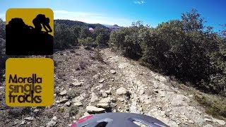
La ombría del Riu de les Corces ofrece grandes posibilidades, hermosos caminos centenarios con excelentes atractivos para descender. La Pasana es uno de ellos, muy bueno, variado, bello y divertido. El regreso, desde Vallibona, toma el top track "Mundo Perdido" en sentido ascendente, que nos obligará a tomar la bici al hombro en más de una ocasión, pero que para quienes no le hagan ascos al porteo, ofrece un recorrido precioso, estimulante y exigente, una ruta de genuino Enduro Mtb. Un aliciente más es la posibilidad de darse un buen baño, en un paraje tan espectacular como la fuente del Molí Rico. El regreso a Morella por Red Hot es recurrente en nuestras rutas mtb por el sector, pero a nadie le importa repetir en este gozadero.
ervicios
En Vallibona dispondremos de un punto fiable de agua tratada. Además hay bar Restaurant, (si bien cierran un día a la semana por descanso), y tienda de ultramarinos, que tampoco está abierta todos los días.
Es INDISPENSABLE CARGAR AGUA EN VALLIBONA. Aparte, a la altura del Molí Rico se pasa junto a una fuente de AGUA NO TRATADA que conserva cierto caudal todo el año y que no sabemos que haya tenido nunca problemas de potabilidad.
La ruta incluye TRAMOS DE PORTEO.
Porcentaje de senda: 65%
Porcentaje de pista: 20%
Porcentaje de asfalto: 15%
Balizada Centre BTT: No
Duración estimada: De 5 a 6 h.
We hope you've been enjoying Trailforks!
Create a FREE account to view route comments and much more.
| 358 ft | |||||
| 1,191 ft | |||||
| 1,522 ft | |||||
| 1 mile | |||||
| 2,579 ft | |||||
| 5 miles | |||||
| 5,141 ft | |||||
| 338 ft | |||||
| 2,559 ft | |||||
| 3,819 ft |

Service Road Atlas is a free to use, community-driven service for viewing and creating reports on the numerous back-country service roads around B.C. and Alberta.
Save the current map location and zoom level as your default home location whenever this page is loaded.
Save