
Open in App
Get this route on your phone instantly.
Note: Phase 1 is directional by day of week. The trail is ridden clockwise on Tuesdays, Thursdays and Sundays and counterclockwise on Mondays, Wednesdays, Fridays and Saturdays. There is signage at the trail heads indicating which direction to start. Trail runners and hikers should travel in the opposite direction.
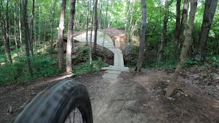
The granddaddy of Central Ohio mountain biking, Phase 1, P1 for short, is COMBO's first trail. P1 was built in the early 1990s and is still a favorite for Central Ohio riders. This 5.5-mile trail is designated as a beginner/intermediate trail. There are plenty of roots, bridges, and an optional creek crossing to keep the ride interesting. P1 is considered by many to be the most technically demanding trail in central Ohio solely because of the roots. Bridges are relatively low & wide (compared to P2) but the roots are non-stop
This trail is particularly impacted by wet weather due its heavy usage and soil composition, so please give the trail a couple days to dry out after rain. The normal riding direction on the trail is counterclockwise. Be sure to check COMBO's trail conditions updates before heading out to use the trail.
We hope you've been enjoying Trailforks!
Create a FREE account to view route comments and much more.
| 6 miles |

Service Road Atlas is a free to use, community-driven service for viewing and creating reports on the numerous back-country service roads around B.C. and Alberta.
Save the current map location and zoom level as your default home location whenever this page is loaded.
Save| status | trail | date | condition | description |
|---|---|---|---|---|
Jun 16, 2026 @ 7:48pm (America/New_York) Jun 16, 2026 | Rework |