

Open in App
Get this route on your phone instantly.
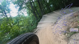
Alum Creek Phase 2 (P2) has quickly become the most heavily ridden trail in Central Ohio. Phase 2 was originally designed for more advanced riders and features some relatively narrow bridges ("skinnies"). As a newer trail than P1, it tends to flow a little better & not have quite as many exposed roots. Some technical sections are optional, but newer riders should be prepared for challenges including numerous bridges and logovers.
P2 is home to a few longer bridges, a banked wall turn & a signature section of elevated trail. At ~5.5 miles, it's ridden as one continuous loop and is a shared trail with the occasional hiker or trail runner.
Phase 2 will usually dry more quickly than Phase 1 after rain, but still may take a day or two to be ready. Be sure to check COMBO's trail conditions updates before heading out to ride.
We hope you've been enjoying Trailforks!
Create a FREE account to view route comments and much more.
| 5 miles |

Service Road Atlas is a free to use, community-driven service for viewing and creating reports on the numerous back-country service roads around B.C. and Alberta.
Save the current map location and zoom level as your default home location whenever this page is loaded.
Save| status | trail | date | condition | description |
|---|---|---|---|---|
Jun 14, 2026 @ 11:40am (America/New_York) Jun 14, 2026 |