11.3 miles
Distance
1,952 ft
Climb
-1,951 ft
Descent
2 miles
High Point
7,412 ft
Altitude min
7,559 ft
Altitude start
7,559 ft
Altitude end
-32.8%
Grade max
45.1%
Grade min
6 miles
Distance climb
5 miles
Distance down
4,436 ft
Distance flat

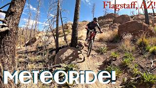
11 mile loop featuring both of Flagstaff's newest downhill only trails Full Sail is a DH only jumpline/flow trail, and Meteoride is a DH only Black Diamond tech descent.

Detailed Description
Pure Loop is a 11 mile popular expert route located near Flagstaff Arizona. This mountain bike only route can be used one direction and has a moderate overall physical rating. This route includes 4 trails. This route climbs 1,952 ft with a max elevation of 8,838 ft then descends -1,951 ft.

Trail Issues on Route

  • Minor Issue / Yellow: 1 trail (newest: Jun 19, 2026)
Local Trail Association
Local trail association
Flagstaff Biking Organization (flagstaffbiking.org)
Please consider joining or donating to the local riding association to support trail development & maintenance.
Donate to earn trail karma!

Stats

  • Distance
    11 miles
  • Altitude min
    7,412 ft
  • Altitude start
    7,559 ft
  • Altitude end
    7,559 ft
  • Climb
    1,952 ft
  • Descent
    -1,951 ft
  • Grade max
    -32.8%
  • Grade min
    45.1%
  • Distance climb
    6 miles
  • Distance down
    5 miles
  • Distance flat
    4,436 ft

45 Reviews & Comments


We hope you've been enjoying Trailforks!

Create a FREE account to view route comments and much more.

Trails in Route

Down Under2,822 ft
Full Sail3 miles
Abalone1,759 ft
Meteoride1 mile

Details

  • Riding area
  • Primary Activity
    Mountain Bike
  • Difficulty rating
    Black Diamond
  • Route Type
    Loop
  • eBike Allowed
  • Bike type
    AM
  • Direction
    One Direction
  • Physical rating
    Moderate
Avg: 3.75 (4 votes)
close
3D
Trail Conditions
  • Unknown
  • Snow Groomed
  • Snow Packed
  • Snow Covered
  • Snow Cover Partial
  • Freeze/thaw Cycle
  • Icy
  • Prevalent Mud
  • Wet
  • Variable
  • Ideal
  • Dry
  • Very Dry
Trail Flow (Ridden Direction)
Trailforks scans users ridelogs to determine the most popular direction each trail is ridden. A good flowing trail network will have most trails flowing in a single direction according to their intension.
The colour categories are based on what percentage of riders are riding a trail in its intended direction.
  • > 96%
  • > 90%
  • > 80%
  • > 70%
  • > 50%
  • < 50%
  • bi-directional trail
  • no data
Trail Last Ridden
Trailforks scans ridelogs to determine the last time a trail was ridden.
  • < 2 days
  • < 1 week
  • < 2 weeks
  • < 1 month
  • < 6 months
  • > 6 months
Trail Ridden Direction
The intended direction a trail should be ridden.
  • Downhill Only
  • Downhill Primary
  • Both Directions
  • Uphill Primary
  • Uphill Only
  • One Direction
Contribute Details
Colors indicate trail is missing specified detail.
  • Description
  • Photos
  • Description & Photos
  • Videos
Trail Popularity ?
Trailforks scans ridelogs to determine which trails are ridden the most in the last 9 months. Trails are compared with nearby trails in the same city region with a possible 25 colour shades. Think of this as a heatmap, more rides = more kinetic energy = warmer colors.
  • most popular
  • popular
  • less popular
  • not popular
ATV/ORV/OHV Filter
Max Vehicle Width
inches
US Cell Coverage
Legend
cell carrier legend

Radar Time
Activity Recordings
Trailforks uses anonymized public activity data. ?
Activity Recordings
Trailforks uses anonymized public activity data. ?
Personal Heatmap
Activity Types
all / none
Options
2
Date range month
Winter Trails
Warning A routing network for winter maps does not exist. Selecting trails using the winter trails layer has been disabled.
Missing Trails
Most Popular
Least Popular
Trails are colored based on popularity. The more popular a trail is, the more red. Less popular trails trend towards green.
Jump Magnitude Heatmap
Heatmap of where riders jump on trails. Zoom in to see individual jumps, click circles to view jump details.
BC Backroad Status

Service Road Atlas is a free to use, community-driven service for viewing and creating reports on the numerous back-country service roads around B.C. and Alberta.

map legend
Slope Aspect
Direction the slope faces
Flat N NE E SE S SW W NW
Trails Deemphasized
Trails are shown in grey.
disable
Only show trails with no bike usage.
Enable
Suggested Layers
Based on selected activity type

    Save the current map location and zoom level as your default home location whenever this page is loaded.

    Save
    Trail transparency
    • Singletrack
    61
    51
    63
    44
    Meteoride Lived Up to the Hype! Fast Full Run!...
    Meteoride Lived Up to the Hype! Fast Full Run! Flagstaff, AZ!
    trail: Meteoride
    8:22 | 8 | comments: 0 | favs:
    Jun 14, 2026
    Flagstaff Enduro: STAGE 2
    Flagstaff Enduro: STAGE 2
    trail: Meteoride
    7:13 | 111 | comments: 0 | favs:
    Nov 1, 2025

    Recent Trail Reports Along Route

    statustraildateconditiondescription
    Abalone
    Jun 19, 2026 @ 9:04am (America/Phoenix)
    2 days
    Full Sail
    Jun 19, 2026 @ 9:04am (America/Phoenix)
    2 days
    Ideal
    Meteoride
    Mar 22, 2026 @ 10:10am (America/Phoenix)
    Mar 22, 2026
    Down Under
    May 19, 2025 @ 12:09pm
    May 19, 2025
    more reports »
    • By piperkeltyTF Pro & contributors
    • #61103 - 1,298 views

    Hit the Trail

    Open in App

    Get this route on your phone instantly.

    Download Route

    Save to wishlist, Garmin & download.