12.7 miles
Distance
1,682 ft
Climb
-1,659 ft
Descent
601 ft
High Point
22 ft
Altitude change
104 ft
Altitude min
104 ft
Altitude start
128 ft
Altitude end
-46.9%
Grade max
29.3%
Grade min
6 miles
Distance climb
5 miles
Distance down
1 mile
Distance flat

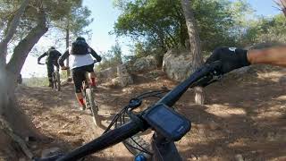
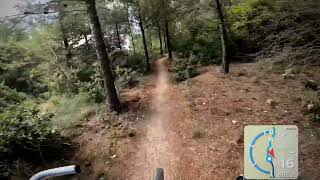
An offical KKL route, marked in Yellow, climbs are not steep, it has no technical features.
Most of the route is shaded.

Detailed Description
Ridge line loop is a 13 mile popular easy route located near Ofer Forest. This mountain bike only route can be used one direction and has a moderate overall physical rating. This route includes 13 trails. This route climbs 1,682 ft with a max elevation of 601 ft then descends -1,659 ft.
Route Supporters

Stats

  • Distance
    13 miles
  • Avg time
    1 hr 48 min
  • Altitude min
    104 ft
  • Altitude start
    104 ft
  • Altitude end
    128 ft
  • Climb
    1,682 ft
  • Descent
    -1,659 ft
  • Grade max
    -46.9%
  • Grade min
    29.3%
  • Distance climb
    6 miles
  • Distance down
    5 miles
  • Distance flat
    1 mile

Comments


We hope you've been enjoying Trailforks!

Create a FREE account to view route comments and much more.

Trails in Route

Burial Cave778 ft
Forest Road3,146 ft
Ridge line2 miles
Dushbag1,204 ft
Rabbit - Upper735 ft
Ridge line2,936 ft
Ridge line919 ft
Ridge line2,818 ft
Ridge line3 miles
Forest Road4,573 ft
Ridge line1 mile
Ridge line1,585 ft
Ridge line5,020 ft

Details

  • Riding area
  • Primary Activity
    Mountain Bike
  • AKA
    רכס השלוחה
  • Difficulty rating
    Green
  • Route Type
    Loop
  • Bike type
    AM, XC
  • Direction
    One Direction
  • Physical rating
    Moderate
  • Ridelogs
    296
Avg: 5 (1 votes)
close
3D
Trail Conditions
  • Unknown
  • Snow Groomed
  • Snow Packed
  • Snow Covered
  • Snow Cover Partial
  • Freeze/thaw Cycle
  • Icy
  • Prevalent Mud
  • Wet
  • Variable
  • Ideal
  • Dry
  • Very Dry
Trail Flow (Ridden Direction)
Trailforks scans users ridelogs to determine the most popular direction each trail is ridden. A good flowing trail network will have most trails flowing in a single direction according to their intension.
The colour categories are based on what percentage of riders are riding a trail in its intended direction.
  • > 96%
  • > 90%
  • > 80%
  • > 70%
  • > 50%
  • < 50%
  • bi-directional trail
  • no data
Trail Last Ridden
Trailforks scans ridelogs to determine the last time a trail was ridden.
  • < 2 days
  • < 1 week
  • < 2 weeks
  • < 1 month
  • < 6 months
  • > 6 months
Trail Ridden Direction
The intended direction a trail should be ridden.
  • Downhill Only
  • Downhill Primary
  • Both Directions
  • Uphill Primary
  • Uphill Only
  • One Direction
Contribute Details
Colors indicate trail is missing specified detail.
  • Description
  • Photos
  • Description & Photos
  • Videos
Trail Popularity ?
Trailforks scans ridelogs to determine which trails are ridden the most in the last 9 months. Trails are compared with nearby trails in the same city region with a possible 25 colour shades. Think of this as a heatmap, more rides = more kinetic energy = warmer colors.
  • most popular
  • popular
  • less popular
  • not popular
ATV/ORV/OHV Filter
Max Vehicle Width
inches
US Cell Coverage
Legend
cell carrier legend

Radar Time
Activity Recordings
Trailforks uses anonymized public activity data. ?
Activity Recordings
Trailforks uses anonymized public activity data. ?
Personal Heatmap
Activity Types
all / none
Options
2
Date range month
Winter Trails
Warning A routing network for winter maps does not exist. Selecting trails using the winter trails layer has been disabled.
Missing Trails
Most Popular
Least Popular
Trails are colored based on popularity. The more popular a trail is, the more red. Less popular trails trend towards green.
Jump Magnitude Heatmap
Heatmap of where riders jump on trails. Zoom in to see individual jumps, click circles to view jump details.
BC Backroad Status

Service Road Atlas is a free to use, community-driven service for viewing and creating reports on the numerous back-country service roads around B.C. and Alberta.

map legend
Slope Aspect
Direction the slope faces
Flat N NE E SE S SW W NW
Trails Deemphasized
Trails are shown in grey.
disable
Only show trails with no bike usage.
Enable
Suggested Layers
Based on selected activity type

    Save the current map location and zoom level as your default home location whenever this page is loaded.

    Save
    Trail transparency
    • Singletrack
    • Unpaved
    סינגל השלוחה עופר   | OFER...
    סינגל השלוחה עופר | OFER Ridge line Singletrack
    7:47 | 191 | comments: 0 | favs:
    Oct 27, 2020
    The Cliff singletrack
    The Cliff singletrack
    trail: Ridge line
    0:58 | 189 | comments: 0 | favs:
    Jun 19, 2022

    Recent Trail Reports Along Route

    statustraildateconditiondescription
    Rabbit - Upper
    Feb 20, 2026 @ 9:01am (Asia/Jerusalem)
    Feb 19, 2026
    Ridge line
    Feb 20, 2026 @ 9:01am (Asia/Jerusalem)
    Feb 19, 2026
    Ridge line
    Feb 20, 2026 @ 9:01am (Asia/Jerusalem)
    Feb 19, 2026
    Dushbag
    Feb 20, 2026 @ 9:01am (Asia/Jerusalem)
    Feb 19, 2026
    Forest Road
    Feb 20, 2026 @ 9:01am (Asia/Jerusalem)
    Feb 19, 2026
    more reports »
    • By ziv2102TF Pro TRAILFORKS & contributors
    • #18777 - 2,159 views

    Hit the Trail

    Open in App

    Get this route on your phone instantly.

    Download Route

    Save to wishlist, Garmin & download.