

Open in App
Get this route on your phone instantly.
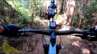
A great blue loop for intermediate riders. Nothing to scary, but still a few little challenges with a variety of trails, from tight and techy, to open and flowy (well as flowy as riverhead gets).
We hope you've been enjoying Trailforks!
Create a FREE account to view route comments and much more.
| 1,762 ft | |||||
| 791 ft | |||||
| 1,306 ft | |||||
| 610 ft | |||||
| 2,749 ft | |||||
| 633 ft | |||||
| 3,114 ft | |||||
| 217 ft | |||||
| 2,549 ft | |||||
| 2,992 ft | |||||
| 453 ft | |||||
| 1,280 ft | |||||
| 1,335 ft | |||||
| 1,781 ft | |||||
| 610 ft | |||||
| 397 ft | |||||
| 2,982 ft | |||||
| 1,145 ft | |||||
| 1,483 ft | |||||
| 2,005 ft | |||||
| 771 ft |

Service Road Atlas is a free to use, community-driven service for viewing and creating reports on the numerous back-country service roads around B.C. and Alberta.
Save the current map location and zoom level as your default home location whenever this page is loaded.
Save| status | trail | date | condition | description |
|---|---|---|---|---|
Mar 7, 2026 @ 8:56am (Pacific/Auckland) Mar 6, 2026 | In great condition. Best month for riding. |