33.9 miles
Distance
4,272 ft
Climb
-4,270 ft
Descent
1 mile
High Point
1 ft
Altitude change
5,322 ft
Altitude min
5,322 ft
Altitude start
5,322 ft
Altitude end
-56.7%
Grade max
71.3%
Grade min
18 miles
Distance climb
13 miles
Distance down
3 miles
Distance flat

The Royal Loop
30+ mile loop starting and ending in Cañon City which utilizes the Royal Gorge Bridge. Additional singletrack planned to reduce dirt road miles - keep checking here for updates as we work through BLM approval. (UPDATE JULY 2025: After working with the BLM since June 2021, the BLM has stated that they no longer have the capacity to continue on with the approval process for additional single track trail to connect County Road 3 to the City's Royal Gorge Park.) Options for additional miles available in both the South Cañon and Royal Gorge Park trail systems. Most people will prefer to ride this loop clockwise, though counter-clockwise goes it just involves a very serious climb up Royal Cascade and losing notable elevation on roads.

Things to keep in mind:
- The Royal Gorge Bridge requires a fee to cross - see below for more information.
-Climbing Hard Time is a reasonable approach to reduce road miles (only 1 though) but it is technical and not everyone's cup of tea.
- Untreated water is available in Grape Creek year-round (mile 14.2 on route as shown). Treated water is available at the Royal Gorge Bridge (mile 21.7 on route as shown). Food - and beer - available at the Royal Gorge Bridge.
- Route currently involves at least 4 miles of dirt road and 3 miles of paved road (well, mostly paved anyhow). In the clockwise direction these are climbed.
- Notable areas of clay soils. Do not use when wet. Do not use muddy trails in general, but those clay soils sections will suck the life from you and turn a bike into nothing more useful than a boat anchor.
- Royal Cascade Trail (key segment for full connection) is closed to all use in the months of June and July (for bighorn sheep lambing season). Royal Cascade is also closed in September and October after 5pm and before 9am (for bighorn sheep shooting season).
- For non-annual pass holders you must purchase a day ticket prior to entering the park and have the ticket available on your phone.
- For clockwise travel you will be entering the park through a non-staffed entrance. You will be noted and stopped by park security - be nice and plan on this interaction occurring. Show them your pass or ticket. Stop into the Visitor's Center before leaving the Park to have your ticket scanned.
- Only enter the fee required area of the park during normal park hours which are 9am until:
January 1 thru March 08 – 4PM
March 09 thru April 30 – 5PM
May 1 thru May 24 – 6PM
May 25 thru September 2 – 7PM
September 3 thru October 31 – 5PM
November 1 thru December 31 – 4PM

Annual passes can be purchased here:
https://tickets.royalgorgebridge.com/webstore/shop/viewItems.aspx?cg=RGBTIX&c=RGBSIX
Note: Every April they have a 1/2 off sale for anyone who resides in Colorado.

Day tickets can be purchased here:
https://tickets.royalgorgebridge.com/WebStore/shop/ViewItems.aspx?CG=RGBTIX&C=GA

More bridge information here:
https://royalgorgebridge.com/

Detailed Description
Royal Loop is a 34 mile popular expert route located near Cañon City Colorado. This mountain bike primary route can be used both directions and has a hard overall physical rating. This route includes 8 trails. This route climbs 4,272 ft with a max elevation of 7,124 ft then descends -4,270 ft.

Trail Issues on Route

  • Closed: 1 trail (newest: Jun 2, 2026)
Local Trail Association
Local trail association
Fremont Adventure Recreation (www.joinfar.org)
Please consider joining or donating to the local riding association to support trail development & maintenance.
Donate to earn trail karma!

Stats

  • Distance
    34 miles
  • Altitude min
    5,322 ft
  • Altitude start
    5,322 ft
  • Altitude end
    5,322 ft
  • Climb
    4,272 ft
  • Descent
    -4,270 ft
  • Grade max
    -56.7%
  • Grade min
    71.3%
  • Distance climb
    18 miles
  • Distance down
    13 miles
  • Distance flat
    3 miles

9 Reviews & Comments


We hope you've been enjoying Trailforks!

Create a FREE account to view route comments and much more.

Details

  • Riding area
  • Primary Activity
    Mountain Bike
  • Other Activities
    • Trail Running
  • Difficulty rating
    Black Diamond
  • Route Type
    Loop
  • eBike Allowed
  • Direction
    Both Directions
  • Physical rating
    Hard

Directions

  1. Walk south on Arkansas Riverwalk.
  2. Continue for 1 kilometer.
  3. Turn left onto Colburn Lane.
  4. Continue for 500 meters.
  5. Bear left onto Mutton Bustin'.
  6. Continue for 2 kilometers.
  7. Turn right onto Water Gap.
  8. Continue for 80 meters.
  9. Turn left onto ReCycle.
  10. Continue for 500 meters.
  11. Turn left to stay on ReCycle.
  12. Continue for 1.5 kilometers.
  13. Turn right onto Jackrabbit.
  14. Continue for 400 meters.
  15. Make a right U-turn to stay on Jackrabbit.
  16. Continue for 50 meters.
  17. Walk south on Temple Canyon Road.
  18. Continue for 1.5 kilometers.
  19. Bear left onto Temple Canyon Road (CR3).
  20. Continue for 30 meters.
  21. Bear left onto Temple Canyon Road.
  22. Continue for 70 meters.
  23. Bear right onto Temple Canyon Road (CR3).
  24. Continue for 50 meters.
  25. Bear right onto Temple Canyon Road.
  26. Continue for 40 meters.
  27. Walk north on Redemption.
  28. Continue for 200 meters.
  29. Make a right U-turn to stay on Redemption.
  30. Continue for 10 meters.
  31. Walk west on Redemption.
  32. Continue for 2.5 kilometers.
  33. Walk west on Hard Time.
  34. Continue for 500 meters.
  35. Turn left onto The Great Escape.
  36. Continue for 3 kilometers.
  37. Turn right onto Watchtower.
  38. Continue for 3 kilometers.
  39. Bear right onto Temple Canyon Road (CR3).
  40. Continue for 50 meters.
  41. Bear right onto Temple Canyon Road.
  42. Continue for 40 meters.
  43. Turn right onto Temple Canyon Road (CR3).
  44. Continue for 10 meters.
  45. Bear right onto Temple Canyon Road.
  46. Continue for 40 meters.
  47. Bear left onto Temple Canyon Road (CR3).
  48. Continue for 40 meters.
  49. Turn right onto Watchtower (II).
  50. Continue for 800 meters.
  51. Turn left onto Temple Canyon Park Road (east).
  52. Continue for 20 meters.
  53. Turn right onto Wrath Of Grapes.
  54. Continue for 4 kilometers.
  55. Keep right to take Grape Creek Trail.
  56. Continue for 500 meters.
  57. Walk north on Temple Canyon Road (CR3).
  58. Continue for 400 meters.
  59. Bear right onto Temple Canyon Road.
  60. Continue for 800 meters.
  61. Bear right onto Temple Canyon Road (CR3).
  62. Continue for 200 meters.
  63. Bear left onto Temple Canyon Road.
  64. Continue for 60 meters.
  65. Bear left onto Temple Canyon Road (CR3).
  66. Continue for 4 kilometers.
  67. Take the exit on the right.
  68. Bear right onto County Road 3A.
  69. Continue for 7 kilometers.
  70. Bear left onto CR 3A.
  71. Continue for 900 meters.
  72. Walk southeast on Canyon Rim Trail.
  73. Continue for 2 kilometers.
  74. Turn right onto FAR Out.
  75. Continue for 700 meters.
  76. Turn left to stay on FAR Out.
  77. Continue for 900 meters.
  78. Turn right to stay on FAR Out.
  79. Continue for 300 meters.
  80. Turn right to stay on FAR Out.
  81. Continue for 1 kilometer.
  82. Keep right to take Summit Trail.
  83. Continue for 200 meters.
  84. Walk east on Summit Trail.
  85. Continue for 1 kilometer.
  86. Turn left to stay on Summit Trail.
  87. Continue for 400 meters.
  88. Keep left to take Royal Cascade.
  89. Continue for 900 meters.
  90. Walk southeast on Royal Cascade.
  91. Continue for 4 kilometers.
  92. Walk northwest on Royal Cascade.
  93. Continue for 30 meters.
  94. Walk south on Royal Cascade.
  95. Continue for 1.5 kilometers.
  96. Walk southeast on Arkansas Riverwalk.
  97. Continue for 6 kilometers.
Avg: 5 (1 votes)
close
3D
Trail Conditions
  • Unknown
  • Snow Groomed
  • Snow Packed
  • Snow Covered
  • Snow Cover Partial
  • Freeze/thaw Cycle
  • Icy
  • Prevalent Mud
  • Wet
  • Variable
  • Ideal
  • Dry
  • Very Dry
Trail Flow (Ridden Direction)
Trailforks scans users ridelogs to determine the most popular direction each trail is ridden. A good flowing trail network will have most trails flowing in a single direction according to their intension.
The colour categories are based on what percentage of riders are riding a trail in its intended direction.
  • > 96%
  • > 90%
  • > 80%
  • > 70%
  • > 50%
  • < 50%
  • bi-directional trail
  • no data
Trail Last Ridden
Trailforks scans ridelogs to determine the last time a trail was ridden.
  • < 2 days
  • < 1 week
  • < 2 weeks
  • < 1 month
  • < 6 months
  • > 6 months
Trail Ridden Direction
The intended direction a trail should be ridden.
  • Downhill Only
  • Downhill Primary
  • Both Directions
  • Uphill Primary
  • Uphill Only
  • One Direction
Contribute Details
Colors indicate trail is missing specified detail.
  • Description
  • Photos
  • Description & Photos
  • Videos
Trail Popularity ?
Trailforks scans ridelogs to determine which trails are ridden the most in the last 9 months. Trails are compared with nearby trails in the same city region with a possible 25 colour shades. Think of this as a heatmap, more rides = more kinetic energy = warmer colors.
  • most popular
  • popular
  • less popular
  • not popular
ATV/ORV/OHV Filter
Max Vehicle Width
inches
US Cell Coverage
Legend
cell carrier legend

Radar Time
Activity Recordings
Trailforks uses anonymized public activity data. ?
Activity Recordings
Trailforks uses anonymized public activity data. ?
Personal Heatmap
Activity Types
all / none
Options
2
Date range month
Winter Trails
Warning A routing network for winter maps does not exist. Selecting trails using the winter trails layer has been disabled.
Missing Trails
Most Popular
Least Popular
Trails are colored based on popularity. The more popular a trail is, the more red. Less popular trails trend towards green.
Jump Magnitude Heatmap
Heatmap of where riders jump on trails. Zoom in to see individual jumps, click circles to view jump details.
BC Backroad Status

Service Road Atlas is a free to use, community-driven service for viewing and creating reports on the numerous back-country service roads around B.C. and Alberta.

map legend
Slope Aspect
Direction the slope faces
Flat N NE E SE S SW W NW
Trails Deemphasized
Trails are shown in grey.
disable
Only show trails with no bike usage.
Enable
Suggested Layers
Based on selected activity type

    Save the current map location and zoom level as your default home location whenever this page is loaded.

    Save
    Trail transparency
    • Singletrack
    • Unpaved
    152
    92
    83
    332

    Recent Trail Reports Along Route

    statustraildateconditiondescription
    Royal Cascade
    Jun 2, 2026 @ 9:45am (America/Denver)
    Jun 2, 2026
    Closed June and July for bighorn sheep lambing season. Will re-open August 1st. reporter
    FAR Out
    Feb 6, 2026 @ 1:53pm (America/Denver)
    Feb 6, 2026
    The Great Escape
    Feb 4, 2026 @ 12:15pm (America/Denver)
    Feb 4, 2026
    Mutton Bustin'
    Oct 31, 2025 @ 5:39pm (America/Denver)
    Oct 31, 2025
    Watchtower
    Jun 7, 2025 @ 8:00am
    Jun 7, 2025
    more reports »
    • By Lower-Ark-MBATF Pro LAMBA & contributors
    • #38355 - 618 views

    Hit the Trail

    Open in App

    Get this route on your phone instantly.
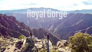
    Download Route

    Save to wishlist, Garmin & download.