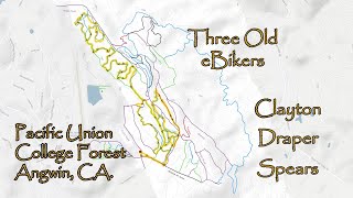
A selection of winding single track trails on the "Front Side" of the forest (keeping you off the more exposed "steep side"). You will do the entirety of the Maze area , as well as some other fine selections. This is a great intermediate ride and leaves room in the tank for more trails if so desired. All mountain bike types will work on this route including hardtails and fat bikes.
For a more advanced ride on the Steep Side, try the Freeride Sampler route
Trail Issues on Route
- Significant Issue / Amber: 2 trails (newest: Apr 19, 2026)
Local Trail Association
Pacific Union CollegeStats
-
Distance8 miles
-
Altitude min1,719 ft
-
Altitude start1,722 ft
-
Altitude end1,726 ft
-
Climb785 ft
-
Descent-781 ft
-
Grade max-22.9%
-
Grade min49.3%
-
Distance climb3 miles
-
Distance down4 miles
-
Distance flat1 mile
3 Reviews & Comments
We hope you've been enjoying Trailforks!
Create a FREE account to view route comments and much more.
Trails in Route
| 3,169 ft | |||||
| 1,083 ft | |||||
| 1,004 ft | |||||
| 869 ft | |||||
| 942 ft | |||||
| 2,776 ft | |||||
| 3,885 ft | |||||
| 1,063 ft | |||||
| 2,562 ft | |||||
| 646 ft | |||||
| 1,184 ft | |||||
| 2,612 ft | |||||
| 2,769 ft | |||||
| 364 ft | |||||
| 968 ft | |||||
| 400 ft |
Details
- Featured
-
Riding area
-
Primary ActivityMountain Bike
-
Other Activities
- E-Bike
-
Difficulty ratingBlue
-
Route TypeLoop
-
eBike Allowed
-
Bike typeAM, XC, Fat
-
Physical ratingModerate
Directions
- Walk northwest on Meadow View Road.
- Continue for 100 meters.
- Walk northwest on Creek Bypass Trail.
- Continue for 60 meters.
- Walk northwest on Creek Bypass Trail.
- Continue for 200 meters.
- Walk northwest on Creek Bypass Trail.
- Continue for 200 meters.
- Walk northwest on Creek Trail.
- Continue for 100 meters.
- Walk north on Easy Does It.
- Continue for 400 meters.
- Walk southeast on ridgeside.
- Continue for 80 meters.
- Walk east on Roller Coaster.
- Continue for 200 meters.
- Walk southwest on Roller Coaster.
- Continue for 100 meters.
- Walk northwest on Creek Trail.
- Continue for 100 meters.
- Walk northwest on Meadow Trail.
- Continue for 200 meters.
- Walk northwest on Meadow Trail.
- Continue for 100 meters.
- Walk northeast on Neapolatin.
- Continue for 10 meters.
- Walk north on Busy Body.
- Continue for 300 meters.
- Walk west on Busy Body.
- Continue for 100 meters.
- Walk southeast on Busy Body.
- Continue for 200 meters.
- Walk south on Busy Body.
- Continue for 100 meters.
- Walk southeast on Ridge Road.
- Continue for 500 meters.
- Walk northwest on ridgeside.
- Continue for 200 meters.
- Walk southeast on Scoobie's.
- Continue for 60 meters.
- Walk south on Scoobie's.
- Continue for 50 meters.
- Walk southwest on Scoobie's.
- Continue for 50 meters.
- Walk west on Scoobie's.
- Continue for 200 meters.
- Walk south on Scoobie's.
- Continue for 90 meters.
- Walk southeast on Creek Trail.
- Continue for 300 meters.
- Walk southeast on Creek Trail.
- Continue for 300 meters.
- Walk north on Saddle road.
- Continue for less than 10 meters.
- Walk southeast on Ridge Road.
- Continue for 70 meters.
- Walk southeast on Ridge Road.
- Continue for 70 meters.
- Walk southeast on Ridge Road.
- Continue for 40 meters.
- Walk north on Mossy Creek.
- Continue for less than 10 meters.
- Walk northeast on Mossy Creek.
- Continue for 50 meters.
- Walk northeast on Cut-Out.
- Continue for 30 meters.
- Walk northeast on Cut-Out.
- Continue for 20 meters.
- Walk east on Cut-Out.
- Continue for 20 meters.
- Walk southeast on Cut-Out.
- Continue for 30 meters.
- Walk east on Cut-Out.
- Continue for 20 meters.
- Walk northeast on Cut-Out.
- Continue for 20 meters.
- Walk south on Mossy Creek.
- Continue for 90 meters.
- Walk south on Mossy Creek.
- Continue for 80 meters.
- Unknown
- Snow Groomed
- Snow Packed
- Snow Covered
- Snow Cover Partial
- Freeze/thaw Cycle
- Icy
- Prevalent Mud
- Wet
- Variable
- Ideal
- Dry
- Very Dry
The colour categories are based on what percentage of riders are riding a trail in its intended direction.
- > 96%
- > 90%
- > 80%
- > 70%
- > 50%
- < 50%
- bi-directional trail
- no data
- < 2 days
- < 1 week
- < 2 weeks
- < 1 month
- < 6 months
- > 6 months
- Downhill Only
- Downhill Primary
- Both Directions
- Uphill Primary
- Uphill Only
- One Direction
- Description
- Photos
- Description & Photos
- Videos
- most popular
- popular
- less popular
- not popular
Service Road Atlas is a free to use, community-driven service for viewing and creating reports on the numerous back-country service roads around B.C. and Alberta.
Save the current map location and zoom level as your default home location whenever this page is loaded.
Save- Singletrack
- Unpaved
Photos
Videos
Recent Trail Reports Along Route
- By Spencer_Young
PUCF & contributors - #56001 - 940 views
