3.1 miles
Distance
431 ft
Climb
-378 ft
Descent
472 ft
High Point
52 ft
Altitude change
246 ft
Altitude min
246 ft
Altitude start
299 ft
Altitude end
0.3%
Grade
-26.5%
Grade max
29.8%
Grade min
2 miles
Distance climb
1 mile
Distance down
2,398 ft
Distance flat

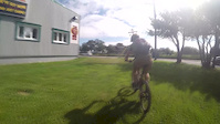
Subnet is 5km loop of intermediate level single track. Its technical and not for beginners. Built by Chris Jerrett of Freeride Mountain Sports, its the most popular trail in the area.

Check out the detailed map on http://www.mtbstjohns.com for more information and photos.

Detailed Description
Subnet is a 3 mile popular intermediate route located near St. John's Newfoundland. This mountain bike only route. This route includes 1 trails. This route climbs 431 ft with a max elevation of 472 ft then descends -378 ft.
Local Trail Association
Local trail association
Avalon Mountain Bike Association (www.ambanl.ca)
Please consider joining or donating to the local riding association to support trail development & maintenance.
Donate to earn trail karma!

Stats

  • Distance
    3 miles
  • Avg time
    53 min 23 sec
  • Altitude change
    52 ft
  • Altitude min
    246 ft
  • Altitude start
    246 ft
  • Altitude end
    299 ft
  • Climb
    431 ft
  • Descent
    -378 ft
  • Grade
    0.3%
  • Grade max
    -26.5%
  • Grade min
    29.8%
  • Distance climb
    2 miles
  • Distance down
    1 mile
  • Distance flat
    2,398 ft

3 Reviews & Comments


We hope you've been enjoying Trailforks!

Create a FREE account to view route comments and much more.

Trails in Route

Details

  • Riding area
  • Primary Activity
    Mountain Bike
  • Difficulty rating
    Blue
  • Ridelogs
    78
no votes yet
close
3D
Trail Conditions
  • Unknown
  • Snow Groomed
  • Snow Packed
  • Snow Covered
  • Snow Cover Partial
  • Freeze/thaw Cycle
  • Icy
  • Prevalent Mud
  • Wet
  • Variable
  • Ideal
  • Dry
  • Very Dry
Trail Flow (Ridden Direction)
Trailforks scans users ridelogs to determine the most popular direction each trail is ridden. A good flowing trail network will have most trails flowing in a single direction according to their intension.
The colour categories are based on what percentage of riders are riding a trail in its intended direction.
  • > 96%
  • > 90%
  • > 80%
  • > 70%
  • > 50%
  • < 50%
  • bi-directional trail
  • no data
Trail Last Ridden
Trailforks scans ridelogs to determine the last time a trail was ridden.
  • < 2 days
  • < 1 week
  • < 2 weeks
  • < 1 month
  • < 6 months
  • > 6 months
Trail Ridden Direction
The intended direction a trail should be ridden.
  • Downhill Only
  • Downhill Primary
  • Both Directions
  • Uphill Primary
  • Uphill Only
  • One Direction
Contribute Details
Colors indicate trail is missing specified detail.
  • Description
  • Photos
  • Description & Photos
  • Videos
Trail Popularity ?
Trailforks scans ridelogs to determine which trails are ridden the most in the last 9 months. Trails are compared with nearby trails in the same city region with a possible 25 colour shades. Think of this as a heatmap, more rides = more kinetic energy = warmer colors.
  • most popular
  • popular
  • less popular
  • not popular
ATV/ORV/OHV Filter
Max Vehicle Width
inches
US Cell Coverage
Legend
cell carrier legend

Radar Time
Activity Recordings
Trailforks uses anonymized public activity data. ?
Activity Recordings
Trailforks uses anonymized public activity data. ?
Personal Heatmap
Activity Types
all / none
Options
2
Date range month
Winter Trails
Warning A routing network for winter maps does not exist. Selecting trails using the winter trails layer has been disabled.
Missing Trails
Most Popular
Least Popular
Trails are colored based on popularity. The more popular a trail is, the more red. Less popular trails trend towards green.
Jump Magnitude Heatmap
Heatmap of where riders jump on trails. Zoom in to see individual jumps, click circles to view jump details.
BC Backroad Status

Service Road Atlas is a free to use, community-driven service for viewing and creating reports on the numerous back-country service roads around B.C. and Alberta.

map legend
Slope Aspect
Direction the slope faces
Flat N NE E SE S SW W NW
Trails Deemphasized
Trails are shown in grey.
disable
Only show trails with no bike usage.
Enable
Suggested Layers
Based on selected activity type

    Save the current map location and zoom level as your default home location whenever this page is loaded.

    Save
    Trail transparency
    • Singletrack
    84
    74
    161
    257
    Subn'edit
    Subn'edit
    2:23 | 1069 | comments: 0 | favs:
    Sep 14, 2015
    Some August Biking

    Recent Trail Reports Along Route

    statustraildateconditiondescription
    Subnet - Outer Loop
    Aug 20, 2025 @ 9:17am
    Aug 20, 2025
    more reports »

    Hit the Trail

    Open in App

    Get this route on your phone instantly.

    Download Route

    Save to wishlist, Garmin & download.