


Open in App
Get this route on your phone instantly.
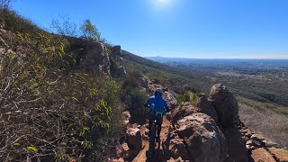
A good route to if you want to do laps on the Switchback downhill trail. Pop this in to your computer to help find all the connectors at the bottom. I've found the figuring the right way to loop a little confusing, so I added this in for route cues.

We hope you've been enjoying Trailforks!
Create a FREE account to view all route reviews and much more.
| 2 miles | |||||
| 1,890 ft |


Service Road Atlas is a free to use, community-driven service for viewing and creating reports on the numerous back-country service roads around B.C. and Alberta.
Save the current map location and zoom level as your default home location whenever this page is loaded.
Save| status | trail | date | condition | description |
|---|---|---|---|---|
May 4, 2026 @ 10:48am (America/Tijuana) May 4, 2026 | ||||
Mar 22, 2025 @ 7:52am Mar 22, 2025 |
 & contributors