



Open in App
Get this route on your phone instantly.
Rainbow road open 7:00 AM on Boxing Day (26 December) and typically remains open through Easter Monday (or late April, depending on seasonal scheduling).
Off season access by enquiry
https://www.rainbowstation.co.nz/get-access
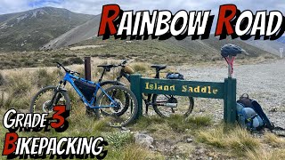
This route combines both the Beautiful forest clad low land valleys of the middle of the top of the South Island, as well as taking in the alpine highlights of the Rainbow road.
It works best in the direction indicated , as its the easiest way to go over the Porika track and it puts the wind predominately at your back when going over the Lewis pass

We hope you've been enjoying Trailforks!
Create a FREE account to view all route reviews and much more.
| 1 | Boat ride( Check timetable) |
| 2 miles | |||||
| 1,010 ft | |||||
| 28 miles | |||||
| 6 miles | |||||
| 8 miles | |||||
| 30 miles | |||||
| 13 miles | |||||
| 1 mile | |||||
| 1 mile |

Service Road Atlas is a free to use, community-driven service for viewing and creating reports on the numerous back-country service roads around B.C. and Alberta.
Save the current map location and zoom level as your default home location whenever this page is loaded.
Save & contributors