20.8 miles
Distance
4,211 ft
Climb
-4,208 ft
Descent
1 mile
High Point

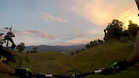
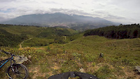
All the climbing is done through unpaved roads. Descent is a singletrack that recently was repaired. Great descent through a coffee plantation.

Detailed Description
Tomatera is a 21 mile moderately popular intermediate route located near Antioquia. This mountain bike only route can be used one direction and has a moderate overall physical rating. This route includes 1 trails. This route climbs 4,211 ft with a max elevation of 7,114 ft then descends -4,208 ft.

Comments


We hope you've been enjoying Trailforks!

Create a FREE account to view route comments and much more.

Trails in Route

Las Mercedes2 miles

Details

  • Riding area
  • Primary Activity
    Mountain Bike
  • Difficulty rating
    Blue
  • Route Type
    Loop
  • Bike type
    AM
  • Direction
    One Direction
  • Physical rating
    Moderate
  • Ridelogs
    3
More Stats for Tomatera mountain bike route
  • Altitude min
    5,194 ft
  • Altitude start
    5,787 ft
  • Altitude end
    5,787 ft
  • Grade max
    -93.9%
  • Grade min
    63.4%
  • Distance climb
    10 miles
  • Distance down
    9 miles
  • Distance flat
    2 miles
no votes yet
close
3D
Trail Conditions
  • Unknown
  • Snow Groomed
  • Snow Packed
  • Snow Covered
  • Snow Cover Partial
  • Freeze/thaw Cycle
  • Icy
  • Prevalent Mud
  • Wet
  • Variable
  • Ideal
  • Dry
  • Very Dry
Trail Flow (Ridden Direction)
Trailforks scans users ridelogs to determine the most popular direction each trail is ridden. A good flowing trail network will have most trails flowing in a single direction according to their intension.
The colour categories are based on what percentage of riders are riding a trail in its intended direction.
  • > 96%
  • > 90%
  • > 80%
  • > 70%
  • > 50%
  • < 50%
  • bi-directional trail
  • no data
Trail Last Ridden
Trailforks scans ridelogs to determine the last time a trail was ridden.
  • < 2 days
  • < 1 week
  • < 2 weeks
  • < 1 month
  • < 6 months
  • > 6 months
Trail Ridden Direction
The intended direction a trail should be ridden.
  • Downhill Only
  • Downhill Primary
  • Both Directions
  • Uphill Primary
  • Uphill Only
  • One Direction
Contribute Details
Colors indicate trail is missing specified detail.
  • Description
  • Photos
  • Description & Photos
  • Videos
Trail Popularity ?
Trailforks scans ridelogs to determine which trails are ridden the most in the last 9 months. Trails are compared with nearby trails in the same city region with a possible 25 colour shades. Think of this as a heatmap, more rides = more kinetic energy = warmer colors.
  • most popular
  • popular
  • less popular
  • not popular
ATV/ORV/OHV Filter
Max Vehicle Width
inches
US Cell Coverage
Legend
cell carrier legend

Radar Time
x Activity Recordings
Trailforks users anonymized public ridelogs from the past 6 months.
  • mountain biking recent
  • mountain biking (>6 month)
  • hiking (1 year)
  • moto (1 year)
Activity Recordings
Trailforks users anonymized public skilogs from the past 12 months.
  • Downhill Ski
  • Backcountry Ski
  • Nordic Ski
  • Snowmobile
Winter Trails
Warning A routing network for winter maps does not exist. Selecting trails using the winter trails layer has been disabled.
x Missing Trails
Most Popular
Least Popular
Trails are colored based on popularity. The more popular a trail is, the more red. Less popular trails trend towards green.
Jump Magnitude Heatmap
Heatmap of where riders jump on trails. Zoom in to see individual jumps, click circles to view jump details.
Trails Deemphasized
Trails are shown in grey.
disable
Only show trails with NO bikes.
enable

Save the current map location and zoom level as your default home location whenever this page is loaded.

Save
Trail transparency
54
121
265
699 | 13 comments
Mercedes atardeciendo
6:28 | 91 | comments: 0 | favs:
Apr 18, 2016
Nos cogio la noche. A final ni se veia.
Ride Las Mercedes - Caldas - Colombia
8:07 | 87 | comments: 0 | favs:
Feb 18, 2015
Downhill - All Mountain - Enduro ride

Recent Trail Reports Along Route

statustraildateconditiondescription
Las Mercedes
Mar 14, 2021 @ 5:22am
Mar 14, 2021
Terreno firme, excelente agarre. Barro únicamente partes cortas de la pista a pesar de la lluvia de días previos. Great grip. Mud in small parts of the trail, even with previous rainy days.
more reports »
  • By mlaracor & contributors
  • #4244 - 843 views