8.6 miles
Distance
2,121 ft
Climb
-2,115 ft
Descent
2 miles
High Point
5 ft
Altitude change
7,294 ft
Altitude min
7,294 ft
Altitude start
7,300 ft
Altitude end
-57.9%
Grade max
48%
Grade min
4 miles
Distance climb
4 miles
Distance down
2,080 ft
Distance flat

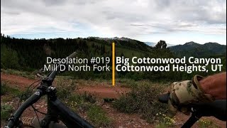
This will ruin your love for Corner Canyon.

Technical climbing, stout but manageable grades, terrific views, fantastic forest rowdy DH and maybe even a moose. Your down side is that hikers love these trails too so keep an eye out for them on the descent. Hop out of the way for DH bikes while climbing (just like you would want them to do for you).

Detailed Description
Triple D is a 9 mile less popular expert route located near Brighton Utah. This mountain bike only route can be used both directions and has a hard overall physical rating. This route includes 3 trails. This route climbs 2,121 ft with a max elevation of 9,253 ft then descends -2,115 ft.

Trail Issues on Route

  • Minor Issue / Yellow: 1 trail (newest: Jul 1, 2025)
Local Trail Association
Please consider joining or donating to the local riding association to support trail development & maintenance.
Donate to earn trail karma!

Stats

  • Distance
    9 miles
  • Altitude min
    7,294 ft
  • Altitude start
    7,294 ft
  • Altitude end
    7,300 ft
  • Climb
    2,121 ft
  • Descent
    -2,115 ft
  • Grade max
    -57.9%
  • Grade min
    48%
  • Distance climb
    4 miles
  • Distance down
    4 miles
  • Distance flat
    2,080 ft

16 Reviews & Comments


We hope you've been enjoying Trailforks!

Create a FREE account to view route comments and much more.

Trails in Route

Details

  • Riding area
  • Primary Activity
    Mountain Bike
  • Difficulty rating
    Black Diamond
  • Route Type
    Out & Back
  • Bike type
    AM
  • Direction
    Both Directions
  • Physical rating
    Hard
no votes yet
close
3D
Trail Conditions
  • Unknown
  • Snow Groomed
  • Snow Packed
  • Snow Covered
  • Snow Cover Partial
  • Freeze/thaw Cycle
  • Icy
  • Prevalent Mud
  • Wet
  • Variable
  • Ideal
  • Dry
  • Very Dry
Trail Flow (Ridden Direction)
Trailforks scans users ridelogs to determine the most popular direction each trail is ridden. A good flowing trail network will have most trails flowing in a single direction according to their intension.
The colour categories are based on what percentage of riders are riding a trail in its intended direction.
  • > 96%
  • > 90%
  • > 80%
  • > 70%
  • > 50%
  • < 50%
  • bi-directional trail
  • no data
Trail Last Ridden
Trailforks scans ridelogs to determine the last time a trail was ridden.
  • < 2 days
  • < 1 week
  • < 2 weeks
  • < 1 month
  • < 6 months
  • > 6 months
Trail Ridden Direction
The intended direction a trail should be ridden.
  • Downhill Only
  • Downhill Primary
  • Both Directions
  • Uphill Primary
  • Uphill Only
  • One Direction
Contribute Details
Colors indicate trail is missing specified detail.
  • Description
  • Photos
  • Description & Photos
  • Videos
Trail Popularity ?
Trailforks scans ridelogs to determine which trails are ridden the most in the last 9 months. Trails are compared with nearby trails in the same city region with a possible 25 colour shades. Think of this as a heatmap, more rides = more kinetic energy = warmer colors.
  • most popular
  • popular
  • less popular
  • not popular
ATV/ORV/OHV Filter
Max Vehicle Width
inches
US Cell Coverage
Legend
cell carrier legend

Radar Time
Activity Recordings
Trailforks uses anonymized public activity data. ?
Activity Recordings
Trailforks uses anonymized public activity data. ?
Personal Heatmap
Activity Types
all / none
Options
2
Date range month
Winter Trails
Warning A routing network for winter maps does not exist. Selecting trails using the winter trails layer has been disabled.
Missing Trails
Most Popular
Least Popular
Trails are colored based on popularity. The more popular a trail is, the more red. Less popular trails trend towards green.
Jump Magnitude Heatmap
Heatmap of where riders jump on trails. Zoom in to see individual jumps, click circles to view jump details.
BC Backroad Status

Service Road Atlas is a free to use, community-driven service for viewing and creating reports on the numerous back-country service roads around B.C. and Alberta.

map legend
Slope Aspect
Direction the slope faces
Flat N NE E SE S SW W NW
Trails Deemphasized
Trails are shown in grey.
disable
Only show trails with no bike usage.
Enable
Suggested Layers
Based on selected activity type

    Save the current map location and zoom level as your default home location whenever this page is loaded.

    Save
    Trail transparency
    • Singletrack
    27
    105
    107
    128
    youtuber Wasatch Crest and Mill D
    Wasatch Crest and Mill D
    10:10 | 312 | comments: 0 | favs:
    Oct 15, 2022

    Recent Trail Reports Along Route

    statustraildateconditiondescription
    Dog Lake to Desolation
    May 24, 2026 @ 8:54pm (America/Denver)
    May 24, 2026
    Mill D North Fork 009
    Jul 23, 2025 @ 8:17am
    Jul 23, 2025
    Dog Lake to Mill D
    Jul 1, 2025 @ 9:10am
    Jul 1, 2025
    No snow. Very large aspen tree down just above jct with Mill D North Fork 009
    more reports »
    • By NSmith11TF Pro & contributors
    • #67314 - 12 views

    Hit the Trail

    Open in App

    Get this route on your phone instantly.

    Download Route

    Save to wishlist, Garmin & download.