3.6 miles
Distance
577 ft
Climb
-602 ft
Descent
1 mile
High Point
-25 ft
Altitude change
5,660 ft
Altitude min
5,696 ft
Altitude start
5,673 ft
Altitude end
-0.1%
Grade
-31.8%
Grade max
28.2%
Grade min
2 miles
Distance climb
2 miles
Distance down
984 ft
Distance flat

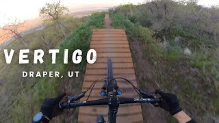
This is a really nice easy spin up, nothing too steep, and a pretty smooth climb. It puts you right at the to of the Vertigo Downhill Only flow trail. If you are coming from the south side of Corner Canyon, you can park right where the Vertigo trail ends. They have removed the barriers on the dead end road. Parking is not great (no turn-around), but you can just park on the side of the dead end road.

The is a really fun and easy loop. You can take it slow, or go enduro and see how fast you can go up and down.

Detailed Description
Vertigo Loop is a highly rated 4 mile popular intermediate route located near Highland UT Utah. This mountain bike only route. This route includes 4 trails. This route climbs 577 ft with a max elevation of 6,220 ft then descends -602 ft.

Stats

  • Distance
    4 miles
  • Avg time
    36 min 14 sec
  • Altitude change
    -25 ft
  • Altitude min
    5,660 ft
  • Altitude start
    5,696 ft
  • Altitude end
    5,673 ft
  • Climb
    577 ft
  • Descent
    -602 ft
  • Grade
    -0.1%
  • Grade max
    -31.8%
  • Grade min
    28.2%
  • Distance climb
    2 miles
  • Distance down
    2 miles
  • Distance flat
    984 ft

48 Reviews & Comments


We hope you've been enjoying Trailforks!

Create a FREE account to view route comments and much more.

Trails in Route

Details

  • Featured
  • Riding area
  • Primary Activity
    Mountain Bike
  • Difficulty rating
    Blue
  • Ridelogs
    698
Avg: 4.85 (7 votes)
close
3D
Trail Conditions
  • Unknown
  • Snow Groomed
  • Snow Packed
  • Snow Covered
  • Snow Cover Partial
  • Freeze/thaw Cycle
  • Icy
  • Prevalent Mud
  • Wet
  • Variable
  • Ideal
  • Dry
  • Very Dry
Trail Flow (Ridden Direction)
Trailforks scans users ridelogs to determine the most popular direction each trail is ridden. A good flowing trail network will have most trails flowing in a single direction according to their intension.
The colour categories are based on what percentage of riders are riding a trail in its intended direction.
  • > 96%
  • > 90%
  • > 80%
  • > 70%
  • > 50%
  • < 50%
  • bi-directional trail
  • no data
Trail Last Ridden
Trailforks scans ridelogs to determine the last time a trail was ridden.
  • < 2 days
  • < 1 week
  • < 2 weeks
  • < 1 month
  • < 6 months
  • > 6 months
Trail Ridden Direction
The intended direction a trail should be ridden.
  • Downhill Only
  • Downhill Primary
  • Both Directions
  • Uphill Primary
  • Uphill Only
  • One Direction
Contribute Details
Colors indicate trail is missing specified detail.
  • Description
  • Photos
  • Description & Photos
  • Videos
Trail Popularity ?
Trailforks scans ridelogs to determine which trails are ridden the most in the last 9 months. Trails are compared with nearby trails in the same city region with a possible 25 colour shades. Think of this as a heatmap, more rides = more kinetic energy = warmer colors.
  • most popular
  • popular
  • less popular
  • not popular
ATV/ORV/OHV Filter
Max Vehicle Width
inches
US Cell Coverage
Legend
cell carrier legend

Radar Time
Activity Recordings
Trailforks uses anonymized public activity data. ?
Activity Recordings
Trailforks uses anonymized public activity data. ?
Personal Heatmap
Activity Types
all / none
Options
2
Date range month
Winter Trails
Warning A routing network for winter maps does not exist. Selecting trails using the winter trails layer has been disabled.
Missing Trails
Most Popular
Least Popular
Trails are colored based on popularity. The more popular a trail is, the more red. Less popular trails trend towards green.
Jump Magnitude Heatmap
Heatmap of where riders jump on trails. Zoom in to see individual jumps, click circles to view jump details.
BC Backroad Status

Service Road Atlas is a free to use, community-driven service for viewing and creating reports on the numerous back-country service roads around B.C. and Alberta.

map legend
Slope Aspect
Direction the slope faces
Flat N NE E SE S SW W NW
Trails Deemphasized
Trails are shown in grey.
disable
Only show trails with no bike usage.
Enable
Suggested Layers
Based on selected activity type

    Save the current map location and zoom level as your default home location whenever this page is loaded.

    Save
    Trail transparency
    158
    375
    1,448
    670
    Vertigo - Draper, UT
    Vertigo - Draper, UT
    trail: Vertigo
    5:02 | 152 | comments: 0 | favs:
    Jul 3, 2025

    Recent Trail Reports Along Route

    statustraildateconditiondescription
    Vertigo
    Jun 2, 2026 @ 4:49pm (America/Denver)
    1 day
    Eagle Crest (West)
    May 14, 2026 @ 5:03pm (America/Boise)
    May 14, 2026
    South Maple Hollow
    May 8, 2026 @ 4:47pm (America/Boise)
    May 8, 2026
    South Maple Hollow Acc
    Apr 11, 2026 @ 5:34pm (America/Boise)
    Apr 11, 2026
    more reports »
    • By toddTF Pro Trailforks & contributors
    • #3000 - 7,923 views

    Hit the Trail

    Open in App

    Get this route on your phone instantly.

    Download Route

    Save to wishlist, Garmin & download.