8.8 miles
Distance
501 ft
Climb
-507 ft
Descent
226 ft
High Point
-5 ft
Altitude change
39 ft
Altitude min
78 ft
Altitude start
72 ft
Altitude end
-26.5%
Grade max
21.4%
Grade min
3 miles
Distance climb
3 miles
Distance down
3 miles
Distance flat

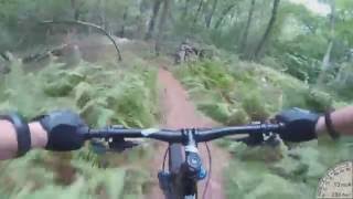
A carefully curated Intermediate ride that is fast, but yet goes up Prospect Hill in a non-technical way, and has no rocks that should require unclipping for.

Detailed Description
Wömpatuck Ring is a 9 mile popular intermediate route located near Hingham Massachusetts. This mountain bike primary route can be used one direction. This route includes 31 trails. This route climbs 501 ft with a max elevation of 226 ft then descends -507 ft.

Trail Issues on Route

  • Closed: 1 trail (newest: Apr 26, 2026)
  • Significant Issue / Amber: 1 trail (newest: Dec 21, 2025)
  • Minor Issue / Yellow: 1 trail (newest: May 14, 2025)
Local Trail Association
Local trail association
Friends of Wompatuck State Park (www.friendsofwompatuck.org)
Please consider joining or donating to the local riding association to support trail development & maintenance.

Stats

  • Distance
    9 miles
  • Avg time
    1 hr 20 min
  • Altitude min
    39 ft
  • Altitude start
    78 ft
  • Altitude end
    72 ft
  • Climb
    501 ft
  • Descent
    -507 ft
  • Grade max
    -26.5%
  • Grade min
    21.4%
  • Distance climb
    3 miles
  • Distance down
    3 miles
  • Distance flat
    3 miles

4 Reviews & Comments


We hope you've been enjoying Trailforks!

Create a FREE account to view route comments and much more.

Route Sections

1 Timed Section
  • 9 miles distance
  • 468 ft climb
  • -479 ft descent
2 Timed Section
  • 9 miles distance
  • 471 ft climb
  • -478 ft descent

Trails in Route

NW2-NW3896 ft
NW2 - NW4367 ft
NW8 - NW9200 ft
Connector217 ft
Freeride Loop 21,079 ft
Freeride Loop 7230 ft
Freeride Ride 1528 ft
Jump Line732 ft
NW - NW11292 ft
NW11 - W41,713 ft
S1-S2607 ft
Pine Run1,549 ft
S4 - S3568 ft
S3-S34174 ft
S34-S101,325 ft
Bird Trail2,257 ft
South Field Trail322 ft
S27 - S281,073 ft
S25-S271,611 ft
S23-S261,529 ft
S23-S161,424 ft
S15-S171,296 ft
W5-W6699 ft
W1 - W2617 ft
NW5 Connector1,591 ft
NW5-NW61,086 ft
NW7 Boundary Line2,215 ft
NW6 - NW7308 ft
Entrance Connector725 ft

Details

  • Riding area
  • Primary Activity
    Mountain Bike
  • Other Activities
    • Hike
    • Trail Running
  • Difficulty rating
    Blue
  • Route Type
    Loop
  • eBike Allowed
  • Direction
    One Direction
  • Ridelogs
    18
Avg: 3.35 (3 votes)
close
3D
Trail Conditions
  • Unknown
  • Snow Groomed
  • Snow Packed
  • Snow Covered
  • Snow Cover Partial
  • Freeze/thaw Cycle
  • Icy
  • Prevalent Mud
  • Wet
  • Variable
  • Ideal
  • Dry
  • Very Dry
Trail Flow (Ridden Direction)
Trailforks scans users ridelogs to determine the most popular direction each trail is ridden. A good flowing trail network will have most trails flowing in a single direction according to their intension.
The colour categories are based on what percentage of riders are riding a trail in its intended direction.
  • > 96%
  • > 90%
  • > 80%
  • > 70%
  • > 50%
  • < 50%
  • bi-directional trail
  • no data
Trail Last Ridden
Trailforks scans ridelogs to determine the last time a trail was ridden.
  • < 2 days
  • < 1 week
  • < 2 weeks
  • < 1 month
  • < 6 months
  • > 6 months
Trail Ridden Direction
The intended direction a trail should be ridden.
  • Downhill Only
  • Downhill Primary
  • Both Directions
  • Uphill Primary
  • Uphill Only
  • One Direction
Contribute Details
Colors indicate trail is missing specified detail.
  • Description
  • Photos
  • Description & Photos
  • Videos
Trail Popularity ?
Trailforks scans ridelogs to determine which trails are ridden the most in the last 9 months. Trails are compared with nearby trails in the same city region with a possible 25 colour shades. Think of this as a heatmap, more rides = more kinetic energy = warmer colors.
  • most popular
  • popular
  • less popular
  • not popular
ATV/ORV/OHV Filter
Max Vehicle Width
inches
US Cell Coverage
Legend
cell carrier legend

Radar Time
Activity Recordings
Trailforks uses anonymized public activity data. ?
Activity Recordings
Trailforks uses anonymized public activity data. ?
Personal Heatmap
Activity Types
all / none
Options
2
Date range month
Winter Trails
Warning A routing network for winter maps does not exist. Selecting trails using the winter trails layer has been disabled.
Missing Trails
Most Popular
Least Popular
Trails are colored based on popularity. The more popular a trail is, the more red. Less popular trails trend towards green.
Jump Magnitude Heatmap
Heatmap of where riders jump on trails. Zoom in to see individual jumps, click circles to view jump details.
BC Backroad Status

Service Road Atlas is a free to use, community-driven service for viewing and creating reports on the numerous back-country service roads around B.C. and Alberta.

map legend
Slope Aspect
Direction the slope faces
Flat N NE E SE S SW W NW
Trails Deemphasized
Trails are shown in grey.
disable
Only show trails with no bike usage.
Enable
Suggested Layers
Based on selected activity type

    Save the current map location and zoom level as your default home location whenever this page is loaded.

    Save
    Trail transparency
    • Singletrack
    • Unpaved
    103
    100
    55
    63
    Wompatuck Pine Run downhill
    Wompatuck Pine Run downhill
    trail: Pine Run
    1610 | comments: 0 | favs:
    Jul 6, 2017

    Recent Trail Reports Along Route

    statustraildateconditiondescription
    NW2-NW3
    Jun 24, 2026 @ 4:52pm (America/New_York)
    1 day
    NW8 - NW9
    Jun 7, 2026 @ 9:08am (America/New_York)
    Jun 7, 2026
    Jump Line
    Apr 26, 2026 @ 3:18pm (America/New_York)
    Apr 26, 2026
    [Admin edit] - All the jumps in this area have been removed due to DCR regulations. Please do not attempt to rebuild.
    NW5 Connector
    Dec 21, 2025 @ 3:51pm (America/New_York)
    Dec 21, 2025
    creek bed is wet and few muddy areas near the bridges
    NW11 - W4
    Dec 21, 2025 @ 3:49pm (America/New_York)
    Dec 21, 2025
    some wet sections
    more reports »
    • By rsilvers & contributors
    • #16159 - 3,029 views

    Hit the Trail

    Open in App

    Get this route on your phone instantly.

    Download Route

    Save to wishlist, Garmin & download.