100 Proof Details
-
Activities
- Mountain Bike
- E-Bike
- Hike
- Trail Running
-
Riding AreaVeterans Park
Lexington, Kentucky -
Difficulty Rating
-
Hiking SAC ScaleT1 Hiking
-
Trail TypeSingletrack
-
Bike TypeDH, AM
-
DirectionDownhill OnlyPopular direction shown
-
Physical RatingModerate
-
Trail VisibilityAlways easy to follow
-
SeasonMay to November
-
Dogs AllowedYes
-
eBike AllowedYes up to Class 1
-
TTFs on TrailDrop, Jump
-
Global Ranking#18744 in Mountain Biking
-
Local Popularity90 in Mountain Biking [+]
- 75 in E-Biking
- 80 in Trail Running
- 90 in Hiking
-
Land Owner
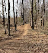
This drink is as smooth as it is strong. Buckle up for 100 Proof, our signature air time line at Veteran's Park. As smooth as Pappies and as fun as Wild Turkey this trail is rockin right from the get go. Drops, s-berms, jumps, rollers everything is designed with fun and progression in mind. With rollable jumps and a wide trail this trail is perfect for folks looking to progress their riding. For more advanced riders, 100 Proof is will give you that sweet air time you crave.
Disclaimer
Always ride in control, look before you leap, and ride at your skill level, there are ride arounds for ALL features! Although bikers are the primary traffic trail, is multi-use. Be aware of your surroundings and watch for uphill traffic.
Local Trail Association
-
Please consider joining or donating to the local trail association to supportdonate to earn trail karma!
trail development & maintenance.
Traditionally Indigenous Territory
More Stats for 100 Proof mountain bike trail trail
-
Altitude change-53 ft
-
Altitude min889 ft
-
Altitude max945 ft
-
Altitude start943 ft
-
Altitude end889 ft
-
Grade-1.2%
-
Grade max-11.5%
-
Grade min7.6%
-
Distance climb620 ft
-
Distance down1,959 ft
-
Distance flat1,821 ft
-
Avg time00:08:14
-
Avg reverse time00:15:46
- view trail stats
- Unknown
- Snow Groomed
- Snow Packed
- Snow Covered
- Snow Cover Partial
- Freeze/thaw Cycle
- Icy
- Prevalent Mud
- Wet
- Variable
- Ideal
- Dry
- Very Dry
The colour categories are based on what percentage of riders are riding a trail in its intended direction.
- > 96%
- > 90%
- > 80%
- > 70%
- > 50%
- < 50%
- bi-directional trail
- no data
- < 2 days
- < 1 week
- < 2 weeks
- < 1 month
- < 6 months
- > 6 months
- Downhill Only
- Downhill Primary
- Both Directions
- Uphill Primary
- Uphill Only
- One Direction
- Description
- Photos
- Description & Photos
- Videos
- most popular
- popular
- less popular
- not popular
- mountain biking recent
- mountain biking (>6 month)
- hiking (1 year)
- moto (1 year)
- Downhill Ski
- Backcountry Ski
- Nordic Ski
- Snowmobile
Save the current map location and zoom level as your default home location whenever this page is loaded.
Save100 Proof Trail Reports
Recent Ridelog Activity on Trail
- 4 rides
- 13.8 km avg distance
- 61 rides
- 12.9 km avg distance
- 480 rides
- Last: Jul 12, 2025
Reviews / Comments
No reviews yet, be the first to write a review or ask a question.
Use trail reports to comment on trail conditions.
We hope you've been enjoying Trailforks!
Create a FREE account to view trail comments and much more.
Nearby Trails
- Up Trail 69 ft
- Doodle Bob 535 ft
- Fine Dining 692 ft
- Connector 896 ft
- Deer Run 2,329 ft
- By jeickelman & contributors
- #356721 - 1,039 views
- follow/subscribe
- login to download gpx or kml files.
You must enter a description before submitting.