more stats
1.5 miles
Distance
10 ft
Climb
-1,605 ft
Descent
00:25:54
Avg time
-1,594 ft
Altitude change
2,638 ft
Altitude min
4,233 ft
Altitude max
4,233 ft
Altitude start
2,638 ft
Altitude end
-20.6%
Grade
-75%
Grade max
10.5%
Grade min
243 ft
Distance climb
1 mile
Distance down
16 ft
Distance flat
00:25:54
Avg time

1199 Details

  • Activities
    • Mountain Bike
  • Riding Area
    Whistler Mountain Bike Park
    Whistler, British Columbia
  • Difficulty Rating
  • Voted Difficulty
    Double Black Diamond (8 votes)
  • Local Popularity
    10 in Mountain Biking
  • Global Ranking
    #40326 in Mountain Biking
  • Trail Type
    Mixed
  • Bike Type
    DH
  • Direction
    Downhill Only
    Popular Direction Shown
  • TTFs on Trail
    Berm, Drop, Jump, Gap Jump, Rock Face, Rock Garden

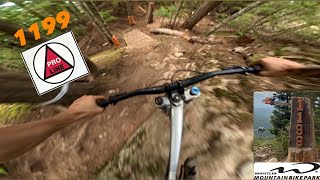
Built to challenge the world's best. This purpose built race track has a bit of everything that the Sea To Sky is known for. Big jumps and drops, steep chutes, rock faces, and rough rooty sections through the old growth.

Bike Park

Recent Activity on Trail

Past Week
  • 0 rides
  •  
6 Months
  • 0 rides
  •  
All
  • 15 rides
  • Last: Sep 6, 2025
c1c2c3c4
January
February
March
April
May
June
July
August
September
October
November
December
update trails status or condition

1199 Trail Reports

Status:
on Oct 18, 2025
Avg: 4.3 (7 votes)
Your vote: 0

view (151)
close
3D
Trail Conditions
  • Unknown
  • Snow Groomed
  • Snow Packed
  • Snow Covered
  • Snow Cover Partial
  • Freeze/thaw Cycle
  • Icy
  • Prevalent Mud
  • Wet
  • Variable
  • Ideal
  • Dry
  • Very Dry
Trail Flow (Ridden Direction)
Trailforks scans users ridelogs to determine the most popular direction each trail is ridden. A good flowing trail network will have most trails flowing in a single direction according to their intension.
The colour categories are based on what percentage of riders are riding a trail in its intended direction.
  • > 96%
  • > 90%
  • > 80%
  • > 70%
  • > 50%
  • < 50%
  • bi-directional trail
  • no data
Trail Last Ridden
Trailforks scans ridelogs to determine the last time a trail was ridden.
  • < 2 days
  • < 1 week
  • < 2 weeks
  • < 1 month
  • < 6 months
  • > 6 months
Trail Ridden Direction
The intended direction a trail should be ridden.
  • Downhill Only
  • Downhill Primary
  • Both Directions
  • Uphill Primary
  • Uphill Only
  • One Direction
Contribute Details
Colors indicate trail is missing specified detail.
  • Description
  • Photos
  • Description & Photos
  • Videos
Trail Popularity ?
Trailforks scans ridelogs to determine which trails are ridden the most in the last 9 months. Trails are compared with nearby trails in the same city region with a possible 25 colour shades. Think of this as a heatmap, more rides = more kinetic energy = warmer colors.
  • most popular
  • popular
  • less popular
  • not popular
ATV/ORV/OHV Filter
Max Vehicle Width
inches
US Cell Coverage
Legend
cell carrier legend

Radar Time
Activity Recordings
Trailforks uses anonymized public activity data. ?
Activity Recordings
Trailforks uses anonymized public activity data. ?
Personal Heatmap
Activity Types
all / none
Options
2
Date range month
Winter Trails
Warning A routing network for winter maps does not exist. Selecting trails using the winter trails layer has been disabled.
Missing Trails
Most Popular
Least Popular
Trails are colored based on popularity. The more popular a trail is, the more red. Less popular trails trend towards green.
Jump Magnitude Heatmap
Heatmap of where riders jump on trails. Zoom in to see individual jumps, click circles to view jump details.
BC Backroad Status

Service Road Atlas is a free to use, community-driven service for viewing and creating reports on the numerous back-country service roads around B.C. and Alberta.

map legend
Slope Aspect
Direction the slope faces
Flat N NE E SE S SW W NW
Trails Deemphasized
Trails are shown in grey.
disable
Only show trails with no bike usage.
Enable
Suggested Layers
Based on selected activity type

    Save the current map location and zoom level as your default home location whenever this page is loaded.

    Save
        Directions to 1199 trailhead (50.086220, -122.964840)

        Photos

        162 more »
        54 |
        Jun 10, 2026 @ 8:35am
        Jun 10, 2026
        208 |
        Aug 6, 2025 @ 9:33pm
        Aug 6, 2025
        154 |
        Apr 10, 2025 @ 4:37pm
        Apr 10, 2025
        202 |
        Dec 20, 2024 @ 8:45am
        Dec 20, 2024

        Videos

        3 more »
        youtuber 1199 | PRO LINE Trail | WHISTLER Bike Park
        4:20 | 677 | Aug 18, 2024 , Whistler
        Crankworx DH Course – 1199 at Whistler is No...
        14:26 | 399 | Jul 15, 2025 , Whistler
        youtuber Most INSANE Moments of 2023! (Pt. 2) - 'The...
        8:34 | 492 | Dec 16, 2023 , Whistler

        Articles

        Know Before You Go: The Definitive Guide To Crankworx Whistler
        Jul 21, 2023 from pinkbike.com
        Everything you need to know ahead of the finale of the Crankworx World Tour.

        6 Reviews & Comments


        We hope you've been enjoying Trailforks!

        Create a FREE account to view trail comments and much more.

        • By o-diggityTF Pro WBP & contributors
        • #626939 - 8,707 views

        Frequently Asked Questions About 1199

        Where is 1199 located?
        1199 is located in Whistler Mountain Bike Park, Whistler, British Columbia, Canada. It is part of the Whistler Mountain Bike Park trail network. The trailhead is located at coordinates 50.08622, -122.96484.
        How hard is 1199?
        1199 is rated as Proline difficulty. The average grade is 20.6%.
        What is the elevation gain for 1199?
        1199 has 10 ft of elevation gain. The trail has 1,605 ft of elevation descent. The elevation ranges from 2,638 ft to 4,233 ft.
        Is 1199 a point to point trail?
        Yes, 1199 is a point to point trail. The direction is Downhill Only. The trail type is mixed.

        Hit the Trail

        Open in App

        Get this trail on your phone instantly.
        open trail in app

        Download Trail

        Save to wishlist, Garmin & download.
        save the trail

        Find Related Routes

        Find routes and users activities that include this trail.
        find routes for this trail

        You must enter a description before submitting.