more stats
449 ft
Distance
-25 ft
Descent
00:01:57
Avg time
-25 ft
Altitude change
423 ft
Altitude min
448 ft
Altitude max
448 ft
Altitude start
423 ft
Altitude end
-5.5%
Grade
-11.5%
Grade max
410 ft
Distance down
00:01:57
Avg time

12 Step Details

  • Activities
    • Mountain Bike
    • E-Bike
  • Riding Area
    Duthie Hill Mountain Bike Park
    Issaquah, Washington
  • Difficulty Rating
  • Voted Difficulty
    Double Black Diamond (7 votes)
  • Local Popularity
    95 in Mountain Biking [+]
    • 95 in E-Biking
  • Global Ranking
    #29825 in Mountain Biking [+]
    • #15336 in E-Biking
  • Trail Type
    Singletrack
  • Bike Type
    DJ
  • Direction
    Downhill Only
  • Physical Rating
    Moderate
  • Season
    All Year
  • Dogs Allowed
    Yes
  • eBike Allowed
  • TTFs on Trail
    Berm, Jump, Gap Jump

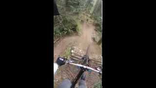
Quick series of 10 (not 12, despite the name) gap jumps. Gaps consist of kickers (steep lips) and hips.

Access Info

Entrance branches off from the Rehab trail. Stay to the left when you come to a fork in the trail.

Local Trail Association
Traditionally Indigenous Territory

Recent Activity on Trail

Past Week
  • 26 rides
  • 13 miles average
6 Months
  • 416 rides
  • 10 miles avg distance
All
  • 3,830 rides
  • Last: Jun 27, 2026
c1c2c3c4
January
February
March
April
May
June
July
August
September
October
November
December
update trails status or condition

12 Step Trail Reports

statusdatedescription
Dec 21, 2025 @ 8:59am (America/Los_Angeles)
Dec 21, 2025
Duthie Hill Park - OPEN! Thank you King County Parks & Evergreen Mountain Bike Alliance & Volunteers!
Dec 18, 2025 @ 3:46pm (America/Los_Angeles)
Dec 18, 2025
Trail Update: Duthie Hill Trails remain CLOSED. ETA: Targeting a reopening before Christmas. Thanks Parks & EMBA!
Dec 12, 2025 @ 12:52pm (America/Los_Angeles)
Dec 12, 2025
*** Duthie Hill Park CLOSED *** - Storm Damage
Nov 23, 2024 @ 12:03pm
Nov 23, 2024
Nov 20, 2024 @ 11:25am
Nov 20, 2024
King County Parks has closed Duthie Hill due to downed trees and damage. Please avoid Duthie and respect the closure. Anticipated reopening,...
more »
Status:
on Dec 21, 2025
Wet
Avg: 4.18 (16 votes)
Your vote: 0

view (48,077)
close
3D
Trail Conditions
  • Unknown
  • Snow Groomed
  • Snow Packed
  • Snow Covered
  • Snow Cover Partial
  • Freeze/thaw Cycle
  • Icy
  • Prevalent Mud
  • Wet
  • Variable
  • Ideal
  • Dry
  • Very Dry
Trail Flow (Ridden Direction)
Trailforks scans users ridelogs to determine the most popular direction each trail is ridden. A good flowing trail network will have most trails flowing in a single direction according to their intension.
The colour categories are based on what percentage of riders are riding a trail in its intended direction.
  • > 96%
  • > 90%
  • > 80%
  • > 70%
  • > 50%
  • < 50%
  • bi-directional trail
  • no data
Trail Last Ridden
Trailforks scans ridelogs to determine the last time a trail was ridden.
  • < 2 days
  • < 1 week
  • < 2 weeks
  • < 1 month
  • < 6 months
  • > 6 months
Trail Ridden Direction
The intended direction a trail should be ridden.
  • Downhill Only
  • Downhill Primary
  • Both Directions
  • Uphill Primary
  • Uphill Only
  • One Direction
Contribute Details
Colors indicate trail is missing specified detail.
  • Description
  • Photos
  • Description & Photos
  • Videos
Trail Popularity ?
Trailforks scans ridelogs to determine which trails are ridden the most in the last 9 months. Trails are compared with nearby trails in the same city region with a possible 25 colour shades. Think of this as a heatmap, more rides = more kinetic energy = warmer colors.
  • most popular
  • popular
  • less popular
  • not popular
ATV/ORV/OHV Filter
Max Vehicle Width
inches
US Cell Coverage
Legend
cell carrier legend

Radar Time
Activity Recordings
Trailforks uses anonymized public activity data. ?
Activity Recordings
Trailforks uses anonymized public activity data. ?
Personal Heatmap
Activity Types
all / none
Options
2
Date range month
Winter Trails
Warning A routing network for winter maps does not exist. Selecting trails using the winter trails layer has been disabled.
Missing Trails
Most Popular
Least Popular
Trails are colored based on popularity. The more popular a trail is, the more red. Less popular trails trend towards green.
Jump Magnitude Heatmap
Heatmap of where riders jump on trails. Zoom in to see individual jumps, click circles to view jump details.
BC Backroad Status

Service Road Atlas is a free to use, community-driven service for viewing and creating reports on the numerous back-country service roads around B.C. and Alberta.

map legend
Slope Aspect
Direction the slope faces
Flat N NE E SE S SW W NW
Trails Deemphasized
Trails are shown in grey.
disable
Only show trails with no bike usage.
Enable
Suggested Layers
Based on selected activity type

    Save the current map location and zoom level as your default home location whenever this page is loaded.

    Save
        Directions to 12-step trailhead (47.577440, -121.980760)

        Photos

        1 more »
        135 |
        Oct 30, 2021 @ 6:58pm
        Oct 30, 2021

        Videos

        19 more »
        12 Step - Duthie Hill MTB Park [4K]
        0:31 | 969 | May 15, 2022 , Issaquah
        12 Step // Duthie Mountain Bike Park //...
        0:46 | 1532 | Dec 28, 2019 , Issaquah
        12 steps on a downhill bike
        1134 | Oct 17, 2015 , Issaquah
        Carters Edit
        0:22 | 205 | Oct 28, 2018 , Issaquah

        4 Reviews & Comments


        We hope you've been enjoying Trailforks!

        Create a FREE account to view trail comments and much more.

        • By greencowmanTF Pro & contributors
        • #33627 - 8,393 views

        Frequently Asked Questions About 12 Step

        Where is 12 Step located?
        12 Step is located in Duthie Hill Mountain Bike Park, Issaquah, Washington, United States. It is part of the Duthie Hill Mountain Bike Park trail network. The trailhead is located at coordinates 47.57744, -121.98076.
        How hard is 12 Step?
        12 Step is rated as Double Black Diamond difficulty. The physical rating is Moderate. The average grade is 5.5%.
        What is the elevation gain for 12 Step?
        The trail has 25 ft of elevation descent. The elevation ranges from 423 ft to 448 ft.
        Is 12 Step a point to point trail?
        Yes, 12 Step is a point to point trail. The direction is Downhill Only. The trail type is singletrack.

        Hit the Trail

        Open in App

        Get this trail on your phone instantly.
        open trail in app

        Download Trail

        Save to wishlist, Garmin & download.
        save the trail

        Find Related Routes

        Find routes and users activities that include this trail.
        find routes for this trail

        You must enter a description before submitting.