
more stats
1.6 miles
Distance
-1,510 ft
Descent
00:15:40
Avg time
-1,511 ft
Altitude change
1,852 ft
Altitude min
3,363 ft
Altitude max
3,363 ft
Altitude start
1,854 ft
Altitude end
-18.5%
Grade
-65.7%
Grade max
-0.3%
Grade min
2 miles
Distance down
00:15:40
Avg time

352 Details

  • Activities
    • Mountain Bike
    • E-Bike
    • Gravel Bike
  • Riding Area
  • Ref Number
    #352
  • Difficulty Rating
  • Local Popularity
    100 in Mountain Biking [+]
    • 100 in E-Biking
    • 5 in Gravel Biking
  • Global Ranking
    #25522 in Mountain Biking [+]
    • #3082 in E-Biking
    • #14697 in Gravel Biking
  • National Ranking
    #2,467 in Mountain Biking · Italy [+]
    • #390 in E-Biking
    • #1,331 in Gravel Biking
  • Trail Type
    Doubletrack
  • Bike Type
    DH, AM, Gravel
  • Direction
    Downhill Only
    Popular Direction Shown
  • Trail Visibility
    Always easy to follow
  • Dogs Allowed
    Yes
  • eBike Allowed
    Yes up to Class 1
  • TTFs on Trail
    Drop, Jump

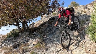
Senza ombra di dubbio il più saltoso, spondoso, divertente delle Valli di Lanzo..
da evitare in caso di fango

Tags
DropsJumps

Recent Activity on Trail

Past Week
  • 1 rides
  • 24 miles average
6 Months
  • 18 rides
  • 14 miles avg distance
All
  • 90 rides
  • Last: Oct 17, 2026
c1c2c3c4
January
February
March
April
May
June
July
August
September
October
November
December
update trails status or condition

352 Trail Reports

statusdatedescription
Oct 4, 2026 @ 10:21am (Europe/Rome)
Oct 4, 2026
Pulito ma molto secco. Ultimi tornanti asciutti
Oct 1, 2026 @ 5:10pm (Europe/Rome)
Oct 1, 2026
Appena soffiato è Decespugliato 👌
Apr 5, 2026 @ 3:32pm (Europe/Rome)
Apr 5, 2026
Condizioni top, ultimi tornanti asciutti
Mar 7, 2026 @ 10:27am (Europe/Rome)
Mar 7, 2026
Pulito e ben tenuto. Gli ultimi 3 tornanti in contro pendenza, ripidi stretti e fangosi sono l'unica nota stonata.
Feb 28, 2026 @ 8:31pm (Europe/Rome)
Feb 28, 2026
Terreno Perfetto, Trail appena soffiato ✅👌
more »
Status:
on Oct 4, 2026
Dry
Avg: 4.37 (10 votes)
Your vote: 0

view (1,385)
close
      Directions to 352 trailhead (45.289030, 7.440140)

      Photos

      5 more »
      mtb
      352
      58 |
      Feb 23, 2026 @ 5:07am
      Feb 23, 2026
      mtb
      352
      50 |
      Feb 23, 2026 @ 5:06am
      Feb 23, 2026
      report
      mtb
      352
      47 |
      Feb 28, 2026 @ 11:31am
      Feb 28, 2026
      report
      mtb
      352
      44 |
      Dec 31, 2025 @ 6:59am
      Dec 31, 2025

      Videos

      2 more »
      MTB - Punta Serena, 1160 m + sentiero 352
      mtb
      4:55 | 77 | Nov 1, 2025 , Lanzo Torinese
      Rifugio Salvin e 352, trails da duri nelle...
      mtb
      9:42 | 250 | Sep 21, 2022 , Lanzo Torinese
      4.6 ★★★★★
      10 Ratings
      5 ★ 70%
      4 ★ 20%
      3 ★ 10%
      2 ★
      1 ★

      3 Reviews & Comments

      robertoc6dMhE
      salti, sponde, molto bello, scorrevole e pulito
      lexmex
      great and various biketrail (no hiking). Not too difficult and fast.
      dave-82
      Trail mooolto bello! ..parte quasi "nature" per più diventare sempre più ricco di sponde, salti, drop per poi chiudere con un paio di ripidi!

      We hope you've been enjoying Trailforks!

      Create a FREE account to view all trail reviews and much more.

      • By Steu84 & contributors
      • #175641 - 4,152 views

      Frequently Asked Questions

      ▼ Where is 352 located?
      352 is located in Lanzo Torinese, Italy. It is part of the Lanzo Torinese trail network. The trailhead is located at coordinates 45.28903, 7.44014.
      ▼ How hard is 352?
      352 is rated as Red difficulty. The average grade is 18.5%.
      ▼ What is the elevation gain for 352?
      The trail has 1,510 ft of elevation descent. The elevation ranges from 1,852 ft to 3,363 ft.
      ▼ Is 352 a point to point trail?
      Yes, 352 is a point to point trail. The direction is Downhill Only. The trail type is doubletrack.
      ▼ How long is 352?
      352 is 1.6 miles long. The trail type is doubletrack.
      ▼ Are dogs allowed on 352?
      Yes, dogs are allowed on 352. Please keep dogs on a leash where required and clean up after them.
      ▼ How long does it take to ride 352?
      Based on recorded activities, it takes an average of 16 minutes to ride 352. The trail is 1.6 miles long. Actual times will vary based on fitness level, conditions, and pace. View recent activity logs for more details.
      ▼ How busy is 352?
      352 is a very popular trail. There have been 1,275 recorded activities on this trail. The trail has received 1,385 check-ins. View recent activity on this trail.

      Hit the Trail

      Open in App

      Get this trail on your phone instantly.

      open trail in app

      Download Trail

      Save to wishlist, Garmin & download.
      save the trail

      Find Related Routes

      Find routes and users activities that include this trail.
      find routes for this trail

      You must enter a description before submitting.

