2.1 miles
Distance
44 ft
Climb
-1,150 ft
Descent
00:21:53
Avg time
3K Details
-
Activities
- Mountain Bike
- E-Bike
- Hike
- Trail Running
-
Riding AreaComuna de Bunyola
Bunyola -
Difficulty Rating
-
Voted DifficultyBlue (1 vote)
-
Trail TypeSingletrack
-
Bike TypeDH, AM
-
DirectionDownhill PrimaryPopular direction shown
-
Climb DifficultyBlack Diamond
-
Physical RatingExtreme
-
Dogs AllowedYes
-
eBike AllowedYes up to Class 1
-
Global Ranking#52309 in Mountain Biking
-
Local Popularity30 in Mountain Biking [+]
- 5 in E-Biking
- 5 in Trail Running
- 95 in Hiking
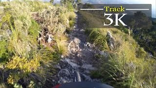
3km of non stop rock garden, a true test of endurance for both the rider and the bike. DH tires recommended, if not, you will certainly have several punctures due to the endless number of rocks ready to destroy you tires, wheels and arms.
More Stats for 3K multi-use trail trail
-
Altitude change-1,108 ft
-
Altitude min959 ft
-
Altitude max2,069 ft
-
Altitude start2,067 ft
-
Altitude end958 ft
-
Grade-9.8%
-
Grade max-61.3%
-
Grade min14.5%
-
Distance climb1,250 ft
-
Distance down2 miles
-
Distance flat784 ft
-
Avg time00:21:53
- view trail stats
close
3D
Trail Conditions
- Unknown
- Snow Groomed
- Snow Packed
- Snow Covered
- Snow Cover Partial
- Freeze/thaw Cycle
- Icy
- Prevalent Mud
- Wet
- Variable
- Ideal
- Dry
- Very Dry
Trail Flow (Ridden Direction)
Trailforks scans users ridelogs to determine the most popular direction each trail is ridden. A good flowing trail network will have most trails flowing in a single direction according to their intension.
The colour categories are based on what percentage of riders are riding a trail in its intended direction.
- > 96%
- > 90%
- > 80%
- > 70%
- > 50%
- < 50%
- bi-directional trail
- no data
Trail Last Ridden
Trailforks scans ridelogs to determine the last time a trail was ridden.
- < 2 days
- < 1 week
- < 2 weeks
- < 1 month
- < 6 months
- > 6 months
Trail Ridden Direction
The intended direction a trail should be ridden.
- Downhill Only
- Downhill Primary
- Both Directions
- Uphill Primary
- Uphill Only
- One Direction
Contribute Details
Colors indicate trail is missing specified detail.
- Description
- Photos
- Description & Photos
- Videos
Trail Popularity ?
Trailforks scans ridelogs to determine which trails are ridden the most in the last 9 months.
Trails are compared with nearby trails in the same city region with a possible 25 colour shades.
Think of this as a heatmap, more rides = more kinetic energy = warmer colors.
- most popular
- popular
- less popular
- not popular
ATV/ORV/OHV Filter
Max Vehicle Width
inches
US Cell Coverage
Legend
Radar Time
x
Activity Recordings
Trailforks users anonymized public ridelogs from the past 6 months.
- mountain biking recent
- mountain biking (>6 month)
- hiking (1 year)
- moto (1 year)
Activity Recordings
Trailforks users anonymized public skilogs from the past 12 months.
- Downhill Ski
- Backcountry Ski
- Nordic Ski
- Snowmobile
Winter Trails
Warning
A routing network for winter maps does not exist. Selecting trails using the winter trails layer has been disabled.
x
Missing Trails
Most Popular
Least Popular
Trails are colored based on popularity. The more popular a trail is, the more red. Less popular trails trend towards green.
Jump Magnitude Heatmap
Heatmap of where riders jump on trails. Zoom in to see individual jumps, click circles to view jump details.
Trails Deemphasized
Trails are shown in grey.
Only show trails with NO bikes.
Save the current map location and zoom level as your default home location whenever this page is loaded.
Save
Directions to 3k trailhead
(39.704820, 2.727330)
update trails status or condition
3K Trail Reports
view all reports »
Recent Ridelog Activity on Trail
Past Week
- 0 rides
6 Months
- 0 rides
All
- 5 rides
- Last: May 18, 2025
We hope you've been enjoying Trailforks!
Create a FREE account to view trail comments and much more.
Nearby Trails
- Camino Principal Comuna Bunyola 0 ft
- Cas Bergandet Parte Alta 1,568 ft
- Coma D'en Buscante 1,909 ft
- Access Penyal De Honor 2,966 ft
- Bosque Encantado (coma De S'aigo, Salida Pista) 3,271 ft
- By elyari
TRAILFORKS TFSPAIN & contributors
- #67035 - 1,386 views
- follow/subscribe
- login to download gpx or kml files.
You must enter a description before submitting.