more stats
2,073 ft
Distance
-72 ft
Descent
00:02:29
Avg time
-72 ft
Altitude change
237 ft
Altitude min
309 ft
Altitude max
309 ft
Altitude start
236 ft
Altitude end
-3.5%
Grade
-11.7%
Grade max
-1.2%
Grade min
2,073 ft
Distance down
00:02:29
Avg time

Ahaa! Details

  • Activities
    • Hike
    • Trail Running
  • Riding Area
    Bertembos
    Leuven
  • Difficulty Rating
  • Local Popularity
    5 in Hiking [+]
    • 95 in Trail Running
  • Global Ranking
    #128222 in Hiking [+]
    • #35071 in Trail Running
  • Hiking SAC Scale
    T1 Hiking
  • Trail Type
    Singletrack
  • Direction
    Both Directions
  • Physical Rating
    Moderate
  • Dogs Allowed
    Yes
  • eBike Allowed

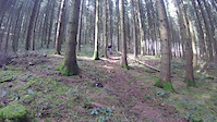
A flat sprint till the first 90° left hander. Then a long flat sprint till you drop in the technical part. First a small tree that you can jump, then a large tree you can roll or chicken (on the left). You ride shortly on a small ridge to drop right into long wide turns. The final part of the trail gets steeper and can be slippery when wet.

Disclaimer

Biking not allowed

Recent Activity on Trail

Past Week
  • 0 rides
  •  
6 Months
  • 0 rides
  •  
All
  • 0 rides
  •  
c1c2c3c4
January
February
March
April
May
June
July
August
September
October
November
December
update trails status or condition

Ahaa! Trail Reports

statusdatedescription
May 1, 2021 @ 8:42am
May 1, 2021
more »
Status:
on May 1, 2021
Dry
Avg: 3.5 (2 votes)
Your vote: 0

view (486)
close
3D
Trail Conditions
  • Unknown
  • Snow Groomed
  • Snow Packed
  • Snow Covered
  • Snow Cover Partial
  • Freeze/thaw Cycle
  • Icy
  • Prevalent Mud
  • Wet
  • Variable
  • Ideal
  • Dry
  • Very Dry
Trail Flow (Ridden Direction)
Trailforks scans users ridelogs to determine the most popular direction each trail is ridden. A good flowing trail network will have most trails flowing in a single direction according to their intension.
The colour categories are based on what percentage of riders are riding a trail in its intended direction.
  • > 96%
  • > 90%
  • > 80%
  • > 70%
  • > 50%
  • < 50%
  • bi-directional trail
  • no data
Trail Last Ridden
Trailforks scans ridelogs to determine the last time a trail was ridden.
  • < 2 days
  • < 1 week
  • < 2 weeks
  • < 1 month
  • < 6 months
  • > 6 months
Trail Ridden Direction
The intended direction a trail should be ridden.
  • Downhill Only
  • Downhill Primary
  • Both Directions
  • Uphill Primary
  • Uphill Only
  • One Direction
Contribute Details
Colors indicate trail is missing specified detail.
  • Description
  • Photos
  • Description & Photos
  • Videos
Trail Popularity ?
Trailforks scans ridelogs to determine which trails are ridden the most in the last 9 months. Trails are compared with nearby trails in the same city region with a possible 25 colour shades. Think of this as a heatmap, more rides = more kinetic energy = warmer colors.
  • most popular
  • popular
  • less popular
  • not popular
ATV/ORV/OHV Filter
Max Vehicle Width
inches
US Cell Coverage
Legend
cell carrier legend

Radar Time
Activity Recordings
Trailforks uses anonymized public activity data. ?
Activity Recordings
Trailforks uses anonymized public activity data. ?
Personal Heatmap
Activity Types
all / none
Options
2
Date range month
Winter Trails
Warning A routing network for winter maps does not exist. Selecting trails using the winter trails layer has been disabled.
Missing Trails
Most Popular
Least Popular
Trails are colored based on popularity. The more popular a trail is, the more red. Less popular trails trend towards green.
Jump Magnitude Heatmap
Heatmap of where riders jump on trails. Zoom in to see individual jumps, click circles to view jump details.
BC Backroad Status

Service Road Atlas is a free to use, community-driven service for viewing and creating reports on the numerous back-country service roads around B.C. and Alberta.

map legend
Slope Aspect
Direction the slope faces
Flat N NE E SE S SW W NW
Trails Deemphasized
Trails are shown in grey.
disable
Only show trails with no bike usage.
Enable
Suggested Layers
Based on selected activity type

    Save the current map location and zoom level as your default home location whenever this page is loaded.

    Save
        Directions to ahaa trailhead (50.881070, 4.639280)

        Photos

        1 more »
        253 |
        Feb 29, 2004 @ 7:43pm
        Feb 29, 2004

        Videos

        2 more »
        Savage clip
        0:12 | 276 | Apr 6, 2016 , Leuven
        spider caught in the act
        0:05 | 398 | Sep 27, 2010 , Leuven

        Routes with this trail

        12 miles 937 ft 9 Loop
        The best route to ride all trails in Bertembos. It also includes the Akka trails in the small Kinderenbos....
        42 miles 1,868 ft 54 Loop
        Kortenberg to Holsberg all trails

        Reviews / Comments

        No reviews yet, be the first to write a review or ask a question.
        Use trail reports to comment on trail conditions.


        We hope you've been enjoying Trailforks!

        Create a FREE account to view trail comments and much more.

        • By gonzo-phTF Pro & contributors
        • #234168 - 534 views

        Frequently Asked Questions About Ahaa!

        Where is Ahaa! located?
        Ahaa! is located in Bertembos, Leuven, Belgium. It is part of the Bertembos trail network. The trailhead is located at coordinates 50.88107, 4.63928.
        How hard is Ahaa!?
        Ahaa! is rated as Blue difficulty. The physical rating is Moderate. The average grade is 3.5%.
        What is the elevation gain for Ahaa!?
        The trail has 72 ft of elevation descent. The elevation ranges from 237 ft to 309 ft.
        Is Ahaa! a point to point trail?
        Ahaa! is not a point to point trail. The direction is Both Directions. The trail type is singletrack.

        Hit the Trail

        Open in App

        Get this trail on your phone instantly.
        open trail in app

        Download Trail

        Save to wishlist, Garmin & download.
        save the trail

        Find Related Routes

        Find routes and users activities that include this trail.
        find routes for this trail

        You must enter a description before submitting.