more stats
2,881 ft
Distance
121 ft
Climb
-35 ft
Descent
00:09:48
Avg time
86 ft
Altitude change
737 ft
Altitude min
857 ft
Altitude max
737 ft
Altitude start
823 ft
Altitude end
2.972%
Grade
-10.622%
Grade max
18.224%
Grade min
1,769 ft
Distance climb
767 ft
Distance down
346 ft
Distance flat
00:09:48
Avg time

Ale Trail Details

  • Activities
    • Mountain Bike
    • E-Bike
    • Hike
    • Trail Running
  • Riding Area
    Roundtopia
    Round Top, New York
  • Difficulty Rating
  • Voted Difficulty
    Blue (1 vote)
  • Local Popularity
    40 in Mountain Biking heatmap [+]
    • 45 in E-Biking
    • 5 in Trail Running
    • 5 in Hiking
  • Global Ranking
    #107123 in Mountain Biking [+]
    • #70699 in E-Biking
    • #307092 in Trail Running
    • #298501 in Hiking
  • State Ranking
    #1,594 in Mountain Biking · New York State [+]
    • #261 in E-Biking
    • #5,443 in Trail Running
    • #6,154 in Hiking
  • Trail Type
    Singletrack
  • Bike Type
    XC
  • Direction
    Both Directions
  • Climb Difficulty
    Blue
  • Physical Rating
    Moderate
  • Trail Visibility
    Always easy to follow
  • Dogs Allowed
    Yes
  • eBike Allowed
    Yes up to Class 1
  • TTFs on Trail
    Rock Face
  • Land Owner
    Round Top Mountain Bike Association

The Ale Trail is a popular trail for bikes and hikers, so use caution when riding it, particularly downhill (Mountain Brauhouse to Riedlbauer’s). The trail has many smaller natural rock rams to jump off of and have some fun. There are also two steeper rocky sections that will challenge beginners and give advanced riders a chance to have some fun and maybe test their skill at taking these faster. Uphill the two rock sections are a good test of your technical climbing.

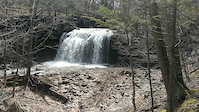
This is also a nice spot to take it slow and admire the creek and its rocky features. At the large rock downhill/climb there is a waterfall. Its a nice spot to take a break and get a few photos.

Access Info

Riedlbauer’s: Drive/Ride through the parking lot until you get to a gravel area with a dumpster. Park here (if driving) and the trail takes a short dip down to the creek and across the wooden bridge.

Mountain Brauhouse: From the parking area, go to the street and left. The trail will begin about 50' ahead on your left just past the intersection with Winter Clove.

Tags
BridgesRock slabsRockyWaterfall

Trail Supporters

  • RTMBA
    Maintainer

Local Trail Association

Traditionally Indigenous Territory

Recent Activity on Trail

Past Week
  • 0 rides
  •  
6 Months
  • 3 rides
  • 14 miles avg distance
All
  • 118 rides
  • Last: Aug 22, 2026
c1c2c3c4
January
February
March
April
May
June
July
August
September
October
November
December
update trails status or condition

Ale Trail Trail Reports

statusdatedescription
Aug 20, 2023 @ 3:00am
Aug 20, 2023
Aug 11, 2023 @ 12:47pm
Aug 11, 2023
land owner has closed the trail
Oct 11, 2021 @ 7:22am
Oct 11, 2021
Jul 4, 2021 @ 6:35am
Jul 4, 2021
Nov 28, 2020 @ 4:35pm
Nov 28, 2020
Rocky, fun ride along the falls/stream with nice views along the way.
more »
Status:
on Aug 20, 2023
Avg: 4.07 (7 votes)
Your vote: 0

view (1,169)
close
      Directions to ale-trail trailhead (42.251981, -74.024892)

      Photos

      12 more »
      mtb
      239 |
      Nov 10, 2021 @ 5:04pm
      Nov 10, 2021
      mtb
      282 |
      Apr 21, 2020 @ 10:49am
      Apr 21, 2020
      report
      mtb
      148 |
      Nov 28, 2020 @ 4:36pm
      Nov 28, 2020
      report
      mtb
      124 |
      Nov 28, 2020 @ 4:36pm
      Nov 28, 2020

      Videos

      1 more »
      Ale Trail Waterfall
      mtb
      0:04 | 186 | Apr 21, 2020 , Round Top

      Routes with this trail

      more »
      7 miles • 752 ft • 11 • Out & Back •
      This is a fairly easy course for a beginner to learn on. There are a few tough hills(the Quarry) (Hematoma...
      11 miles • 1,352 ft • 20 •
      2017 RTMBA Enduro Course. 11 miles 6 timed stages
      5 miles • 470 ft • 11 • Loop • Race •
      2017 Round Top rally XC race course. Pro Cat 1 and Cat 2 lap.
      4.2 ★★★★★
      7 Ratings
      5 ★ 57%
      4 ★ 14%
      3 ★ 14%
      2 ★ 14%
      1 ★

      1 Review & Comments


      We hope you've been enjoying Trailforks!

      Create a FREE account to view all trail reviews and much more.

      • By rtnyriderTF Pro RTMBA & contributors
      • #23499 - 2,972 views

      Frequently Asked Questions

      ▼ Where is Ale Trail located?
      Ale Trail is located in Roundtopia, Round Top, New York, United States. It is part of the Roundtopia trail network. The trailhead is located at coordinates 42.25198, -74.02489.
      ▼ How hard is Ale Trail?
      Ale Trail is rated as Blue difficulty. The physical rating is Moderate. The average grade is 2.972%. The climb difficulty is rated Blue.
      ▼ What is the elevation gain for Ale Trail?
      Ale Trail has 121 ft of elevation gain. The trail has 35 ft of elevation descent. The elevation ranges from 737 ft to 857 ft.
      ▼ Is Ale Trail a point to point trail?
      Ale Trail is not a point to point trail. The direction is Both Directions. The trail type is singletrack.
      ▼ How long is Ale Trail?
      Ale Trail is 2,881 ft long. The trail type is singletrack.
      ▼ Are dogs allowed on Ale Trail?
      Yes, dogs are allowed on Ale Trail. Please keep dogs on a leash where required and clean up after them.
      ▼ When is the best time of year to ride Ale Trail?
      Based on activity log data, the most popular months to ride Ale Trail are:
      • June (4 activities)
      • October (2 activities)
      • April (1 activities)
      Check the reports page for current trail conditions.
      ▼ How do I access Ale Trail? Where is the closest parking trailhead?
      The closest parking and trailhead locations to Ale Trail are: View all parking locations in the area.
      ▼ How long does it take to ride Ale Trail?
      Based on recorded activities, it takes an average of 10 minutes to ride Ale Trail. The trail is 2,881 ft long. Actual times will vary based on fitness level, conditions, and pace. View recent activity logs for more details.
      ▼ How busy is Ale Trail?
      Ale Trail is a moderately popular trail. There have been 966 recorded activities on this trail. The trail has received 1,169 check-ins. View recent activity on this trail.

      Hit the Trail

      Open in App

      Get this trail on your phone instantly.

      open trail in app

      Download Trail

      Save to wishlist, Garmin & download.
      save the trail

      Find Related Routes

      Find routes and users activities that include this trail.
      find routes for this trail

      You must enter a description before submitting.