2,313 ft
Distance
24 ft
Climb
-263 ft
Descent
00:02:45
Avg time
Supporters, Builders, Maintainers & Land Managers of AndiU Trail

AndiU Details

  • Activities
    • Mountain Bike
    • E-Bike
  • Riding Area
    Trailarea Göttweig
    Furth bei Göttweig
  • Ref Number
    C4
  • Difficulty Rating
  • Trail Type
    Singletrack
  • Bike Type
    DH, AM, XC
  • Direction
    Downhill Only
    Popular direction shown
  • Trail Visibility
    Always easy to follow
  • eBike Allowed
    Yes up to Class 1
  • Global Ranking
    #39035 in Mountain Biking [+]
    • #17230 in E-Biking
  • Local Popularity
    75 in Mountain Biking [+]
    • 60 in E-Biking

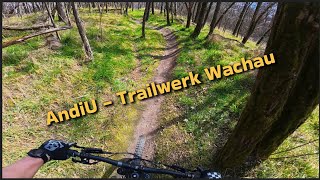
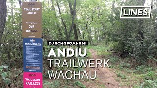
Der Trail schlängelt sich unterhalb der Georgskirche entlang eines flachen Bergrückens nach Furth. Kleine Geländekanten zum Springen oder Drüberrollen, Kurven, die je nach Geschwindigkeit auch Drifts zulassen - Ein Naturtrail, der für alle, vom Anfänger bis zum Experten, mit dem XC-Bike, wie auch mit dem Enduro spaßig zu fahren ist. Durch seine Ausrichtung im oberen Teil Richtung Süden ist er auch nach Regenfällen meist innerhalb kurzer Zeit trocken.
In Memoriam unserem Freund und Mentor Andreas Unfried, der bei einem Lawinenunglück ums Leben gekommen ist - Andi wir vermissen dich

source: AndiU
Local Trail Association
More Stats for AndiU mountain bike trail trail
  • Altitude change
    -239 ft
  • Altitude min
    1,149 ft
  • Altitude max
    1,412 ft
  • Altitude start
    1,412 ft
  • Altitude end
    1,175 ft
  • Grade
    -10.3%
  • Grade max
    -46.7%
  • Grade min
    19.2%
  • Distance climb
    272 ft
  • Distance down
    1,841 ft
  • Distance flat
    200 ft
  • Avg time
    00:02:45
  • Avg reverse time
    00:02:47
  • view trail stats
Status:
on Nov 10, 2022
Ideal
Avg: 4.45 (7 votes)
Your vote: 0

view (250)
close
3D
Trail Conditions
  • Unknown
  • Snow Groomed
  • Snow Packed
  • Snow Covered
  • Snow Cover Inadequate
  • Freeze/thaw Cycle
  • Icy
  • Prevalent Mud
  • Wet
  • Variable
  • Ideal
  • Dry
  • Very Dry
Trail Flow (Ridden Direction)
Trailforks scans users ridelogs to determine the most popular direction each trail is ridden. A good flowing trail network will have most trails flowing in a single direction according to their intension.
The colour categories are based on what percentage of riders are riding a trail in its intended direction.
  • > 96%
  • > 90%
  • > 80%
  • > 70%
  • > 50%
  • < 50%
  • bi-directional trail
  • no data
Trail Last Ridden
Trailforks scans ridelogs to determine the last time a trail was ridden.
  • < 2 days
  • < 1 week
  • < 2 weeks
  • < 1 month
  • < 6 months
  • > 6 months
Trail Ridden Direction
The intended direction a trail should be ridden.
  • Downhill Only
  • Downhill Primary
  • Both Directions
  • Uphill Primary
  • Uphill Only
  • One Direction
Contribute Details
Colors indicate trail is missing specified detail.
  • Description
  • Photos
  • Description & Photos
  • Videos
Trail Popularity ?
Trailforks scans ridelogs to determine which trails are ridden the most in the last 9 months. Trails are compared with nearby trails in the same city region with a possible 25 colour shades. Think of this as a heatmap, more rides = more kinetic energy = warmer colors.
  • most popular
  • popular
  • less popular
  • not popular
ATV/ORV/OHV Filter
Max Vehicle Width
inches

Radar Time
x Activity Recordings
Trailforks users anonymized public ridelogs from the past 6 months.
  • mountain biking recent
  • mountain biking (>6 month)
  • hiking (1 year)
  • moto (1 year)
Activity Recordings
Trailforks users anonymized public skilogs from the past 12 months.
  • Downhill Ski
  • Backcountry Ski
  • Nordic Ski
  • Snowmobile
Jump Magnitude Heatmap
Heatmap of where riders jump on trails. Zoom in to see individual jumps, click circles to view jump details.
Trails Deemphasized
Trails are shown in grey.
disable
Only show trails with NO bikes.
enable

Save the current map location and zoom level as your default home location whenever this page is loaded.

Save
      Directions to andiu trailhead (48.360630, 15.615410)
      update trails status or condition

      AndiU Trail Reports

      statusdatedescription
      Nov 10, 2022 @ 8:25pm
      Nov 10, 2022
      Oct 8, 2022 @ 1:20am
      Oct 8, 2022
      May 1, 2022 @ 11:56pm
      May 1, 2022
      reporter
      Jan 18, 2022 @ 11:55pm
      Jan 18, 2022
      reporter Forstwirtschaftliches Sperrgebiet: Andi U bis auf Weiteres gesperrt.
      Aug 16, 2021 @ 11:12am
      Aug 16, 2021
      reporter
      view all reports »

      Recent Ridelog Activity on Trail

      Past Week
      • 2 rides
      • 5 miles avg distance
      6 Months
      • 34 rides
      • 12 miles avg distance
      All
      • 139 rides
      • Last: Mar 31, 2023

      Photos

      more »
      7 |
      Feb 28, 2023 @ 7:38am
      Feb 28, 2023
      396 |
      Oct 19, 2019 @ 5:50am
      Oct 19, 2019

      Reviews / Comments

      No reviews yet, be the first to write a review or ask a question.
      Use trail reports to comment on trail conditions.


      We hope you've been enjoying Trailforks!

      Create a FREE account to view trail comments and much more.

      Videos

      more »
      AndiU - Trailwerk Wachau | LINES
      2:39 | 564 | Sep 21, 2019 , Furth bei Göttweig
      • subscribe
      • flag
      • login to download gpx or kml files.