Supporters, Builders, Maintainers & Land Managers of Andrassa Trail
Finale Outdoor RegionLand Manager
Andrassa Details
-
Activities
- Mountain Bike
- E-Bike
- Hike
- Trail Running
-
Riding AreaFinale Outdoor Region
Finale Ligure -
Ref Number#14
-
Difficulty Rating
-
Voted DifficultyBlue (2 votes)
-
Hiking SAC ScaleT1 Hiking
-
Trail TypeSingletrack
-
Bike TypeAM, XC
-
DirectionDownhill OnlyPopular direction shown
-
Climb DifficultyGreen
-
Physical RatingModerate
-
Trail VisibilitySometimes hard to follow
-
SeasonAll-year round
-
Dogs AllowedYes
-
eBike AllowedYes up to Class 1
-
TTFs on TrailRock Garden
-
Global Ranking
-
Local Popularity65 in Mountain Biking [+]
- 70 in E-Biking
- 65 in Trail Running
- 45 in Hiking
-
Year Opened2016
-
Land OwnerFinale Outdoor Region
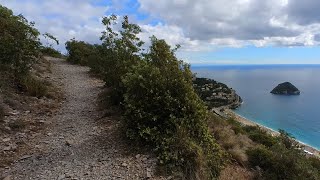
Stage number 6 EWS in 2016, this track follows 3 main, very different trails. Starting from a stunning panoramic view, it follows a mellow gravely line until a crossroad. After a steep couple of meters, it becomes a pedally section rolling down some small walls until the last sections where it gets technical, very close to a creek with some slow techy bits.
It rolls very close to the Andrassa cave: a natural 60m well, hidden in a jungly-type forest.
Access Info
Le Manie Area is reachable from the E80 highway accessing Spotorno. You'll need to take the SP8, then the SP45 towards Voze and you'll soon get to the top of the plateau.
Other option is getting out of the E80 in Finale Ligure, cross the town on the Aurelia (SS1) and driving up toward Le Manie on the SP45.
Disclaimer
Given its nature, the trail can change after weather happenings and season changes. Always pay attention.
Local Trail Association
-
Please consider joining or donating to the local trail association to supportdonate to earn trail karma!
trail development & maintenance.
More Stats for Andrassa mountain bike trail trail
-
Altitude change-405 ft
-
Altitude min911 ft
-
Altitude max1,317 ft
-
Altitude start1,317 ft
-
Altitude end912 ft
-
Grade-8.8%
-
Grade max-30.5%
-
Grade min2%
-
Distance climb49 ft
-
Distance down4,347 ft
-
Distance flat200 ft
-
Avg time00:08:04
-
Avg reverse time00:21:57
- view trail stats
- Unknown
- Snow Groomed
- Snow Packed
- Snow Covered
- Snow Cover Partial
- Freeze/thaw Cycle
- Icy
- Prevalent Mud
- Wet
- Variable
- Ideal
- Dry
- Very Dry
The colour categories are based on what percentage of riders are riding a trail in its intended direction.
- > 96%
- > 90%
- > 80%
- > 70%
- > 50%
- < 50%
- bi-directional trail
- no data
- < 2 days
- < 1 week
- < 2 weeks
- < 1 month
- < 6 months
- > 6 months
- Downhill Only
- Downhill Primary
- Both Directions
- Uphill Primary
- Uphill Only
- One Direction
- Description
- Photos
- Description & Photos
- Videos
- most popular
- popular
- less popular
- not popular
- mountain biking recent
- mountain biking (>6 month)
- hiking (1 year)
- moto (1 year)
- Downhill Ski
- Backcountry Ski
- Nordic Ski
- Snowmobile
Save the current map location and zoom level as your default home location whenever this page is loaded.
SaveAndrassa Trail Reports
Recent Ridelog Activity on Trail
- 11 rides
- 24 miles avg distance
- 144 rides
- 24 miles avg distance
- 1,361 rides
- Last: May 19, 2024
Photos
Routes with this trail
5 Reviews & Comments
We hope you've been enjoying Trailforks!
Create a FREE account to view trail comments and much more.
Nearby Trails
- Polveriera 669 ft
- Andrassa Easy 1,880 ft
- Scorciatoia Per L'andrassa 3,478 ft
- Cave 4,101 ft
- Up And Down To Andrassa 4,137 ft
Finale Outdoor Region
- By kaiser81 & contributors
- #69328 - 7,014 views
- follow/subscribe
- login to download gpx or kml files.
You must enter a description before submitting.