more stats
5,226 ft
Distance
19 ft
Climb
-248 ft
Descent
00:06:41
Avg time
-230 ft
Altitude change
331 ft
Altitude min
568 ft
Altitude max
561 ft
Altitude start
331 ft
Altitude end
-4.4%
Grade
-29.7%
Grade max
11.5%
Grade min
581 ft
Distance climb
3,517 ft
Distance down
1,125 ft
Distance flat
00:06:41
Avg time

Aneurysm Details

  • Activities
    • Mountain Bike
    • E-Bike
  • Riding Area
    Lysterfield Park
    Lysterfield
  • Difficulty Rating
  • Voted Difficulty
    Blue (16 votes)
  • Local Popularity
    85 in Mountain Biking [+]
    • 85 in E-Biking
  • Global Ranking
    #113 in Mountain Biking [+]
    • #1766 in E-Biking
  • Trail Type
    Singletrack
  • Bike Type
    DH, AM
  • Direction
    Downhill Only
  • Physical Rating
    Moderate
  • Dogs Allowed
    Yes
  • eBike Allowed
  • TTFs on Trail
    Berm, Drop, Jump
  • Land Owner
    Parks Vic

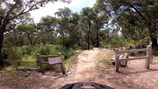
Fun track, quite flowy and fairly straight.
You don't have to take all the a-lines, but the a-lines are not that hard.
Fun track should be rated Blue Square.

Trail Supporters
  • Lysterfield District Trail Riders
    Builder
Local Trail Association
Traditionally Indigenous Territory

Recent Activity on Trail

Past Week
  • 8 rides
  • 12 miles average
6 Months
  • 200 rides
  • 14 miles avg distance
All
  • 2,288 rides
  • Last: Jun 28, 2026
c1c2c3c4
January
February
March
April
May
June
July
August
September
October
November
December
update trails status or condition

Aneurysm Trail Reports

statusdatedescription
Jun 21, 2026 @ 12:49pm (Australia/Melbourne)
Jun 20, 2026
Trail in great condition
Jun 17, 2026 @ 2:57pm (Australia/Melbourne)
Jun 16, 2026
Trail in great condition
Jun 14, 2026 @ 2:54pm (Australia/Melbourne)
Jun 13, 2026
Trail in great condition
Apr 4, 2026 @ 11:53am (Australia/Melbourne)
Apr 3, 2026
Good condition after recent trail works. New features not completely bed in yet but still running well.
Mar 8, 2026 @ 11:41am (Australia/Melbourne)
Mar 7, 2026
All trails in good condition, pretty dry n dusty in places, but running well Plenty of maintenance going on and all the new work on Aneurysm is...
more »
Status:
on Jun 21, 2026
Ideal
Avg: 4.07 (36 votes)
Your vote: 0

view (31,839)
close
3D
Trail Conditions
  • Unknown
  • Snow Groomed
  • Snow Packed
  • Snow Covered
  • Snow Cover Partial
  • Freeze/thaw Cycle
  • Icy
  • Prevalent Mud
  • Wet
  • Variable
  • Ideal
  • Dry
  • Very Dry
Trail Flow (Ridden Direction)
Trailforks scans users ridelogs to determine the most popular direction each trail is ridden. A good flowing trail network will have most trails flowing in a single direction according to their intension.
The colour categories are based on what percentage of riders are riding a trail in its intended direction.
  • > 96%
  • > 90%
  • > 80%
  • > 70%
  • > 50%
  • < 50%
  • bi-directional trail
  • no data
Trail Last Ridden
Trailforks scans ridelogs to determine the last time a trail was ridden.
  • < 2 days
  • < 1 week
  • < 2 weeks
  • < 1 month
  • < 6 months
  • > 6 months
Trail Ridden Direction
The intended direction a trail should be ridden.
  • Downhill Only
  • Downhill Primary
  • Both Directions
  • Uphill Primary
  • Uphill Only
  • One Direction
Contribute Details
Colors indicate trail is missing specified detail.
  • Description
  • Photos
  • Description & Photos
  • Videos
Trail Popularity ?
Trailforks scans ridelogs to determine which trails are ridden the most in the last 9 months. Trails are compared with nearby trails in the same city region with a possible 25 colour shades. Think of this as a heatmap, more rides = more kinetic energy = warmer colors.
  • most popular
  • popular
  • less popular
  • not popular
ATV/ORV/OHV Filter
Max Vehicle Width
inches
US Cell Coverage
Legend
cell carrier legend

Radar Time
Activity Recordings
Trailforks uses anonymized public activity data. ?
Activity Recordings
Trailforks uses anonymized public activity data. ?
Personal Heatmap
Activity Types
all / none
Options
2
Date range month
Winter Trails
Warning A routing network for winter maps does not exist. Selecting trails using the winter trails layer has been disabled.
Missing Trails
Most Popular
Least Popular
Trails are colored based on popularity. The more popular a trail is, the more red. Less popular trails trend towards green.
Jump Magnitude Heatmap
Heatmap of where riders jump on trails. Zoom in to see individual jumps, click circles to view jump details.
BC Backroad Status

Service Road Atlas is a free to use, community-driven service for viewing and creating reports on the numerous back-country service roads around B.C. and Alberta.

map legend
Slope Aspect
Direction the slope faces
Flat N NE E SE S SW W NW
Trails Deemphasized
Trails are shown in grey.
disable
Only show trails with no bike usage.
Enable
Suggested Layers
Based on selected activity type

    Save the current map location and zoom level as your default home location whenever this page is loaded.

    Save
        Directions to aneurysm trailhead (-37.939810, 145.273810)

        Photos

        23 more »
        154 |
        Jun 25, 2022 @ 7:15pm
        Jun 25, 2022
        154 |
        Jun 25, 2022 @ 7:15pm
        Jun 25, 2022
        307 |
        Jun 15, 2022 @ 4:45am
        Jun 15, 2022
        296 |
        Feb 7, 2021 @ 7:57pm
        Feb 7, 2021

        Videos

        15 more »
        Aneurysm December 2020 - Lysterfield Trail 15
        4:10 | 1444 | Dec 14, 2020 , Lysterfield
        Aneurysm Trail @ Lysterfield MTB
        4:07 | 925 | Dec 7, 2020 , Lysterfield
        youtuber Lysterfield MTB Park – Aneurysm
        4:00 | 1376 | Feb 17, 2019 , Lysterfield
        Lysterfield mountain biking - Melbourne's most...
        14:50 | 1030 | Sep 27, 2019 , Lysterfield

        Routes with this trail

        13 miles 1,215 ft 11
        really good route along lysterfeilds classic trails
        15 miles 1,627 ft 9
        if some trails are closed ride this.it may have one closure but it's fine ( i've rode it) probably an 2-3...
        5.0 7 miles 891 ft 2 Loop Race
        LDTR Golden Goat Junior Course 2023. This is the loop for the 2023 Golden Goat race hosted by Lysterfield...

        Links

        13 Reviews & Comments


        We hope you've been enjoying Trailforks!

        Create a FREE account to view trail comments and much more.

        • By NathanielTeh & contributors
        • #8406 - 15,737 views

        Frequently Asked Questions About Aneurysm

        Where is Aneurysm located?
        Aneurysm is located in Lysterfield Park, Lysterfield, Australia. It is part of the Lysterfield Park trail network. The trailhead is located at coordinates -37.93981, 145.27381.
        How hard is Aneurysm?
        Aneurysm is rated as Black Diamond difficulty. The physical rating is Moderate. The average grade is 4.4%.
        What is the elevation gain for Aneurysm?
        Aneurysm has 19 ft of elevation gain. The trail has 248 ft of elevation descent. The elevation ranges from 331 ft to 568 ft.
        Is Aneurysm a point to point trail?
        Yes, Aneurysm is a point to point trail. The direction is Downhill Only. The trail type is singletrack.

        Hit the Trail

        Open in App

        Get this trail on your phone instantly.
        open trail in app

        Download Trail

        Save to wishlist, Garmin & download.
        save the trail

        Find Related Routes

        Find routes and users activities that include this trail.
        find routes for this trail

        You must enter a description before submitting.